Preliminary Exploration of Copper Minerals in Jebal Barez Mountains, Iran ()
1. Introduction
Field observations in Jebal Barez Mountains indicate existence of a few copper deposits in feature of porphyry or vein systems. The aims of this paper are:
1) Definition of alteration zones related to copper mineralization.
2) Definition of porphyry and vein copper deposits depend on the shape and patterns of alteration zones.
3) Mapping faults of study area by using geological maps and satellites images.
4) Comparing alteration patterns with fault traces on regional geological maps.
5) Making a contouring map of Photolineament Factor based on Hardcastle method [1] to use as a data layer for tracing a map of probable copper deposits.
2. Geological Setting
Urumieh-Dokhtar magmatic belt with NW-SE trending is classified as an Andean type magmatic arc [2,3]. The northwestern part of the belt is the product of Neotethys oceanic plate subduction under the microcontinent of Iran followed by continent-to-continent collision of the Arabian and Eurasian plates. Collision has occurred in late Eocene [4]. Quaternary volcanic rock of the Bazman in southeastern part of the magmatic belt is the product of active subduction that continues along the Makran subduction zone [5]. The northwest collision and southeast subduction zones of the magmatic belt are separated by a convergent transfer zone and Sabzevaran and Gowk strike-slip fault systems (Figure 1) which are part of the Jebal Barez Mountains [6]. The transform zone contains highly faulted Eocene and Oligocene rhyolites, dacites and andesites. Intrusive rocks consist of Oligocene diorites, granodiorites and granite that formed in few different magmatic phases.
In Jebal Barez Mountains, most of copper deposits are typically associated with veins in faulted andesites, granodiorites and diorites or are associated with dikes [7,8].
Despite of northwestern part of UDMA which intrusion of small to intermediate igneous masses caused semicircular alteration zones and forming porphyry deposits, in the Jebal Barez Mountains intruding a huge mass of granite and granodiorites caused more dispersion of ore minerals in a large volume of rocks. Mapped alterations in the region tend to be more linear patterns associated with fractures and faulting (Figure 2), indicate potential

Figure 1. (a) Regional map of eastern Iran; (b) Major faulting in eastern Iran [6].


Figure 2. (a) Azurite and malachite forming in fractures; (b) Mineralization in fractures.
for polymetalic or epithermal vein mineralization than porphyry deposits [9].
3. Definition of Alteration Zones by Using ASTER Data
An Advanced Spaceborne Thermal Emission and Reflection Radiometer (ASTER), was used in study area to characterize alteration areas related to copper deposits. ASTER images provided preliminary mineralogical information and geo-referenced alteration maps at low cost and with high accuracy [10].
The ASTER consists of three subsystems with a total of 14 bands:
1) The VNIR subsystem by 3 bands obtains optical images (0.52 to 0.86 micrometers), with a spatial resolution of 15 m.
2) The SWIR subsystem also scans optical images of six bands (1.6 to 2.43 micrometers), with a spatial resolution of 30 m.
3) The TIR subsystem obtains images of five bands (8.125 to 11.65 micrometers), with a spatial resolution of 90 m [11].
From the nine bands data of VNIR and SWIR set many approaches for the discrimination and mapping of the surface mineral suites have been undertaken. Band ratio transformation was also useful for qualitative detection of alteration minerals [10]. Porphyry copper deposits are typically characterized by zoned assemblages of hydrothermal alteration minerals. These minerals exhibit spectral absorption features in the visible near-infrared (VNIR) and short wave infrared (SWIR) and/or the thermal-infrared (TIR) wavelength regions [12,13].
Logical Operators to Map Argillic and Phyllic Alterations
Based on laboratory spectra of muscovite, kaolinite and alunite resampled to ASTER band passes (Figure 3), muscovite (in phyllic alteration zone) spectrum display a 2.20 micrometers absorption feature, whereas kaolinite, and alunite (in argillic alteration zone) exhibit 2.17 and

Figure 3. Laboratory spectra of muscovite, kaolinite and alunite resampled to ASTER band pass. The spectra illustrate the position and intensities of absorption features [14].
2.20 micrometers absorption features [14]. FOR qualitative detection of alteration minerals and masking vegetation and dark pixels, logical operators which performed by Mars and Rowan (2006) was used to map alteration zone in study area.
(*1) Logical operator to map argillic alteration [15]:
((float(b3)/b2) and (b4 gt 260) and ((float(b4)/b5) gt 1.25) and ((float(b5)/b6) le 1.05) and ((float(b7)/b6) ge 1.03)
(*2) Logical operator to map phyllic alteration [15]:
((float(b3)/b2) le 1.35) and (b4 gt 260) and ((float(b4)/ b6) gt 1.25) and ((float(b5/b6) gt 1.05) and ((float (b7)/b6) gt 1.03)
Explanation of ENVI operators:
Float: convert to floating point le: less than or equal to gt: greater than ge: greater than or equal to Images of argillic and phyllic alteration zones are shown on the geological map of study area (Figure 4).
4. Structural Lineament
Most of major faults have been mapped by filtering of satellites images in Azimuth directions of 000,045,315 degrees, a RGB image of them is made to increase the width and clarification of linear phenomena on the land. Since roads and some artificial linear objects may confuse with structural lineament, by comparing the RGB image with geological maps and maps of roads, faults of study area are revealed and mapped more accurate (Figure 5).
5. Photolineament Factor
Since capability of fluid conduct, along a fault trace is different and it enhanced when two faults crosscutting each others, Hardcastle (1992) method [1] is used to make a contouring map of Photolineament Factor as a data layer. According to this method, a network contains of 10 × 10 kilometers quadrangle cells has been designed so that each cell has about 30% overlap with adjacent cells (Figure 5). Then by using the below Formula, Photolineament Factor is calculated for each cell.
(*3) 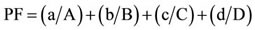
In the formula:
“a” is the number of lineaments in each cell and “A” is average of the number of lineament in whole network.
“b” is the length of lineaments in each cell and “B” is average of the length of lineament in whole network.
“c” is the intersection number of lineaments in each cell and “C” is average number of intersection of lineament in whole network.
“d” is number of directional sets of lineaments in each cell and “D” is average number of directional set in
 (a)
(a) (b)
(b)
Figure 4. (a) Phyllic and Argillic alteration zones transferred to geological map; (b) Appendix of geological map.

Figure 5. Faults revealed and image of quadrangle cells which designed for statistical studies, transferred to a RGB image of study area.
whole network.
By using calculated PF for each cell a contouring map of PF is made (Figure 6).
6. Aeromagnetic Data of Study Area
Recorded Aeromagnetic data with 7.5 kilometers distances of flight lines changed to map of magnetic field Intensity by using reduce to pole method (Figure 7). Previous surveying in UDMA indicated that zones with less Intensity of magnetic field can indicate hydrothermal alteration zones(specially propylitic zones) that probable having copper deposits. It is due to change of magnetic elements of rocks to Fe oxide, because of alteration process [16].
7. Preliminary Mapping of Copper Potential Deposits by GIS
Based on digital images and spatial data, some data layers consist of lithology, alterations, faults, aeromagnetic, photolineament factor and locations of known copper deposits, combined together in GIS and a preliminary map of copper potential deposits is made (Figure 8).
8. Discussion and Conclusions
Since the study area is very wide, by using remote sensing methods, the locations or area of alteration zones related to copper mineralization have been mapped. Field observation especially in NW of study area indicated copper deposits are typically associated with veins in faulted rocks or are associated with dikes. Many of faults and joints may reinforce the flow of hydrothermal fluids, despite it is hard to make a perfect correlation between high fractures/faults density and copper mineralization at a regional scale (1:100,000) geological maps, the results are acceptable.
On a regional scale, the low displacement is represented by negligible offset of stratigraphic markers with the fault, appearing as simple fracture. At hand specimen and microscopic scales, the faults may be manifest as a zone of highly fractured rock with no indication of offset [17]. So many of small faults cannot be defined and mapped by satellite images. Faulting and fracturing may enhance fluid flow, whereas high fluid pressure can also

Figure 6. Contouring map of photolineament factor.

Figure 7. Intensity of magnetic field by using aeromagnetic data (blue colored zones indicate less intensity).
generate crustal faulting and fracture network [18]. On the other hand, in the preexisting faults of a definite plutonic phase, may space creation during faulting be temporary with fault healing by hydrothermal vein precipitation. Faults that behave in this manner are analogous to valves that open and shut and control the flow of fluid during failure and healing [19].
Change of fault geometry, fault-fault intersection and presence of anisotropy such as bedding contact and igneous layering where the contacts are traversed by faults, produce variations in rock properties, which may lead to enhanced fracturing [17]. Hence the rate of fluids flow

Figure 8. Map of probable copper deposits by combination of data layers in GIS (Flags are locations of known copper deposits).
along a fault may be different and even enhanced along the splays of some faults. Torsion in the wall rocks of splay faults may produce high density fracturing locally [20]. Therefore many of the alteration processes may occur in the space between two parallel or adjacent faults which have noticeable splays. In conclusion because of difference of geometry, kinematic and timing of faults, we don’t hope the alteration areas which are defined by spatial images, perfectly coordinate with faults traces in regional scale geological map. We believe that high density of faults and quantity of Photolineament Factor are important factors for preliminary exploration of copper minerals.
9. Acknowledgements
This research is part of the Ph.D. thesis of Mohammad Yousef Mahmoodi at Department of Geology, Science and Research Branch, Islamic Azad University. Tehran, Iran. I like to thank Purhabib Mamaghani, R., for digitizing geological map and some software tasks and I am grateful to OJG editorial board and reviewers who helped to improve the previous version of this manuscript.
NOTES