Do Peripheral Development Increase Vulnerability? Case Study from Dhaka, Bangladesh ()
1. Introduction
About 54% of the world’s population with the majority of its capital assets are found residing in urban areas (UN, 2014). People are drawn to cities as they are recognized to be centers of economic activity, opportunity and innovation. Over the years’ urban areas, particularly the cities have become the center of attraction for the influx of large number of migrants from the country sides. Asia, the home of 4.4 billion people shares the largest (60%) number of the world population. Although, Asia is least urbanized (48%) compared to northern America (82%), Latin America & the Caribbean (80%) and Europe (73%). However, the pace of urbanization in Asia will be faster and by 2050 the Population will be 64% while 66% of the world’s population will be urban as projected1. The urban influence is felt far beyond administrative boundaries as large number of inner as well as population living outside the urban areas are interconnected and networked to maintain urban settlements. The trend of Urbanization will continue; therefore, wellbeing of the urban population will depend on the realistic management in a complex network of interconnected institutions, systems, infrastructure and information.
Human wellbeing in cities relies on a complex web of interconnected institutions, infrastructure and information (RF & ARUP, 2014). Cities serve as hubs of commerce, opportunity, and innovation, attracting people from all over the world. However, if cities do not have resilient planning, tensions might rise or unanticipated shocks can occur that could lead to social instability, physical collapse, or economic hardship. Therefore, increasing spatial, social and economic vulnerability in cities, a quick decrease in natural resources, an increasing number of natural ecological events and other crises in cities always indicate the need to pay more attention to urban resilience (Folke et al., 2004). The increasing vulnerability of cities to such sudden shocks and stresses are evident from the devastating impacts of natural disasters in recent years and the high socioeconomic losses associated with them. In the 2015 itself, Asia experienced 64% of the world’s fertilities due to natural disaster with economic damage totaled more than US$ 45.1 billion (UN ESCAP, 2015). Many of the major urban centers experienced natural disaster in 2015 including Nepal Earthquake with Kathmandu damage amounted one third of the national GDP, Chennai Flood resulting economic loss of US$ 7 Billion, heavy flooding in Jakarta, Indonesia; City of Joso, Japan and Dhaka, Bangladesh (UN ESCAP, 2015). This is common for the cities ranging from small urban centers upto Megacities. The scale of urban risk will continue to increase due to the ever-increasing urban population, accumulation of assets and investment pouring in to cities.
Spatial development/expansions of the cities towards the edge or periphery of the city are tend to be more exposed to natural hazards and for possible damage to property and life (Rumbach, 2014). Many of the cities in the developing countries particularly in Asia are growing Haphazardly and been exposed to natural hazards with possible threat to habitation (Walters et al., 2014). It is therefore, important to understand underlaying causes that making our cities vulnerable to natural hazards. This paper investigates the spatial development/expansion of the city and the potential risk to natural hazards through a detailed case study on the city of Dhaka, Bangladesh. In particular the eastern periphery of Dhaka city has been brought for detailed case study to understand how new development is leading towards vulnerable situation into hazard prone areas. This paper concludes on discussing the implication of the findings which might be useful for the planners and decision makers in dealing with new area development in Bangladesh or elsewhere in the similar context.
2. Urbanization and Disaster Risk
Towns and Cities in developing countries are growing fast and in many regions faster than expected. The pace of urbanization and population growth is such that both the proportion and absolute numbers of the world’s population residing in urban areas will increase, with the equivalent of the total current global population living in cities by 2050. The locations of cities remain a key variable in their overall exposure and vulnerability to disasters. Many cities are located and growing in places that are by their nature exposed to natural hazards and crises, such as the deltas, coasts and river basins. Additionally, many urban centres are located along earthquake fault lines. A tectonic plate in the Pacific Basin known as the Ring of Fire is the source of 81% of the world’s most powerful earthquakes and 90% of all earthquakes worldwide. Due of its close proximity to the Pacific Ring of Fire, Tokyo, Manila, Jakarta are particularly vulnerable to both earthquakes and volcanic eruptions. Tokyo is located directly on the Pacific Ring of Fire and has 452 volcanoes, putting its 37 million residents in constant danger from earthquakes and other natural catastrophes. Japan has a lot of tectonic activity, making it the region with the most damaging natural disasters. In Manila, typhoons, volcanoes, and tsunamis are commonplace, and earthquakes measuring more than 6.0 on the Richter scale happen often. The Philippines’ capital is second only to Tokyo in terms of overall riskiest city status (World Atlas, 2022). Clearly, place remains an important aspect of their overall hazard and risk profile (Friend et al., 2015).
Understanding the hydrological effects of urban growth is essential for urban planning i.e., it is necessary to assess land-use change in order to assist urban planning and related decision-making. The planning process requires reliable flood forecasting and accurate prediction of the surface runoff changes, which take place due to urbanization (Suriya & Mudgal, 2012).
Cities can be seen as crucibles of hazards that, without good management, generate extreme situations of vulnerability and risk for very large populations. Risk-accumulation processes in urban centres, such as ever-increasing numbers of people at risk from floods or accidental fires, are not so much inherent to urban development as produced by complex and dynamic interactions between human and naturally induced hazards and extreme conditions of vulnerability. The vulnerability of urban populations to disasters is not “natural”, but is constructed and amplified by economic, social and political systems. Changes in these systems can greatly reduce these vulnerabilities (Kamanga et al., 2003). Recent large scale natural disasters have brought natural disaster mitigation back to the forefront of policy debates in many countries throughout the world. Many policy analysts appear to have been swayed by the monotonic negative relationship between development and the risk of death from natural disasters that the current academic literature on the topic reports (Kellenberg et al., 2008).
The growing trend in climate-linked disasters poses worrying questions about the ability to respond to these related environmental emergencies. The staggering impact of natural and industrial disasters, particularly in developing countries, illustrates another significant trend—the growth of megacities and their vulnerability to disasters and environmental emergencies. The concentration of huge numbers of people in urban centers magnifies vulnerability to disasters and accidents, especially in informal settlements with insufficient infrastructure and poor to nonexistent land use planning (OCHA and UNEP, 2012).
3. Case Study: Dhaka, Bangladesh
This study is concerned with the spatial development in the city of Dhaka on different direction. To achieve the targeted goals and objectives the case study method is adopted studying eastern part of the newly developed locations in the city.
In comparing case studies with other research strategies (Yin, 1994), mentioned that “the case study is but one of several ways of doing social science research. Other ways include experiments, surveys, histories, and the analysis of archival information. Each strategy has peculiar advantages and disadvantages, depending upon 1) the type of research question, 2) the control an investigator has over actual behavioral events, and 3) the focus on contemporary as opposed to historical phenomenon.” In his answer to the question when and why a researcher should select the case study strategy, Yin, 1994, continues, “in general, case studies are the preferred strategy when ‘how’ or ‘why’ questions are being posed, when the investigator has little control over events, and when the focus is on contemporary phenomenon within some real-life context.” Another quality of the case study method is that it provides opportunity for the investigation to apply a range of data collection techniques and use evidence from multiple sources Although the case study method has many qualities and advantages in conducting empirical study, it has also some limitations.
The purpose of the study is to make a better understanding on the vulnerability of natural hazards due to spatial development. Therefore, it is to investigate how the present development processes going on despite there are related legislations. It is sure that for a better understanding and contribution of knowledge regarding this phenomenon it requires in depth inquiry. So, Case study approach is appropriate to understand and describe the real situation in this regard.
4. Eastern Fringe of Dhaka
After the independence of the country, the influx of population to the city of Dhaka continued, so as the development towards different directions. Many low laying areas been filled for housing development both by the public and private sectors for meeting the growing housing demand, however without considering the potential risk of natural hazard. Being located on the flood plain, Dhaka experienced a number of severe floods in the past, and its vulnerability to flood is obvious as it happened in the past mainly caused by spillover from surrounding rivers flowing to and from the major rivers of the country, as well as internal water logging. In recent history, Greater Dhaka city experienced major floods in 1954, 1955, 1970, 1974, 1980, 1987, 1988, and 1998 due to the overflow of surrounding rivers. Among these, the 1988 and 1998 floods were catastrophic (Haq & Alam, 2010).
The area between Balu River and Progoti Shoroni is demarcated as eastern fringe. It is a low laying area with patches of higher lands. For this study we have focused on two newly residential areas Namely Bashundhara and Aftabnagar adjoining areas. This zone is subject to regular annual flooding and turns into vast water body during rainy seasons. Prominent residential areas like Gulshan, Banani, Baridhara is within 2 km from this zone. The eastern part goes under water during rainy season quite regularly. This part also serves as the retention area to hold the run off of rain water for a large portion of the city through a number of natural drains. According to FAP-8B (JICA, 1991), the external and internal floods affect the eastern part of the city annually. Overflow of surrounding river causes external floods while storm water flooding due to insufficient drainage facilities causes internal floods. A JICA team had conducted a survey under the FAP-8A project in 1991 covering 118 sq km in eastern part and a part of Greater Dhaka of west (47.74 sq∙km) with built-up areas and drains off eastwards to the Balu River. It reveals that 47% area is usually affected by annual flooding. Most of the lands are submerged during this season. Rural villages and settlements are likely isolated but still flood-free because their houses are built a little higher than the annual flood stage.
After the devastating flood in 1988 government took initiative to construct embankment around the city to protect from seasonal flood. A 30 km long road cum embankment was proposed along the western bank of Balu River in order to protect the entire area from flood. After this proposed plan, about 25 housing projects have been initiated in the eastern fringe over last two decades. A number of these housing estates are already partially implemented. It is expected that other housing estates will be implemented within next few years. It was already discussed that eastern fringe is a low laying area where flood is a common phenomenon. Major parts of the area remains under water during rainy season. These water bodies are being filled in by land developers for housing estate development.
Bashundhara housing estate is the largest housing project in eastern fringe. After initiation of the project in 1985 a lot of changes have taken place in and around the site. Analyzing IRS image of the site it is clear that there were about 275 acre developed land in 1996. This development took place between 1985 and 1996 at a rate of 25 acres per year. In 2016 total developed area was about 716 acres which took place between 1996 and 2016 at an annual increase of 36 acres. Analyzing image of 2016 of the area it is evident that about 653 acres of land is under the process of development. Land development intensity has increase during last decade (1996-2016) by three times than that of previous decade (1985-1996). It is estimated that during the development process wetland/water body has been disappeared by 575 sq meters per year in and around Bashundhara residential area.
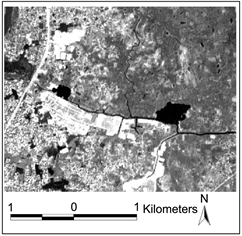

Aftabnagar Area (on the Left) the Arial view of the residential area in 1996 where black large areas are the evidences of large water bodies. (right in 2017) Water bodies that of in 1996 are disappeared and development has taken place with residential and other urban usages [verified during field survey].
In the southern part of the Eastern Fringe a number of branches of natural drains have disappeared due to development of housing estates. After analyzing IRS image, it is evident that a branch of natural drain originated from Balu ran through badda and Noadda was connected with Begunbari khal about 1 km on the west of Rampura Bridge in 1996. This natural drain used to carry rain water of south Badda into Bagunbari Khal. About 1260 feet of the natural drain (with an average width of about 60 feet) near Begunbari Khal disappeared since 2000 when Aftabnagar Housing project was initiated. Moreover, a good portion of water bodies were disappeared at the same time.
5. Possible Disaster Risk
What are the possible disaster risk of households living or going to live in the future in the eastern fringe? Is there any effect to the adjoining areas due to disappearance of natural water bodies from the area? How do low-income households living in the nearby areas and been exposed to environmental hazards like monsoon rains? To understand all these questions, the author designed questionnaire and conducted interview in the study area. A total of 135 households were surveyed and senior residents from the areas were interviewed to know the previous situation in the area in terms of the effects of floods in 1988 and 1989 and the period when agriculture was the main activities of the area.
Water Logging and Flood Vulnerability
Disappearance of natural water bodies due to development is a common phenomenon in all fringe areas of Dhaka city (Rahman, 2007). A large amount of water bodies was disappeared during development of Bashuandhara and Aftabnagar Housing Estate. These problems are also common for all zones. Similar study by Islam (2006) indicates that a total of 19,134 square feet of wetland is lost every day in Beraid, 7161 square feet in Baghair and 2446 in Ashulia in Dhaka due to development of housing estates. During the interview with the local inhabitants in the study area. About 34% of the houses experience water inundation in the ground floor after short period of rainfall during the rainy season. While about 80% of the respondent informed about the inundation of the roads that disrupts the normal communications. The inundation durations are also gradually increasing in the area. The intensity of water logging at adjacent Kalachadpur area in eastern suburbs has increased due to loss of water bodies during development of Bashundhara Housing Estate. The loss of natural drains during development of Aftabnagar Housing Estate has created water logging problems in Badda area. While talking to the local residence, it is understood that the duration of waterlogging during (see Table 1) rainy seasons has been prolonged than that of a decade ago as evident from the similar research by Rahman in 2007.
The eastern area is under fast development due to a number of housing estate development. It is expected that the average height of the entire area would be raised by the year 2050 to cover overall by 71 percent compared to the coverage in 2004 by 19 percent. Major land-use categories in 2004 consisted of agriculture (34.4 percent) and residential use (34.2 percent), followed by vacant land (14.0 percent) and water bodies (13.2 percent) (The World Bank, 2015). By 2050, the residential category is expected to account for 58.28 percent of land use, and residential/commercial mixed-use area will comprise 8.11 percent. The water
![]()
Table 1. Water logging at Kalachadpur area in different years.
Source: Water logging depth and duration from Rahman (2007) and Field interview during June 2017 and Rainfall record from Official Record by the Metrological Department, Dhaka, Bangladesh.
retention area will cover 11.99 percent, while the proposed road network will comprise 8.53 percent as the study by the world bank described. This is to be noted here that after the devastating flood in 1988 for protecting the eastern part of Dhaka, a road cum embankment was proposed along the Balu River. While the government or any donor agency has not yet made any detailed landuse plan for the eastern fringe or the plan to execute the construction of the embankment, the booming housing sector has filled large section of the area for developing housing estates (Halcrow Group Limited, 2006). While conducting observation survey through the newly developed Bashundhara Area, it is observed that the plinth level of most of the buildings are at the same level that of the road level. These buildings are constructed within last 8 to 10 years well after the last catastrophic flood event in 1998 and 1988. While talking wo the senior residents from the area, a number of respondent could recall the flood height in the area which was almost the half of the ground floor height. Study by (Haq & Alam, 2010) also has indicated the flood height in the area to the level of about 2 meters.
Construction of Buildings on Infill Land and Earthquake Liquification Effects:
Major portion of Bashundhara Residential area are on infill land. The Project was approved in 1987 for an area of 123.53 hectares at the first phase. The approval was in accordance with the 1959 Master Plan. During the period of the approval, there was no specific guidelines for preservation of natural water bodies. Devastating flood of 1988 realized the need for waterbody protection and accordingly city Master plan was revised for a period of 20 years (1995-2015) known as “Dhaka Metropolitan Development Plan (DMDP)”. A large portion of eastern fringe was demarcated as water retention pond not to be used for any development purpose (RAJUK, 1995). However, the filling of low laying areas continued for housing area development. Many of the areas were filled with the loose sand and soil upto 30 to 40 feet depth. A loose soil tends to compact when sheared and, without drainage, pore water pressure increase. Liquefaction is most commonly observed in shallow, loose, saturated deposits of cohesionless soils subjected to strong ground motions in large-magnitude earthquakes. During the Kobe Earthquake in 1995, extensive liquefaction occurred in the fill deposits of Masado soils at Mikagehama Island. Scattered sand boils, lateral movement, settlement and tilting of the ground were typical features of ground deformation (Cubrinovski et al., 2001). A Study by the Ministry of Disaster Management and relief of the Government of Bangladesh on Liquefaction Susceptibility of Dhaka indicates Easter Part of the city within the range of high to very high Liquefaction Susceptibility. The identified areas by the study are the same places where large number of building was constructed during last 25 years. Although there is no recent history of large earthquakes in Dhaka city or within Bangladesh. However, the active faults within the country may generate medium to large earthquake (CDMP, 2009). In the Bashundhara Residential area, about 90% of the buildings are concrete structure (BBS, 2011) and highly vulnerable to earthquake liquefaction effect.
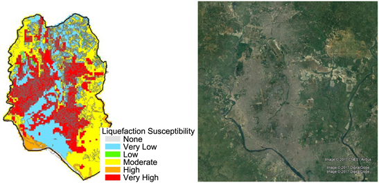
(Left) Earthquake Liquefaction Susceptibility Mapof Dhaka City and Surrounding Areas (prepared by CDMP, 2009) shows Liquefaction susceptibility ranges in different areas. (right) Red circled area is the Aerial view of Eastern Part of the City where development is taking place on marshy lands (Source: Seismic Hazard Map of Dhaka, CDMP, 2009 and Google Earth Map).
Loss of Biological Resources: Flora, fauna and number of fish species were disappeared in eastern fringe over last one decade. Area of cultivable land also reduced to about 50% while production of rice reduced by 60% due to encroachment by housing estates in eastern fringe. During development of Aftabnagar housing estate in the same zone about 273 acres of agricultural land and green spaces were disappeared. It is also estimated that the process of housing estate development is also threat to the existence of remaining water bodies and flora & fauna. Similarly Bhatta (2010) describes urban sprawl due to development of housing estates has led to a greater amount of undeveloped land to be converted to urban development in different countries.
6. Reasons for Increasing Vulnerability
Dhaka Structure Plan (1995-2015 & 2016-2035) has given a broad framework for the development control and future expansion and has indicated further detailing through Detailed Area Plan (DAP) preparation. However, until recently RAJUK could not complete Detailed Area Plan for proper monitoring the development that took place on the eastern fringe. According to Schedule-1 (D) of Environmental Conservation Act 1997, sixty-nine categories of polluting industries that require submitting Environmental Impact Assessment Report. This list also includes Water treatment plant, Sewerage pipe line laying/relaying/extension. Water, power and gas distribution line laying/relaying/extension and Construction/reconstruction/expansion of road. The mentioned items are parts of a housing estate. The Environmental Conservation Rules does not categorize housing estate as a polluting industry/project. As Housing Estate is not in the list of projects requiring EIA, RAJUK and other public agencies do not conduct EIA during development of Housing Estates. Section 2 (f) of Natural Water body conservation Act 2000 defines river, khal, bil, dighi, stream or water reserves, flood flow zone or any place where water retains as natural water bodies. The term “Pond”-most popularly known everywhere in the country and demarcated in land ownership maps has not been mentioned under the definition. As a result, anyone willing to fill in pond can apply to RAJUK and he/she cannot be prevented as this rule does not indicate the term specifically. Due to the improper definition, good numbers of water bodies are being filled in Dhaka as well as in other parts of Bangladesh. From above discussion, it is evident that there are weaknesses in existing policies, rules and plans. The shortcomings in the different legislations giving opportunities to the land developers for illegal development which is ultimately bringing adverse impact on the environment and susceptible to liquification potential.
Earthquake Risk assessment results indicates Dhaka as one of the most vulnerable cities in Bangladesh. Risk assessment results indicates that a 6.8 Mw earthquake originated from Madhupur Fault (90 km from Dhaka) may cause substantial damage to 72,000 buildings in the city (CDMP, 2009). Specially newly developed lands in the eastern fringe are highly susceptible to soil liquefaction potential with possible significant damage to the infrastructure.
7. Discussion and Conclusion
It is evident from the overall analysis of the research that notable development in the urban fringe took place during last decades. This change is due to the fast-growing population of the city & housing demand, increasing land demand in the built-up areas and availability of land in city periphery. There are regulations and Master Plan to guide environment friendly housing estate development in Dhaka. Despite of that, weak institutional settings and faulty legislations are leading to illegal development which is ultimately leading the city vulnerable to natural hazards. Most of the recently initiated housing estates in the eastern part of the city are located on low lying areas and effecting the environment through grabbing natural water bodies, biological resources, increasing water logging, flood vulnerability and earthquake liquification effect. Therefore, without a proper guidance regarding the environmentally compatible development, it is not possible to ensure resilient development for the case of Dhaka. It requires a number of changes and restructurings in specific areas for environment friendly development in this regard.
This paper highlights the practical example of vulnerable factors to natural hazards, with a view to assist the city authority for taking appropriate measures in Bangladesh that are needed for reducing risk of city development. Initiatives for effective risk reduction measures must start with proper understanding of the development trend, and associate vulnerabilities. This is important for the developing countries like Bangladesh, experiencing rapid urbanization. Additional comparative studies are needed to understand the vulnerabilities of peripheral development in order to take appropriate measures.
NOTES
1The World Urbanization Prospects, UN (2014).