Numerical Groundwater Flow Modeling of the Coastal Plain Sand Aquifer, Akwa Ibom State, SE Nigeria ()
1. Introduction
Akwa Ibom State was founded 26 years ago. According to the census figures, the population was 2,409,613 inhabitants in 1991, while in 2006, 3,902,051 people lived in the area. This growing population alongside expansion of urban, agricultural and industrial activities has led to an increase in the demand for water in the area. The demand is partly achieved by the indiscriminate sinking of boreholes by individuals, communities, private organizations, government at local, state and federal levels and donor agencies including UNICEF, EU, ADB, the World Bank, etc. All these activities result in an increase in groundwater abstraction from the main hydrogeological unit, the Coastal Plain Sand aquifer.
What worsens the situation is the lack of a law enabling the control of the abstraction of groundwater in the area. Hence, there is a need for an effective management document to be in place for conserving and controlling the use of the available groundwater resource. This study therefore is the first attempt to numerically model groundwater flow under steady-state conditions in Akwa Ibom State. The main objective is to develop a regionalscale steady-state groundwater flow model for the area. Minor objectives include the determination of hydraulic conductivity and recharge characteristics using available hydrogeological information and applying inverse modeling technique based on the pilot point and zonation techniques.
2. Study Area
2.1. Geographic Setting
Akwa Ibom State shown in Figure 1 [1] , is the one of the coastal states in the Niger delta region of Nigeria covering an area of about 7081 km2, extending between latitudes 4321 - 5331 north and longitudes 7251 - 8251 east. It is about 150 km long and its width varies between 60 km in the north and 100 km in the south with an average elevation of about 60 masl. The area is bounded on the south by the Atlantic Ocean, on the southwest by Imo River and southeast by Cross River. On the northwest, north and north east the area is bounded by Cretaceous to Tertiary sediments. Precipitation is high in the south (>3000 mm/a) and decreases northwards (<2000 mm/a) with an average of 2500 mm/a [2] . Air temperature (26˚C - 28˚C) is uniform throughout the year [2] [3] . During dry season, the water level in rivers and streams decreases suggesting that part of the river is recharging the aquifer besides precipitation. Pan evaporation rates vary between 4.6 and 5.0 mm/d [2] . The Akwa Ibom area lies within the region of Nigeria, which is characterized by equatorial climate and tropical rainforest [4] .
2.2. Geologic Setting
The geology of the Akwa Ibom area has been extensively studied by [5] -[9] . As presented in these publications, the area is underlain by late Cretaceous to Quaternary sediments. The lowermost sediment is lateritic sandstone with minor shale of the Maastrichtian Nsukka Formation. Throughout the Paleocene to Early Eocene, a thick shale intercalated with sandstone and limestone was deposited (Imo Shale Formation), while in the middle of the Eocene semi-consolidated sandstone, siltstone and minor shale were deposited (Bende Ameki Formation). Since the Miocene-Oligocene grit and sand with intercalations of clay and lignite beds were deposited constituting the Ogwashi-Asaba Formation. Overlying this formation is a thick sequence of gravel, sand, silt, and clay constituting the Benin Formation also known as the Coastal Plain Sands and alluvial ridges.
2.3. Hydrogeologic Setting
The area has three hydrostratigraphic units including the Alluvial Deposit, Coastal Plain Sand and Lower Sand Aquifers [10] [11] . The Coastal Plain Sand aquifer is the most extensive and is separated from the Lower Sand aquifer by the Imo Shale aquiclude. The aquifer is composed of sand, gravel, and sandstone with clay intercalations. The thickness of the aquifer varies between 35 m in the north and 200 m in the south. The aquifer is considered to be semi-confined or unconfined, especially in the southern parts of the area. The main groundwater flow direction is from north to south into the Atlantic Ocean. There are also variations in the northeast-southwest and northwest-east directions into the Imo River and the Cross River.
3. Groundwater Flow Model
Based on the knowledge of hydrogeological system, a steady state mathematical model of the coastal plain sand aquifer was developed. The area of study is 7081 km2, therefore the model has a regional character. The hydrogeological conditions were defined from more than 200 boreholes drill log. Borehole data were obtained from [1] .
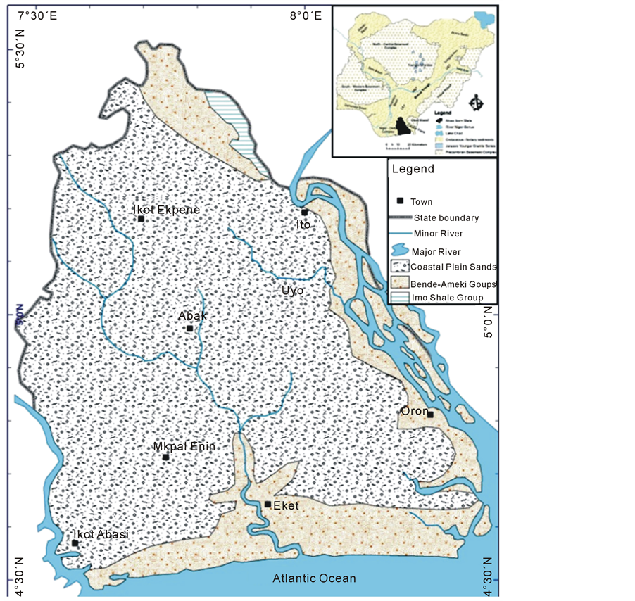
Figure 1. Map of the study area, Akwa Ibom State, Nigeria (Adapted from Emmanuel, 2013).