Examining the Impact of Physical Development Practices and Control in the Savelugu Township ()

1. Introduction
There has been an increasing trend in urbanization globally, resulting from the corresponding increase in the human population, which has become a major concern [1] [2] . In 2014, about 54 percent of the world’s population resided in urban areas. It’s projected that by 2050, 66 percent of the world’s population will be urban [3] . In addition, UN-Habitat (2009) [4] estimated that Africa’s urban population would increase from 294 million to 742 million people between 2000 and 2030 [2] .
In Ghana, projections indicate that by 2025, 63 percent of Ghana’s total population will live in urban areas [2] . According to Adarkwa and Post (2000) [5] , Ghana’s cities have seen tremendous changes in size, density, and areal extent. Indeed, with an annual growth of about 2.4 million people, Ghana’s population is continuously on the increase. This ultimately increases the urbanization trends in the country [6] . Over the years, this has serious impacts on lands in Ghana. It has also caused a high demand for lands for various uses [5] .
According to Wang et al. (2001) [7] , physical development usually yields positive outcomes where development controls are strictly enforced. While development controls have been utilized with a degree of success to ensure harmonious spatial distribution of activities in advanced countries, their application has been problematic in developing countries [7] [8] . Ogundele et al. (2009) [9] suggest that physical development does not necessarily conform to planned outcomes in most cities in third world countries. As a result, many third-world cities’ built environments are rapidly deteriorating despite planning legislation to monitor and control development [10] . Today, the state of the physical environment, particularly the urban centres, is a major source of global concern. Poor development control has also become a major challenge in many towns and cities across Ghana. Yeboah and Obeng-Odoom (2010) [11] note that urbanization has outpaced planning in Ghana, and physical development has been haphazard.
It is for this reason that this study is conducted in the Savelugu Township to unravel the challenge physical development faces and its impact on the physical layout of the township. Savelugu being a fast-growing town, as a focus will inform the trend for other equally fast growing towns within the northern region. Even though there are physical development regulations, physical developers seldom utilize the regulations for physical developments in the area. This study most importantly among other reasons, focused on the challenges developers face in acquiring development permits and examining the impact of physical development practices and control in the Savelugu Municipality in response to the increasing phenomenon of rapid urbanization in the Savelugu Township.
2. Literature Review
Development is a broad concept that entails social, economic, political, and human activities. Human development constitutes the foundation on which the first three concepts are based. According to Burkey (1993: 38) [12] , economic and political development must translate into social development. For this study, the concept of development will focus on the physical and spatial dimensions of development. The idea of spatial development is comprehensive and generally viewed as universal in all parts of the world. For example, Ghana’s Town and Country Planning Ordinance of 1945 (Cap 84) defines development as any building or rebuilding operations and any use of land or any building for the purpose for which the land or building was last being used. This definition is like the case of England where the Town and Country Planning Act 1971 Section 22 (1) defines development as “the carrying out of the building, engineering, mining and other operations in, on, over or under land; and the making of any material change in the use of any buildings or other land”. Regarding the above definitions, the concept of development in the planning field goes beyond just the presence of erected structures to include legal frameworks. In a simple form, development can be seen as a change process from one state of the built environment or land to an alternative state [13] .
Development control, therefore, fulfils a fundamental purpose in the growth of urban centres. According to Thomas (2013) [14] , development control is part of the broader purpose of town and country planning, and ultimately environmental planning. At the highest level of generalization, development control ensures efficient and effective land-use planning that satisfies public interest. Ogundele et al. (2011) [9] also propose that development control is necessary for ensuring that activities on the land and building development do not compromise good practices, hence, misuse or abuses are curtailed. Landowners and leaseholders wishing to develop on their land must apply for development permits, and a development proposal must comply with the requirements. When an application is made for a development permit (to subdivide land or build), the proposal is assessed by technical experts within the authorities against the scheme’s provisions. In addition, the application is evaluated to manage potential impacts on roads and traffic, public health, safety and amenity, natural environment and systems, and lifestyles (Town and County Planning). Development control tools are neither machinery nor equipment, but the elements used to implement development control. In controlling development in Ghana, many tools are employed and the most commonly used include; land-use zoning, planning standards, building and development permit application and approval, as well as monitoring and enforcement (which involve stopping work notices, and sanctions among others). In Ghana, a stop-work order could be issued where it appears to the control department that: 1) An unauthorized development is being carried out or; 2) Where development does not comply with a development permit issued by the control department. This document is used pending the service of an enforcement notice on the owner, occupier or holder of such property. It takes an immediate effect upon the service of such property (see Figure 1). The time frame is usually 21 days, within which such development shall comply. It shall cease to have effect if within 21 days enforcement notice is not served on its contravener [9] .
2.1. Profile of the Study Area
The Savelugu Municipality is one of the 260 Metropolitan, Municipal and District Assemblies (MMDAs) in Ghana and forms part of the 16 MMDAs in the Northern Region. The Municipality was carved out of the then Western Dagomba District Council, which comprised Tamale, Tolon and Savelugu. The Municipality has its administrative capital at Savelugu. It is located in the northern part of the Northern Region of Ghana and has a total land area of about 2022.6 sq∙km. with a population density of 68.9 persons per sq∙km. It shares boundaries with West Mamprusi Municipal to the north, Karaga District to the east, Kumbungu District to the west and Tamale Metropolitan Assembly to the south (see Figure 2). The altitude of the Municipality ranges between 400 and 800 feet above sea level. According to the 2010 population and housing census, the population of the Municipality stands at 139,283, with 67,531 males and 71,752 females (2010 population and housing census).
![]()
Figure 1. A stop work notice written on a store container by the Savelugu Municipal Assembly. Source: Field survey, 2021.
![]()
Figure 2. Map of Ghana indicating the Savelugu Municipality. Source: Author’s construct, 2021.
2.2. Research Methodology
It is acknowledged that several methodological options are available in social research. But the choice of a research methodology is dependent largely on the objectives of the study [15] . This leads the discussion on research design, source of data, study population, sample size, data collection instruments, sampling techniques, data collection procedure, and methods of data analysis.
2.2.1. Sampling
The study made use of both probability and non-probability sampling methods. With the probability sampling, we employed the use of the simple random sampling, with the sample frame including three selected neighborhoods in the study area. These neighborhoods were categorized into three based on physical development, availability of infrastructure and essential services. The study used simple random sampling to select three neighborhoods. That is one neighborhood each from a category. Category A comprised of Moshi Fong, New-town and Nakohagu. Category B comprised Liman Fong, Kuga Fong and Kpalyogu. Category C comprised Lungsi Fong, Kpatuli Fong and Nayili Fong. The non-probability sampling method used purposive sampling to select four officials from the planning department and the Department of Works since they were considered resourceful and had the relevant knowledge of the topic under study.
2.2.2. Sample Size Determination
In terms of the sample size determination, data from the Statistical Department of the Assembly revealed a total of 169 houses in the selected neighbourhoods. The study operated at a 95% confidence interval with a 5% margin of error. The Yamane (1967) method was used to determine the sample size.
where n = sample size, N = sample frame (169) and (e) represent the margin of error which is 5%, with a confidence level of 95%. By substituting this into the formula:
This figure was proportionately distributed among the three categories of neighborhoods identified, and the details are presented in Table 1.
After determining the sample size and the proportionate distribution of the sample size among the various categories, the study used simple random sampling to select the respondents (property owners) in the multiple categories until the required number was obtained.
To the institutions, purposive sampling was used to select four (4) respondents, two each from the two departments (Physical Planning Department and Works Department). These officials were purposively selected because they are resourceful and have relevant knowledge about the topic under study.
2.2.3. Data Collection Tools and Techniques
In terms of the tools and techniques for data collection, questionnaires were administered to property owners by the researchers. In all, about 118 questionnaires were administered by the researchers for property owners in the Savelugu
![]()
Table 1. Proportionate distribution of sample size among the selected neighborhoods.
Source: Authors’ construct, 2021.
Township. The questionnaire contained both close-ended and open-ended questions. The open-ended questions were used to control the participants’ responses. Close-ended questions allowed the group to control the participants’ responses and enabled us to obtain relevant and reliable information on the challenges property owners face in obtaining development permits. The questionnaire asked questions about the respondents’ demographic characteristics and on the study’s objectives. Questionnaire and Unstructured Interviews were used to collect data from officials of the Physical Planning Department (PPD) and the Works Department (W.D.). The data gathered hinged on the study’s third objective, which is on the challenges associated with physical development practices and control in the Municipality.
2.2.4. Sources of Data
Primary data for the study was obtained through the interview from officials of the Assembly, property owners, direct observation and photographs which supported the discussion. Questionnaires were used to collect preliminary data from the officials and property owners. The secondary data source included documented review, specifically, planning documents, books, journals, newspapers, thesis and dissertations, conference proceedings, reports, and the internet, among others on the subject matter which are duly cited at the reference section.
3. Results and Discussion
3.1. Age of Respondents
Data on the age of respondents were collected because the age of respondents was considered one of the key factors that influence development control practices, especially in the area of compliance. The result is presented in Table 2.
Data from the field, as presented in Table 2, indicates that the ages of most of the respondents ranged from 40 - 89 years. However, a considerable number of
Source: Authors’ construct, field survey, 2021.
them (21%) were between the ages of 70 - 79 years while only three percent of respondents (3%) were between the ages of 30 - 39. This clearly shows that most of the respondents were up to age in terms of understanding development control practices and regulations in the study area. Therefore, any information coming from them may be reliable.
3.2. Gender of Respondents
The study considered gender as one of the essential components, even though it is largely observed that males own most houses. As shown in Figure 3, data from the field indicated that males owned the majority of the houses (72%) in the study area, with females owning only 28 percent of houses in the study area. Therefore, the fact that most homeowners are men reflects a traditional African society, where men are regarded as heads of households and as well function as caretakers of properties (houses and farmlands).
3.3. Level of Education
It is believed that an individual’s level of education has an impact on how person understands issues and observes activities in society. Therefore, understanding how development control activities are carried out is a step towards ensuring effective development control. The study considered the educational level of respondents as very crucial to achieving the objectives of physical development control. Therefore, it sought to find out the educational level of respondents and details are presented in Figure 4.
![]()
Figure 3. Gender of respondents. Source: Field survey, 2021.
![]()
Figure 4. Educational level of respondents. Source: Field survey, 2021.
Data collected from the field, as shown in Figure 4, indicates that the majority of the respondents (59%) did not have formal education. Only 15%, 17%, and 9% had formal education up to the primary, JHS, and Tertiary levels, respectively. This is most likely going to affect development control practices and compliance level with regard to development control regulations.
3.4. Employment Status of Respondents
The respondents’ employment status plays a significant role in relation to their ability to afford fees associated with acquiring development and building permits and even the pace at which houses can easily be built when permits are secured. The study, therefore, sought to enquire about the employment status of respondents with regard to the topic under study. The details are presented in Figure 5.
It can be observed from Figure 5, that the majority (73%) of the people were unemployed formally. However, most of them indicated that they were engaged in farming and other activities. Twenty-seven (27) percent of respondents stated that they had formal employment. This will affect their patronage of development control mechanisms, including permit acquisition, among others, since their income levels are most likely low.
3.5. Assessing the Level of Awareness and Patronage of Development Control Practices
The level of awareness of every initiative, policy or practice directly impacts on the patronage of that particular initiative or policy. Therefore, development control is considered crucial in the development of every geographic area, especially in this modern era where it has become necessary to prevent environmental and social problems associated with uncontrolled physical development. The study considered determining developer knowledge of development control regulations as one of the most basic ways of measuring development control in a given location. Moreover, the level of public awareness has a direct impact on compliance. As a result, residents of the township were asked if they were aware of statutory laws governing development control in Ghana with specific emphasis on the study area. The details are presented in Figure 6.
![]()
Figure 5. Employment status of respondents. Source: Field survey, 2021.
![]()
Figure 6. Awareness level of developers on development control laws. Source: Field survey, 2021.
As presented in Figure 6, data from the field indicates that the majority (82%) of homeowners (developers) were not aware of regulations governing development control practices in Ghana with specific emphasis on the study area. On the other hand, a low number of respondents (18%) said that they were aware of statutory provisions regulating development control in the study area. This is, therefore, a clear indication that the awareness level of developers with regard to development control regulations is extremely low. This demonstrates that a problem exists regarding the level of awareness, and this is likely going to limit the ability of developers to acquire the necessary permits before embarking on physical development activities (construction activities) in the Savelugu Township. However, respondents who said they were not aware of these regulations attributed it to their low literacy level. Therefore, one can say that this will affect their level of compliance since they do not know these regulations exist to guide their activities, especially in areas where these laws are not effectively enforced.
3.6. Permit Acquisition by Developers
According to Somiah (2014) [16] , building permits grant approval to prospective developers to build structures in approved locations. Therefore, in building a house or putting an improvement on land, obtaining a permit (development and building) is very critical. This is because these developments must be regulated in accordance with Town Planning regulations to prevent haphazard development and its associated challenges. The study used a survey to collect data on this issue. Respondents were questioned whether they acquired permits before developing their houses. Data obtained from the field is presented in Figure 7.
In Figure 7, 21 respondents indicated that they were aware of statutory provisions guiding development control. Out of the total number of 21 respondents (100%), 7 respondents (33%) said they obtained building permits before developing their houses. In terms of the stage at which they obtained these permits, respondents revealed that permits were acquired before putting improvements (buildings) on their lands. However, 14 respondents (67%) did not obtain permits before developing the houses on their land. It was interesting to unravel that some of these respondents inherited their houses and were not provided with any documents relating to permits obtained before these developments
![]()
Figure 7. Permit acquisition by developers. Source: Field survey, 2021.
were put on the land. Respondents who obtained permits made it known that these permits were obtained from the Savelugu municipal assembly. However, they complained of the cost involved and the bureaucratic nature of obtaining these permits. Authorities must therefore take a critical look at these issues raised. Respondents who did not obtain permits also indicated that the bureaucratic nature of the processes involved made them develop without obtaining a permit. They also mentioned that the cost involved in obtaining a permit was also a challenge, and went ahead to add that they were unable to raise enough funds to build their houses. This, as found by the study, was attributed to the low level of public education and ignorance on the part of developers. This demonstrates that much work still needs to be done by the Assembly to create awareness and enforce development control regulations in the Savelugu Township. Therefore, regulations guiding physical development must be given the needed attention by the appropriate authorities.
3.7. Compliance to Alteration Regulations (Alterations to Buildings after Initial Construction Development)
According to L. I (1630), any developer who intends to make any improvements, whether in the form of an extension, conversion, or both, must submit an application to the District Planning Authority for approval. This ensures that the land is appropriate for its intended use and that the structures are in a good state of repair. The study sought to determine whether some alterations were undertaken after they built their houses. This was necessary for the study because some retrofitting done after the initial design was developed, has become a major source of worry since most of these alterations encroached on buffers or lanes provided for access in these neighborhoods. The result is shown in Table 3 and Table 4, respectively.
Data from the field, as presented in Table 3, indicates that the majority of the respondents (82%) did not make alterations to their houses after their initial constructions or development. Therefore, this implies that lanes or buffers provided in these areas may still be available for access unless some new development encroaches on these spaces. However, only 21 respondents (18%) said that
Source: Field survey, 2021.
![]()
Table 4. Seeking approval before making alterations.
Source: Field survey, 2021.
they had done some alterations in one way or the other to their buildings. The study went further to inquire from them about whether permits were obtained with respect to such alterations. The details are shown in Table 4.
As presented in Table 4, the results show that none of the respondents who altered their building obtained a permit in that regard. This is, therefore, a source of worry since most of these developments, as observed from the field, was found on buffers or lanes provided in these neighborhoods for access. Respondents from the Assembly also made several contributions to this issue of permit acquisition before commencing development and on how they perform their duty regarding the processes involved in approving or disapproving an application. The following processes were identified; before issuing permits to developers, the institution examines the plan for issues such as conformity of development to the approved plan (zoning), the structural integrity of the drawings of building plans, community approval or consent, permit from other institutions on a specific type of development (fuel station), and finally, ownership status or title/lease of land. According to the Physical Planning Department of the municipal, the total number of permit applications received is less than 50 percent of the developments within each year. Table 5 summarizes building permit applications from 2019 to 2021 by the Physical Planning Department of the Savelugu Municipal Assembly.
From the applications received throughout these dates, there have been no rejections. Permits, on the other hand, are not automatically granted once an application is submitted. However, the ability of authorities to trace rejected applications to ensure that construction does not begin remains unknown. During the survey, it was also observed that most building permit applications are approved within the statutory three-month time frame, which is pretty satisfactory. This also suggests that the enforcement agencies are operating at a high level of efficiency.
![]()
Table 5. Issuance of development permit to developers.
Source: Field survey, 2021.
4. Assessing the Physical Impact of Uncontrolled Physical Development on the Environment (Built and Natural Environment)
Bender (1989) [17] notes that uncontrolled growth in urban areas degrades the physical environment and its natural protective capabilities. Therefore, man’s activities attributable to population growth and the need to provide shelter have led to pressure on the environment. For instance, more houses need to be built, among other activities. These put pressure on the environment, especially on the natural and built environment, and if this is not regulated, it will have serious consequences.
4.1. Nature of Physical Development in the Township
In determining the physical impact of uncontrolled physical development on the environment, the study found it necessary to assess the town’s current state of physical development. From the field, majority of the respondent (90%) indicated that their neighborhoods were not well planned and that developments were haphazardly done. Respondents made it known that uncontrolled physical development has contributed to the degradation of the environment and mentioned, building on waterways and poor drainage systems as the main causatives in the study area. This, according to the field survey, resulted in flooding in some parts of the town.
4.2. Effects of Unauthorized Development in the Savelugu Township
The impact of unregulated physical development should not be underestimated. Some of the consequences noted and mentioned by respondents as a result of this study are as follows:
1) Slum development or settlement; It was unraveled that the inability of regulatory authority to supervise development control practices effectively results in people building in unauthorized places leading to the emergence of slum settlements. This kind of development comes with its associated challenges, such as health and security issues.
2) Lack of enforcement of development control, building standards concerning the location of buildings and structural requirements have been disregarded; This has resulted in developers developing structures on and near waterways, pylons and other unauthorized areas. This confirms Blum et al.’s (1998) [18] findings that urban sprawl increases the risk of flooding. They added that wetlands which are the natural flood absorbing sponges are destroyed.
3) There is also a challenge with the provision of social and basic amenities; Basic social infrastructure such as access roads, schools, hospitals, markets, and utilities like pipe-borne water, electricity, and telecommunication facilities can easily be provided to all areas of the town where development is appropriately controlled and harmonized. Therefore, the uncontrolled nature in some parts of the study area has made it difficult for the Assembly to provide these services, and this affects people staying in those areas. This supports the findings of [19] that no human-use development can take place in an area unless water and sewers can be provided.
Also, unauthorized physical development poses challenges to the environment and the inhabitants. For instance, unauthorized developments on waterways result in flooding and other environmental challenges. Some of the causes of flooding as a result of unauthorized development as obtained from the respondents include building without permits, ignorance of the need to acquire a permit before development and inadequate monitoring of development. Therefore, institutions such as Savelugu Municipal Assembly, Land Use Planning and Spatial Authority, Lands Commission, Environmental Protection Agency must take the necessary steps to help mitigate these causes to ensure that physical development is appropriately regulated.
4.3. Availability of Vehicular Access to Houses
As part of assessing the physical impact of uncontrolled development on the environment, the study found it necessary to obtain data on the availability of vehicular access to premises in the vicinity. This will give an indication as to whether planning regulations were followed. The data is presented in Table 6.
Responses gathered from the field as presented in Table 6 shows that 111 respondents (94%) had vehicular access to their houses, whilst only 7 respondents (6%) did not have vehicular access to their homes. Therefore, this is an indication that most developers have not encroached on the buffers or lanes provided in these neighborhoods. However, this could be attributed to the case that most respondents, as already gathered, have not undertaken any alterations that could have led to them encroaching on access provided in the neighborhoods. Also, an observation made by the research team on the ground revealed that these responses did not reflect what was actually on the ground and cannot be entirely reliable since some neighborhoods were nucleated with inadequate access routes, and the details are shown in Plate 1 and Plate 2.
Respondents who mentioned that they did not have vehicular access to their homes attributed it to the poor drainage systems since some people have built on waterways and have now directed the water on to access roads provided.
![]()
Table 6. Vehicular access to houses.
Source: Field survey; 2021.

Plate 1. An aerial view of some neighborhoods in Savelugu showing an uncontrolled physical development. Source: Google earth image, 2021.
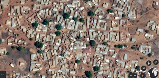
Plate 2. A close view of a neighborhood in Savelugu showing uncontrolled physical development. Source: Google earth image, 2021.
In addition, it was also observed that respondents who did not have vehicular access to their homes built their houses haphazardly without following the layouts of the area. This according to the Physical Planning Unit of the Savelugu Municipal Assembly resulted in the closing up of all demarcated routes in the neighborhoods. Therefore, regulatory authorities in charge of physical development control such as the Municipal Assembly, Land Use and Spatial Planning Authority (LUSPA), Lands Commission, among others, must collaborate with developers to ensure the development activities are regulated to ensure sustainability. The study considered the environment to include both built (brown) and natural environment (green).
5. Conclusions
From the Results and discussion of the data obtained from the field, some conclusions were reached on the main research question, “What is the impact of physical development practices and control in the Savelugu Township?” The conclusion is structured according to the objectives and questions to ensure clarity and easy understanding.
The study sought to assess the awareness level and patronage of development control practices to see if adherence to development control practices could be enhanced. From the field, theory and experience support the fact that adherence to physical development control practices is a significant step towards ensuring a safe environment in every society. However, most developers in the study area were not aware of development control practices. This led to low patronage, which was attributed to the lack of public education. Similar to a study by John (1980) [20] , if the level of awareness is improved, it is likely to have an overall positive impact on the patronage of development control practices.
Also, the study also assessed the physical impact of uncontrolled physical development on the environment. It was found that uncontrolled physical development has made it difficult for the Assembly to extend social and basic amenities to some sections of the town. It has also resulted in environmental challenges since people built their houses on waterways. Therefore, encouraging development to follow laid down rules and regulations and their own individual effort to keep the environment safe can help achieve the objectives of physical development control, as equally opined by Issahaque (2002) [21] .
Again, in assessing the challenges faced by stakeholders in regulating physical development control practices, the study revealed the numerous problems confronting stakeholders (Savelugu Municipal Assembly). There was an institutional collaboration between these stakeholders. Ignorance on the part of developers, bureaucracy and the high cost involved in acquiring permits affected the work of the Assembly, which is also evidenced in the work of Tasantab (2016) [22] . It was also established that logistical and staffing constraints made it challenging for the Assembly to perform its duties effectively. Therefore, these challenges must be seriously looked at through the concerted efforts of stakeholders to ensure that physical development is controlled.
6. Recommendations
1) The Assembly must sensitize the public to help developers understand and appreciate the need and relevance of physical development control in the study area. This can be done through the media, forums and seminars organized by the Assembly, and this must be done regularly to ensure the sustainability of this initiative.
2) The Assembly and other stakeholders must ensure that rules and regulations relating to permits are enforced to the latter since the perceived non-enforcement of the development control practices is also reflected in the quality of the built environment, which was characterized by unplanned settlement and disregard for planning regulations.
3) The Assembly should also make sure that punitive measures are handed down to developers who disregard the required building procedures. Offences such as developing without a permit, and developments that do not conform with the relevant layouts among others, must attract appropriate fines to deter others from flouting the rules.
The central government and the municipal assembly must collaborate to ensure that the staffing levels in the physical planning units and works department of the Assembly are improved to boost their staffing capacity. Also, the necessary logistics must be provided to these units to enable them to effectively perform their duties in a well-controlled physical environment.
Acknowledgements
Thanks to all who contributed in making this paper a success.