Geophysical Investigation of Groundwater Potentials of the Nanka Sand in Obosi and Its Environs, Anambra State Nigeria ()
1. Introduction
Water is an important natural resource that is essential to all lifeforms [1] [2]. Humans require an average intake of 2.5 L of water per day. For domestic purposes, the average volume of water utilized per person is approximately 200 liters daily [3]. Surface water resources are usually easy to access and could serve as the most convenient way to mitigate water crises and demand. Despite the ease of reach of surface waters, they are not dependable as they have a tendency to be evaporated in high-temperate regions and are commonly prone to pollution and waterborne diseases [4], hence making groundwater an appropriate solution to the need for quality water [5]. External pollutants rarely affect groundwater as earth materials serve as a filter for the water that permeates through it [6]. Rock formations that serve as water reservoirs within their pore spaces or fractures are referred to as aquifers. Aquifers may vary in length and width [7]. The different operations in the assessment, development and management of groundwater for distribution as highlighted by [8], include investigation for groundwater, well drilling, development, and well completion. This research work is centered on the pre-drilling geophysical investigation for groundwater.
The rationales delivered by geophysical surveys include the assessment and evaluation of geologic features like groundwater and in situ identification of engineering properties. Effectiveness is a fundamental criterion for every engineering–geological survey [9]; therefore, for a reliable investigation of groundwater, important information regarding the depth, location, and extent of groundwater bearing formation involves the employment of in-depth and effective techniques [8]. The need for pre-drilling geophysical investigation for groundwater is necessary to curb the possibility of drilling dry holes as well as to cancel out any possible expenses from low-quality groundwater production [10]. Geophysical techniques can be categorized as active or passive. While the active methods transmit energy into the ground and measure the feedback, the passive measures constant natural fields. Diverse geophysical methods have been employed in groundwater investigation and have demonstrated commercial success. They may include the radioactivity method, seismic refractive method, magnetic method, electromagnetic method, electrical resistivity method, and gravity method.
This work is characterized by the application of the electrical resistivity method in groundwater investigation. The difference in the resistivity of earth materials is an inherent property that determines the link involving the gradient of the electrical potential and the current density. The disparity in their resistivity differentiates the different rock materials and consequently uncovers the physical properties, thickness, and makeup of the subsurface. In hydrological, mineral exploration, engineering, and archaeological surveys, the electrical resistivity method are among the earliest techniques that have been used [2] [11] [12] while the vertical electrical sounding (VES) turned out to be the commonly used electrical resistivity tool owing to its effectiveness and capability to deliver important information regarding the subsurface at a considerable depth [13]. It deciphers the variation of resistivity with depth which can indicate the presence of groundwater.
2. Description and Geology of the Study Area
The study area lies between latitudes 6˚4'00''N to 6˚7'30''N, Longitude 6˚49'00''E to 6˚53'00''E. The climatic zone is tropical and commonly known for two seasons; the wet season which stretches from April to October and the dry season from November to March. Whilst the wet season is attributed to a period marked by intense rainfall, ground infiltration, seepage, and rise in the groundwater table, the dry season is notable with air masses of low humidity that trigger an increased rate of evapotranspiration and low water levels [14] [15]. The area has an average annual rainfall of 1478 mm, and relative humidity ranging from 60% during the dry season and 90% during the wet season with daily highest and lowest temperatures of 33˚C and 22˚C respectively [15].
Geologically the study area falls within the Nanka Sand belonging to the Ameki Group in the Tertiary Niger Delta Basin. The Ameki Group has been described as a subsurface equivalent of the Agbada Formation [16] [17] and includes the Ameki Formation, Nanka Formation, and Nsugbe Formation [18]. The age of the Ameki Group is known to be Middle Eocene (Lutetian) to Lower Bartonian [19]. It comprises trough and planar cross-bedded sandy shale, shale (bearing fossils and fossil traces like foraminifera, corals, and mollusks), clayey sandstone together with slim bands of limestone [17] [20]. This indicates a heterogeneous environment of freshwater to estuaries and slightly marine [20]. The sandy unit of the Nanka Formation constitutes poorly cemented and loosely packed medium to coarse-grained sand, with a thickness ranging from 50 to 90 m [21], and serves as the water-bearing sediment of the formation [22] [23]. It has its major mineral is quartz (sub-angular to sub-rounded) which is indicative of an incomplete episode of multiple recycling, giving rise to sub-mature sediments texturally and a minor amount of rock fragments.
The study area, due to its weak sedimentary stratigraphy is prone to gully erosion and is home to the most devastating gullies in Nigeria that have wreaked havoc on the local communities. These gullies were induced by both natural (nature of the substratum, climate, topography, and vegetation) and man-made factors (poor agricultural practices like bush burning, overgrazing, ridging along slopes instead of across slopes, dumping of refuse in drainages, poor town planning, etc.) (Figure 1).
3. Materials and Methods
The fieldwork was done using Ohmega System Terrameter, current and potential electrodes, geologic hammer, Garmin eTrex Venture HC—Global Positioning System, ArcMapSoftware, and Google Earth. The first step was to produce a base map with the use of the ArcGIS software and Google Earth; this was done to have a piece of prior knowledge on the accessibility and topography (physiography) of the study area.
Resistivity Sounding (VES) techniques were adopted at various locations in the studied area because of their effectiveness. It gives reliable and consistent
![]()
Figure 1. The lithostratigraphic units in SE Nigeria and their ages (modified after [18]).
information on the changes in subsurface layering, and in the structural trends of the lithology. [24] confirmed the suitability of this method in the investigation of groundwater. It works on the basis that the spread of electrical potential within the earth around an electrode carrying current is dependent on the electrical resistivity and the arrangement of the sediments. Using two metal electrodes, a direct current (DC) is sent into the earth. While current moves from an electrode to an electrode and considering that earth materials give certain resistance to the flow of current, some voltage is lost. The potential electrodes positioned in between the current electrodes measure the loss in voltage. As the electrodes are spread apart, the deeper the depth of investigation and the resistivity acquired at a particular electrode position represent the mean resistivity values above the effective depth of investigation.
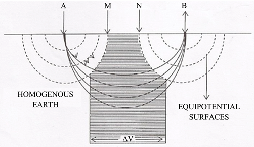
Equipotential and current lines for a pair of current electrodes A and B on a homogeneous half-space [25].
15 VES stations were established at the site using Schlumberger electrode configuration with current electrode spacing (AB/2) of 350 meters. [26] confirmed the accuracy of this configuration in groundwater investigation and it’s fairly low-cost field-based activities and setup. While [27] have proven that the configuration’s Depth of Investigation (DOI) for every current electrode spacing is quite high. The geologic parameters such as the number of geo-electric layers, the thickness of the geo-electric units, and their resistivities were interpreted from the VES curves. A qualitative assessment of the curves shows that a model with 5 layers would sufficiently model the field curves. Quantitative interpretation of field curves involved inversion with appropriate parameters using Zond Res1D software.
4. Discussions and Recommendations
The investigation intends amongst others to assess the groundwater potential of the area, find out the existence of possible aquifer(s) within the area, and estimate the possible depth of a borehole. The study area was selected because of the rapid urbanization and the ever-rising demand for clean water for their day-to-day and commercial activities owing to the low yield and failure of neighboring wells notably during the dry season.
The representative VES interpretation model results from the 15 VES points and the VES map from the 4 locations are shown in Figure 2 and Figure 3 respectively. These include Obosi, Umuoji, Oba, and Ojoto all within the Nanka Sand belonging to the Ameki Group in the Tertiary Niger Delta Basin. This formation comprises very weak sandstone facies, which are poorly cemented and loose, especially on or near the earth’s surface. Assessing the facies suggests an environment that may have resulted from freshwater to estuaries and slightly marine.
The analysis and interpretation of the geophysical data gathered from the study area indicated an area delineated by five (5) main geo-electric layers that are possible for groundwater development, with thickness values from 0.1 to 86 m, resistivity range from 258 to 13,258 Ωm, and depth range of 1.2 and 109 m.
On due consideration and finding, it is recommended that for effective borehole sitting, a drilling depth of 103.7 meters (340 feet) deep borehole will thrive within the area, the use of a standard drilling rig capable of achieving the recommended depth and geophysical logging of the borehole before installation of casing and screens.
5. Conclusion
The groundwater potentials of Nanka Sand in Obosi and Its Environs, comprising Obosi, Umuoji, Oba, and Ojoto have been evaluated by the use of a combined methodology encompassing both geological and geophysical investigations.
![]()
Figure 3. The geologic map of the study area indicating the different towns and the VES locations.
The geology of the area falls within the Nanka Sand belonging to the Ameki Group in the Tertiary Niger Delta Basin and is known to be poorly cemented and loosely packed medium to coarse-grained sand. Resistivity Sounding (VES) techniques were adopted at various locations in the area. 15 VES stations were established at the site using Schlumberger electrode configuration with current electrode spacing (AB/2) of 350 meters and showed mainly 5 geo-electrical zones. The analysis and interpretation of the geophysical data gathered from the study area in combination with its known geological characteristics indicate that the area is viable for groundwater development and have provided adequate background information on the existence of aquifers within the area and an estimate of the possible depth of a borehole.
This paper is expected to assist geo-technicians, water resource planners, and decision-makers in effective borehole sitting and drilling within Obosi and its environs.
Acknowledgements
We would like to thank Essbee Geotechnical Ventures for giving us all the necessary equipment, advice, and support. Again to the local authorities within Obosi, Umuoji, Oba, and Ojoto for granting us access to carry out our investigations.