1. Introduction
Information systems are composed of processes for collection, organization, storage and communication of information. For information to be authoritative it is necessary for the receiver to establish a) the source of the information, and that b) the source does indeed have the authority to convey the information. Most often, the authority is gained through a chain of delegations. For information to be unbiased, it is necessary to establish that no relevant information was suppressed.
A well known example of an authoritative unbiased (AU) service is the Domain Name System (DNS) [1]. When used in conjunction with the DNS security protocol DNSSEC [2], DNS provides AU assurances for responses to DNS queries. DNSSEC makes it possible to establish that (for example) the IP address of a domain name cs.ms.edu did indeed originate from the authoritative DNS zone ms.edu. Furthermore, in response to a query for information regarding a non-existent name (say) xyz.ms.edu, the response will provide proof of nonexistence.
In geographical information systems (GIS) [3], different types of information may be associated with various geographic objects like a point1 (x,y), or a line segment connecting two points, or all points inside a polygonal region. Currently, while service providers do exist for providing useful geographic information (like one’s location, restaurants and other services nearby, zip code corresponding to a location, current weather at a location, etc.), such services can not be considered as AU—as we are required to trust the service provider. The main contribution of this paper is a comprehensive Authoritative and Unbiased Geographic Services (AUGS) protocol, for guaranteeing AU responses from untrusted service providers, to geographic queries.
Organization
The rest of this paper is organized as follows. Section 2 provides a broad overview of the goals of AUGS. This is followed by a comparison of the goals of AUGS with that of the DNS protocol for domain names. In particular, we point out some of the unique challenges faced by AUGS due to the fact that the definition of a “geographic region” is substantially more complex than that of a “name.” The former is a list of (x,y) coordinates on a 2-D plane, while the latter can be considered as a point on the number line. It is argued that the challenges can be overcome by using Merkle hash tree based authenticated data structures (ADS) in conjunction with a blockchain ledger.
Section 3 illustrates with examples, 2 core AUGS processes, viz., map-construction, and map-update. Both processes are described in terms of simple steps involving incremental changes to AUGS data. Such simple steps are blockchain transactions that modify AUGS data. Section 4 describes a family of ADSes for computing/tracking a dynamic cryptographic commitment to different types of data. Section 5 illustrates the use of such ADSes for AUGS specific data like “list of boundary lines,” “set rectangular bounding blocks,” “set of points,” and key-value pairs, etc. Section 5 also outlines different types of blockchain transactions that trigger incremental updates to AUGS data, and consequently, the ADS commitments. Finally, Section 5 outlines the steps involved in verifying AU properties of responses to queries.
A discussion of related works and conclusions can be found in Section 6.
2. AUGS Overview
A geographical region [4] can be described as a simple2 n-sided polygon, where the sides of the polygon are n-boundary line segments.
More generally, a geographic region R may be a set of simple polygons—some that enclose region R, and some that exclude region R. In Figure 1(a), regions R2, R3 and R4 are represented by a one polygon each. Region R1 is described by 3 polygons—two enclosing polygons (shaded light gray), and an exclusion polygon (darker gray region R4). For a geographical region R defined by q1 inclusion polygons and q2 exclusion polygons, the region R lies to the left on counter clockwise (CCW) traversal of points in the q1 polygons that enclose R (and to the right in q2 polygons that exclude R).
In the rest of this paper we assume that a region is expressed as a list of boundary lines of the form
where
represents point coordinates, and m uniquely identifies one of the many simple polygons of the region to which the boundary line belongs. We shall further assume that m is odd for inclusion polygons, and even for exclusion polygons.
AUGS regions may be reshaped by adding new lines. For example, by adding new lines, a polygon representing a country may be subdivided into smaller polygons representing states. Most often, the reason for creating subdivisions are for purposes of delegation of authority.
A region may be associated with different types of static and dynamic attributes like zip code, name, voting precinct, tax rates, zoning restrictions, weather information, etc. AUGS should enable anyone to
1) query such information regarding any point (x,y),
2) establish the source, and
3) establish the authority of the source (typically gained through a chain of delegations).
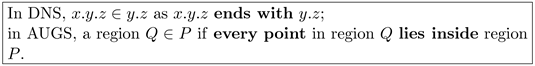
2.1. DNS vs AUGS
The Domain Name System (DNS) [1] is a protocol for hierarchical delegation of a name-space. A delegated DNS name is a DNS zone. Ownership of a DNS zone (for example) ms.edu is acquired through delegation by the parent zone edu, which was in turn acquired by delegation, from the root zone.
In this paper we shall use the notation
to signify that “a is a child of b.” For example, in DNS ms.edu
edu (as ms.edu is a child of edu).
The owner of ms.edu can create any number of child names ending with ms.edu—for example, cs.ms.edu, ee.ms.edu, etc. Newly created names can be i) associated with different types of information—by creating different types of DNS records, or ii) delegated to create a new zone—by creating a special DNS record of type NS.
Analogous to a zone name in DNS, is a region (described by 1 or more simple polygons) in AUGS. An important difference between the DNS and AUGS is as follows:
An AUGS region P can create any number of non overlapping child regions. A region P can delegate a child region (say)
, or associate different types of information with any point inside P, or any line segment inside P, or any polygon
.
2.2. AU DNS Responses
DNSSEC [2] associates every DNS zone with a public key. The public key of zone
is certified by the parent zone
, whose public key is certified by its parent zone z, whose public key is certified by the root zone (say,
). The public key of the root zone is assumed to be public knowledge. In the rest of this paper, we shall use the notation
for “certification of public key of A by S.”
Knowledge of the root public key is sufficient to track the authority of the public key of any zone Z, by following a chain of delegations. That public key UZ is authoritative for a DNS zone Z implies that all DNS information certified using UZ is authoritative for names that end with Z—but only as long as such names have not been delegated. For example, the public key U of ms.edu is not authoritative for the name dis.cs.ms.edu if either the name cs.ms.edu or the name dis.cs.ms.edu have been delegated.
The response to a DNS query is a DNS record, along with a signature for record (signed by the zone under which the name falls), and records needed to verify the delegation chain. The steps necessary to establish AU properties of a response
for a name (say) n that falls in zone A where (say)
are as follows:
1) verify certificate
(DNS record
signed by zone A),
2) verify delegation chain
,
, and
,
3) verify that i) name n ends with A; ii) name A ends with B, and iii) name B ends with C,
4) if n ends with A, but
(for example, A = cs.ms.edu, but n = se.cs.ms.edu) establish that name n has not been delegated by A.
The last step, viz., proof of non-existence of delegation records—or authoritative denial—is facilitated by the NSEC/ NSEC3 [5] [6] component of DNSSEC. Authoritative denial also serves to guarantee unbiasedness of DNS. The need to prove non-existence implies that the responder (untrusted DNS servers) will not be able to (accidentally or deliberately) hide the existence of a queried DNS record.
2.3. AU Geographic Responses
Now consider the AUGS scenario with hierarchical region delegations
. The steps necessary for verifying the authoritativeness of some information
regarding a point
are as follows:
1) verify certificate
for the information provided;
2) verify the delegation chain
,
,
;
3) verify a) that
; b)
, and c) and
, and
4) ensure that every point/region is uniquely delegated.
The first 2 steps (verification of certificates) are similar in both (DNS and AUGS) scenarios; both involve verification of
certificates (does not depend on N, the total number of DNS records/AUGS data items). The third and fourth steps are however substantially different. While it is trivial for the DNS verifier to determine that “a name a ends with b” it is far from trivial in the AUGS scenario to determine if
; it is even more difficult to determine that region
(or all points in region A fall inside region B). This is especially true in scenarios where regions may have tens of thousands of sides3, may be defined by multiple polygons, and may include other delegated sub-regions.
The point location problem, viz., determining if a point (x,y) lies inside a polygon A, is an important problem for several application scenarios, like mouse tracking, computer graphics, GIS etc., and has attracted substantial attention in the literature [8] [9] [10] [11]. However, these algorithms were not designed with the goal of being executed as blockchain transactions. Furthermore, the problem of determining if all points inside a polygon A lie inside a polygon B has not attracted much attention.
Even if efficient algorithms can be designed, they can never have a complexity less than
for a polygon with N sides. Unlike the DNS scenario where it is trivial for the verifier to determine that (for example) msu.edu ends with edu in the case of AUGS, the verifier will first need to access to the N coordinate values, and execute various point-location algorithms to establish that
,
,
, etc. This is obviously impractical for an average information querier. This is the central challenge addressed by the proposed protocol, by taking advantage of i) hash tree based authenticated data structures (ADS), and ii) blockchain transactions that perform simple incremental changes to ADSes.
In the proposed AUGS protocol, verification of AU properties of any query regarding a point in a region with N sides will require only
hash operations to be performed by the verifier. More specifically, if the service provider provides information regarding M different regions, the size of the proof will be
hashes.
The broad goal of the AUGS protocol is to permit anyone to obtain the authoritative public key U for any point (x,y) in the globe. Towards this end, the verifier will need the ability to verify that
1)
, where R is an AUGS region;
2) (x,y) does not fall in a sub-region
that has been delegated by R; and
3) U is the public key of region R.
By leveraging the public key U, any information from the authoritative source for point (x,y) can be verified.
2.4. Overview of AUGS Protocol
Authenticated data structures [12] - [17] enable incremental computation of a succinct cryptographic commitment
to dynamic data
. Prover-verifier protocols that leverage ADSes can be used to efficiently prove specific properties4 regarding the data
to verifiers. Specifically, for an ADS with N data items, untrusted provers will need to provide
verification objects (VOs) as proof. Verifiers, who trust only the current dynamic commitment
to the ADS, will need to perform
hash operations to verify the proof. One novelty of the proposed approach is in utilizing a blockchain network to maintain universal consensus on ADS commitments.
For our purposes, a blockchain network [18] [19] [20] [21] is a distributed infrastructure to maintain an append-only blockchain ledger. Incentive mechanisms in the distributed infrastructure ensure that only well-formed transactions can be added to the ledger. The precise definition of “well-formed” will depend on the application. As an example, in crypto-currency applications that cater for transferring coins between crypto-wallets, a transaction to (say) “transfer n coins from wallet A to a wallet B” will be considered as well-formed only if
1) the transaction is signed by A and
2) A had n or more coins before the transaction was executed.
By ensuring that only well-formed transactions can be added, the integrity of current balances in all wallets is assured.
Execution of a transaction changes the state of the application. For crypto-currency applications, the “current state” can be described by the remaining balance in every wallet. Transferring coins from A to B changes the state of the application (wallet balances in A and B will need to be updated). In blockchain networks like Bitcoin, the state change caused by a transaction is not explicitly indicated in the transaction added to the ledger. On the other hand, in the Ethereum network, a cryptographic commitment to the new state(s) is made explicit in ledger entries.
In the proposed approach, processes composed of simple blockchain transactions will need to be executed by untrusted AUGS service providers to construct and update “maps.” More specifically, a map construction process will involve converting a region represented by a list L of boundary lines, to a “map” B composed by a set of rectangular bounding boxes (BBs). A map update process will involve modifying the map B to incorporate a child region represented by a list of boundary lines Lc, and adding “legend” entries to BBs in the map to identify points inside the sub-region.
On successful completion of such processes, an AU response to any query regarding any point (x,y) is a single BB from the set B.
Specifically, for a region defined by N boundary lines, the service providers will need to successfully execute
blockchain transactions that update AUGS data like L and B. Such transactions will be considered well-formed only if they satisfy a well-defined set of constraints C. The constraints C ensure that untrusted service providers cannot successfully execute map construction/update processes in a way that leads to misleading/incorrect responses to queries.
The dynamic commitment to AUGS data like L and B are captured by hash tree based ADSes. The response from AUGS service providers (which is typically a BB from B) will be accompanied by a “proof” in the form of a small number of VOs (hashes) that can be verified against commitments in the blockchain ledger.
3. AUGS Processes
In this section we will illustrate with examples, two core AUGS processes, viz., map-construction, and map-update.
3.1. Map Construction
The AUGS map-construction process converts a list L of boundary line segments representing a region, into a collection of rectangular bounding boxes (BBs). For simplicity we shall first assume a region defined by a single polygon, represented by a list
. The map construction process attempts to move every boundary line in a list L to a rectangular BB in the collection B of rectangular BBs, such that the every boundary line falls wholly inside a BB. Towards this end, the process is allowed to perform simple operations like
1) split any boundary line in L into 2 segments (thereby increasing the total number of lines by one),
2) split any BB in B (horizontally or vertically, thereby increasing the total number of BBs by one), and
3) move a boundary line from the list L to an appropriate BB in B, subject to constraints C (to be discussed soon).
Each such operation is executed as a transaction in a blockchain network. Such transactions will be considered as well-formed only if they satisfy the constraints C, viz.,
C1. at most 2 boundary line segments can fall inside a BB;
C2. a single line mapped to a BB can only be a side or a diagonal of the BB;
C3. if 2 boundary line segments fall inside a BB, one should be a diagonal; the other should be an adjacent boundary line;
C4. redundant boundary points should be unique;
C5. mapping should be performed in the CCW order of points;
C6. if 2 adjacent boundary lines are mirror images of each other both lines should be removed from L and ignored.
Redundant boundary points are points that do not affect the enclosed region. Given two adjacent boundary lines
and
, the point
is a redundant point if
lies on the line connecting
and
. While such points are created by splitting boundary lines, it is possible for such points to exist even in the input (the list L) to the process.
Mirror images of 2 adjacent boundary lines
, and
where
may be (as we shall see in Section 3.3.2) due to finite precision.
It is important to remember that service providers are not trusted, and might attempt to create invalid regions for deliberately misrepresenting information. The ability to include mirrored boundary lines and duplicate redundant points can be used by provers to misrepresent map legend entries in BBs. The 6 restrictions C1 ∙∙∙ C6 ensure that the map-construction process can be successfully executed only if the input L to the process corresponds to a simple polygon. The justification for the constraints are outlined in Section 3.3.
On successful completion of the process, the collection B of BBs will consist of some BBs with no lines, some with one line, and some with 2 lines. More specifically, the resulting BBs can be of up to 14 types as depicted in Figure 1:
1) type 0 with no lines (clear BBs);
2) types 1 and 2 with a single diagonal line (blue BBs);
3) types 3 to 6 where the line mapped to a BB is a side of the BB (green BBs), and
4) types 7 to 14 (red BBs) where 2 adjacent boundary lines are mapped to a BB—where one is a diagonal; the shorter line (between a side and a diagonal) is associated with an offset o; the offset
if the shorter line is a BB side.
That no more than 2 lines can be mapped to a BB, and that the lines can not cross each other inside the BB, implies that areas within a BB can belong to at most 3 different regions, captured by 3 region legends
and
. Enforcing CCW order of mapping boundary lines to BBs is to ensure unambiguous labeling of regions
and
inside each BB. Recall that for enclosing polygons the triangular/rectangular area to the left is inside the region; for exclusion polygons the area to the right is inside the region. The legend entries
and
will be 0 for areas outside the region and 1 for areas inside the region.
After completion of the map-construction process, a query regarding any point (x,y) can be answered by responding with a single BB in which (x,y) falls, and examining the region markings inside the BB.
3.2. Map Construction Example
To keep the discussion simple, we shall first limit ourselves to regions defined by a single polygon. Consider a polygonal region described by a list of boundary lines {AB, BC, CD, DE, EF, FA} in Figure 2(a), bounded by a dashed rectangular bounding box (BB).
By repeated use of appropriately chosen simple operations that split a boundary line into 2 (creating a redundant boundary point), and split a BB into 2 (vertically or horizontally), we can fit every boundary line as a side or a diagonal of a BB (Figure 2(b)). For the region with 6 boundary lines in Figure 2 we
1) split boundary line AB into AE' and E'A (adding a redundant boundary point E'), and
2) perform 8 BB splits (to result in 9 BBs marked 01 to 09), and
3) map boundary lines to BBs while strictly adhering to all constraints.
In this particular instance, 5 boundary lines become diagonals of BBs; 2 lines become a BB side; two BBs (05 and 06) are empty.
As a second example, consider a region (Figure 2(c)) PDQ. In this instance, we
![]()
Figure 1. (a) Four geographic regions R1, R2 and R3 and R4; (b) An illegal region defined by a non-simple polygon ABCD (sides BC and DA intersect at E); (c)-(e) Effect of finite precision. Type 0 to Type 14: 15 BB types (
).
![]()
Figure 2. AUGS points and bounding boxes (BBs). (a) Parent region; (b) AUGS BBs for parent region; (c) Child region; (d) AUGS BBs for child region; (e) Altered parent region to incorporate child.
1) create a redundant boundary point Q' to split boundary line PD into PQ' and Q'D;
2) perform 3 BB splits; and
3) map boundary lines to BBs.
This time however we have to map two boundary lines (QP and PQ') to the same (red) BB (Figure 2(d)). Mapping 2 boundary lines inside a BB is unavoidable in situations where projections of adjacent boundary lines overlap in both X and Y directions.
On successful completion of the map construction process, any query regarding any point (x,y) inside the original dashed BB can be answered by examining a single BB (in the BB collection). Each BB conveys coordinates of up to 2 lines, and up to 3 region codes, from which it is straight forward to determine the region code for point (x,y).
For the first example the region code corresponding to line BC mapped to BB 06 in Figure 2(b) will indicate that the region above the line is 1 and the region below as 0. The red BB in Figure 2(d) will be associated with 3 region codes—0 for region below PQ', 1 for region below PQ (and above PQ'), and 0 for region above PQ.
If the query point (x,y) lies inside a clear BB, it is sufficient to examine an additional non-clear adjacent BB. For example, for a point (x,y) in BB 07, the region code is the same as the region code below the diagonal of BB 06 to the left, or below the diagonal of the blue BB 08 above.
3.3. Rationale for the Constraints
The map construction process is deemed successful only if all boundary lines are mapped to BBs. The 6 constraints ensure that only a sequence of points/sides representing a simple polygon can lead to successful completion of this process.
Constraint C3 ensures that boundary line segments cannot cross inside any BB. C4 ensures that lines do not cross at BB corners. Constraints C5 and C6 ensure unambiguous labeling of triangular/rectangular areas inside BBs.
To see the need for the constraint of uniqueness of redundant points (C4), consider the non-simple polygon represented by 4 lines {AB, BC, CD, DA} in the Figure 1(b), which obviously does not describe a valid region. Nevertheless, by splitting boundary lines AB at A', BC at E, CD at D', and DA at E, all resulting boundary lines (AA', A'B, BE, EC, CD', D'D, DE and EA) of this obviously invalid region can be mapped to BBs—as the boundary lines do not intersect inside any BB. However, the redundant points A', E, D' and E are not unique (as E occurs twice). This constraint will cause the map-construction process to fail.
Note that the situation would be different if the same region was described instead by a list of six boundary lines {AB, BE, ED, DC, CE, EA}. In this case only 2 redundant points will need to be added (A' and D'), to map all boundary lines. Mapping this sequence of boundary lines will be successful this time—as it should be, as the boundary lines do describe a valid region (two triangular regions meeting at E). While we have 2 instances of point E, they are not redundant points in this case.
3.3.1. CCW Mapping
The constraint of CCW order is to ensure unambiguous assignment of region codes. Specifically, the region to the left/right of the line is labelled 1/0 for enclosing polygons (0/1 for excluding polygons). On completion of the mapping, the BB coordinates, BB type, 3 region labels, and offset o (for BB types 7 to 14 in Figure 1) are sufficient to unambiguously determine the precise coordinates of lines mapped to the BB, and consequently, determine the region legend for point (x,y) (1 for inside the region and 0 for outside). To ensure that the mapping is sequential it is verified that the next line starts where the last mapped line ended. To ensure that the order is CCW (and not CW) the area of the polygon is incrementally computed using the shoe-lace formula [22]. As every line is mapped sequentially, only CCW mapping will result in a positive value for the area (CW mapping will result in a negative value).
The “shoelace area” A is initially set to 0; if a line segment
is added to the map the shoelace area is incremented by
. On completion of the mapping, the cumulative shoelace area5 A will be positive only if the traversal in performed in CCW order. If
the process is considered to have failed (the ill-formed transaction will be rejected).
3.3.2. Implications of Finite Precision
There are obviously scenarios where it is necessary to map 2 lines to a BB (when 2 adjacent boundary lines have overlapping projections in both X and Y directions). Fortunately, even for maps with multiple polygons 2 lines to a BB is sufficient.
Consider a scenario in Figure 1(c) where several boundary lines meet at a corner of a BB. It might appear at first glance that how many every subdivisions are performed to split boundary lines or BBs, a BB at the lower left corner, at which all lines meet, will still have more than 2 lines mapped to it.
In practice, however, only a finite number of bits can be used to represent x and y coordinates. For example, representing coordinates using unsigned 32-bits is sufficient to realize a worst case resolution error (at the equator) of about 1 cm. With finite precision, in the smallest possible BB
at the lower left corner, all lines will have to map to the bottom side or the diagonal, or the left side of the BB (Figure 1(d)). In other words, at most 3 lines may need to be mapped to a BB.
However, we have the option to map the bottom of the BB as the top side of the BB below, or the left side as the right side of the BB to the left. In the worst case scenario, only 8 lines will need to be mapped to 4 adjacent BBs (Figure 1(e)).
An important consequence of finite precision is in scenarios where boundary lines meet at a point (say
) at highly acute angles. Let the two adjacent lines
,
fall inside the same BB, where
and
have the same x-coordinate (where they meet a BB side). If the y coordinates of the two points differ by less than half the smallest BB resolution, then
and
will be quantized to the same point
, thereby creating two adjacent boundary lines
and
, that mirror each other, creating a zero-area region between them. Mapping such lines will result in inconsistent region codes. Fortunately, removing such lines (and not mapping them) will have no practical effect on the geometry of the region. Such adjacent pairs, if present (either due to precision issues, or deliberately added by untrusted provers), will be ignored.
3.4. Map Update
The map-update process modifies the map of a region (created by a map-construction process) to include a sub-region. This process may need to split BB’s created by the map-construction process further, add new lines inside BBs, and update legend labels for areas inside BBs. While region label 1 is used for the region created by the map construction process, region codes 2 and higher are used for labeling sub-regions created by the map-update process. This process can be performed any number of times to create any number of non overlapping child regions, with unique region legend labels.
Consider a scenario in Figure 2(e) where the polygon PDQ in Figure 2(c) is actually a child of region ABCDEFA in Figure 2(a). In this specific case, by further splitting BBs 09 and 08 in Figure 2(b) as in Figure 2(e) we can incorporate the second region too in the map of the first region. More generally, the map update process can be seen as consisting of the following steps:
1) Move some existing lines from some BBs in the parent map to a temporary list; in this case lines ED (BB 09 in Figure 2(b)) and CD (BB 08 in Figure 2(b)) will be moved to the temporary list.
2) Split (now empty) BBs as necessary; in this case BB 08 in Figure 2(b) was split into 4 BBs (08, 13, 14 and 15 in Figure 2(e)); BB 09 in Figure 2(b) was split into 5 BBs (09, 10, 11, 16, 12 in Figure 2(e))
3) Split lines in the temporary list as necessary; line CD was split into CP and PD; line ED was split into EQ and QD.
4) Map all lines from the temporary list back to BBs; 4 lines CP, PD, DQ and QE will be re-mapped (to BBs 08, 14, 12 and 09 respectively, in Figure 2(e)).
5) Split boundary lines of the child polygon as necessary; QP was split into QR and RP.
6) Map all child boundary lines to the altered parent’s map, one by one, in CCW order, and update region codes as necessary.
If the legend index assigned to the child is 2, on completion of the map update process the region codes in BBs 12 will be
,
(region
not present in blue BBs). In BB 16 the region code will be
,
; in BB 14 the region codes will be
,
,
.
As the child boundary lines are mapped to BBs of the parent, the region codes to the left of the line (or right of the line for island polygons) are modified from “1” to the unique legend label (for example, 2) assigned to the child.
As mentioned earlier the list of boundary lines L and set of BBs B are hash tree based ADSes outlined in the next section.
4. Authenticated Data Structures
Given a cryptograpic hash function h(), and
(1)
it is safe to conclude that “pre-image x existed before hash y.” This is due to the fact that if y were chosen first it is computationally impractical to come up with a suitable pre-image.
Cryptographic hash functions lie at the core of several hash tree based ADSes that enable incremental computation of a succinct cryptographic commitment
to dynamic data
.
In prover-verifier protocols that leverage such ADSes, irrespective of the number of items N in dynamic data
, it is sufficient for the verifiers to track a single dynamic hash
. Provers (who actually store all data
) can prove specific properties of the
to verifiers by providing
VOs. The verifiers, who do not trust the prover, can verify the proof by performing
hash operations and comparing the result with the current commitment
.
4.1. Ordered Merkle Trees
A binary Merkle hash tree [23] of depth d can have up to
leaves and
nodes. Each leaf is a data record. The N leaf-nodes at depth d are leaf hashes; the N/2 nodes at depth
are obtained by hashing 2 nodes in depth d together, and so on. The 2 nodes at depth 1, are finally hashed together to result in a lone node—the root of the tree—at depth 0. The root is a commitment to all leaves and nodes.
Corresponding to any node v at depth k are k complementary nodes
—one each at depths
. The complementary nodes are VOs that permit any entity with access only to the root
of the tree to verify existence of node v, at depth k, in a tree with root
. Proof of existence of a leaf-node is proof of existence of its preimage, viz., a leaf. By performing
hash operations using
VOs, a verifier with access to the root can verify the existence of any leaf in the tree, and/or compute the new root corresponding to an incremental update like a) modification to a leaf, or b) insertion/deletion of a leaf.
Unfortunately, the Merkle hash tree does not enable the prover to efficiently prove absence of a specific leaf/record. This limitation is addressed by ordered Merkle trees (OMT) [14] [15] which imposes well defined rules for insertion/deletion of leaves. The rules for insertion/deletion guarantee completeness of the collection represented by leaves of the tree, at all times.
Each leaf in an OMT corresponds to an interval on the number line. An interval/leaf
represents
1) (if
): all
;
2) (if
): all
and all
(note that if
the interval represents the entire number line
and all
).
Leaves can be inserted only by splitting an interval into 2—thereby, replacing a leaf with 2 leaves. Merging 2 adjacent intervals results in removal of a leaf. These restrictions ensure that leaves of an OMT form a complete collection at all times. More specifically, a unique leaf will exist for every point on the number line.
The first leaf inserted into an empty OMT will correspond to an interval
(all values greater than equal to x and all values less than x). To create a new interval from x to y where
we can split the leaf
into 2—one corresponding to the desired interval
and the second corresponding to a wrapped around interval
. As an example, the 3 leaves
,
and
for a complete collection.
An OMT can also be interpreted as a key-value collection. With this interpretation, the start k of an interval
is seen as a unique key. Under this interpretation, existence of a leaf
in a hash tree with root
implies
1) existence of a key-value pair
; and
2) that the next-key is
implying non-existence of all other keys that fall in the interval. Note that if
, then x and
are the highest and lowest keys (respectively).
Thus, by demonstrating the existence of a leaf, the prover can now demonstrate non-existence of specific keys, highest/lowest keys, etc. Elementary OMT operations like insertion, deletion, and leaf updates have the same
complexity as Merkle tree operations.
4.2. 2-D OMT
One important contribution of this paper is a 2-D extension of OMTs. A 2-D OMT can be seen as a complete collection of 2-D intervals (or bounding boxes) of the form
. Specifically,
represents a planar rectangular region extending between
in one dimension and between
in the second dimension. A collection with a single BB will specify a wrapped around interval
representing the entire 2-D plane.
The first leaf (BB) inserted into an empty 2-D OMT should be of the form
, (representing the entire 2-D plane). A leaf for interval (say)
can be split into two (for example)
1) horizontally as
and
, where
, or
2) vertically as
and
, where
.
A leaf for a wrapped around interval
may be split
1) along a vertical into
and
where
or
; or
2) horizontally as
and
where
.
For our purposes, leaves of a 2-D OMT are five-tuples that convey the four values
(BB coordinates), and a value v associated with the BB. A 2-D OMT is guaranteed to include a leaf for every point
on the plane. More specifically, a query regarding any point
on a plane can be answered by providing a single leaf from a 2-D OMT (along with
VOs, where N is the total number of BBs).
5. Process States and Transactions
AUGS employs a variety of Merkle tree and OMT based data structures to compute dynamic commits to AUGS process states.
5.1. Process States
AUGS process states that are incrementally updated by AUGS transactions are as follows:
1) region data: leaves of a Merkle tree with commitment
;
2) map data: leaves of a 2-D OMT (BBs) with commitment
;
3) redundant-points: a key-value collection with commitment
; and
4) temporary-lines: leaves of a Merkle tree with commitment
.
For simplicity of notations, in the rest of this paper, we will use the following conventions:
1) A collection (leaves of a hash tree with root
) will simply be referred to as “collection
.”
2)
implies “a leaf L in collection
.”
3)
indicates “key k does not exist in collection
.”
5.1.1. AUGS Regions
An AUGS region (composed of one or more polygons) consists of boundary lines of the form
where i) m is a polygon identifier; and ii)
and
are the start and end points of a boundary line (when the polygon is traversed in the CCW order). The polygon identifier m is odd for polygons that enclose the region and even for polygons that exclude the region.
Each boundary line is a leaf of a hash tree with root
. A region described by u polygons, each with
sides respectively, is a tree with
leaves.
Transaction SplitLine
splits a line
into
and
, only if p lies on
. This operation replaces one leaf with 2.
Transaction SkipLines (
) removes two adjacent boundary lines
and
that are mirror images.
5.1.2. AUGS “Map”
An AUGS map is a complete 2-D OMT collection with root
. A leaf
in this tree represents a rectangular bounding box (BB). The value v assigned to a BB depends on the line(s) mapped to the BB, and is of the form
(2)
where c is the BB type,
are region codes, and o is an offset.
Transaction SplitBB() splits an empty BB in
into 2 (vertically or horizontally). If
, then this transaction sets
corresponding to a lone BB that spans the entire 2-D plane.
5.1.3. Mapping Lines and Redundant Points
The hash tree with root
is a key-value collection where each key corresponds to a (redundant) point, and the value is unused (and thus, omitted). Leaves of this tree are of the form
where
,
. Points determined to be redundant are added to this collection by a transaction MapLine(). This collection is used to guarantee uniqueness of redundant points (as keys have to be unique).
Transaction MapLine(
) i) removes a boundary line
and maps it to a BB in
by updating the value v of the BB and ii) if
is determined to be a redundant point, adds key
to collection
. Transaction MapLine will be ill-formed if the redundant point already exists in
.
5.1.4. AUGS Temporary Boundary Lines
The hash tree with root
is used to temporarily store some boundary lines during the map update process. Leaves of this tree are of the form
and convey region codes above and below the line
(for vertical lines
is the region code to the left).
Transaction UnmapLine() removes (up to 2) existing lines from a BB
, sets the value of the BB b to indicate BB type 0, and adds the line(s) to the tree with root
.
Transaction SplitTmpline(
) splits a line
into
and
(only if p lies on the line segment
).
Transaction RemapLine() removes a line from
and maps it back to a BB in
(and updates the BB type and region codes).
5.2. Macro-Transaction ConstructMap()
The state of a map construction process is captured by seven dynamic values, viz.,
(3)
where
is the commitment to a region (with any number of polygons),
is the commitment to a map,
is a commitment to a collection of unique redundant points.
Tracking the 3 point values
, and the “shoelace area” A, makes it possible to i) identify redundant points and mirrored boundary lines ii) ensure that all polygons in
are closed; and iii) ensure that traversal was performed in the CCW order. All 4 values are affected by the MapLine (
) transaction.
The shoelace area A is initially set to 0. As a line
is added to the map where
,
,
and
are the respective coordinates of
and
, the elemental shoelace area is
(4)
On completion of the mapping the cumulative shoelace area6 A will be positive only if the traversal in performed in CCW order.
If
the implication is that the line
to be mapped is the first line of polygonm in
. Consequently,
is initialized to
(and will be reset to 0 when a line
is mapped). In addition, all leaves in the tree
(redundant points) are removed by setting
. The values
and
are set to
and
(end points of the most recently mapped line).
If
, MapLine (
) expects
, and
. Recall that scenarios (involving two adjacent lines of the form
and
) can only be handled using transaction SkipLines. If
lies on the line
,
is a redundant point, and should be added as a key to
. Inability to do so (if
already exists in
) will result in failure of the transaction. If
MapLine recognizes end of the current polygon and sets
. The pseudo-code for transaction MapLine() is depicted in Figure 3.
![]()
Figure 4. Micro transaction MapChildline().
The map construction process can be seen as a macro-transaction, consisting of a sequence of micro transactions of 4 types: viz., SplitLine, SplitBB, and MapLine, and SkipLines().
The macro transaction ConstructMap (
) constructs a map (with commitment)
for a region (with commitment)
, by performing a sequence of micro-transactions specified as leaves of a hash tree with root
. The commitment
to the region (root of a Merkle tree with boundary lines as leaves) also serves as a unique region identifier.
The initial state of the process is set to
(5)
From this point onwards, the micro-transactions in the Merkle tree with root
are executed sequentially to split lines in
, split BBs in
, remove mirrored lines from
, and map lines in CCW order to
. At the end of the process,
(implying that all lines have been mapped) and
(the last polygon is closed). In other words, the macro-transaction is well-formed if
1) every micro-transaction in
is well-formed, and
2) the final state is
(6)
On successful completion of the process the region
is determined to be valid, and is associated with a map (with root)
.
5.3. Macro-Transaction UpdateMap()
The state of the map update process is captured by five values, viz,
(7)
where
is the commitment to a child region (which has already undergone a map-construction process),
is the commitment to the map of the parent region, and
is a commitment to a collection temporary lines. As earlier,
is the first mapped point of a polygon in
, and
is the end point of the previously mapped boundary line.
UpdateMap (
) modifies a map
to
to incorporate a child region
, using a sequence of micro-transactions in a hash tree with root
. The value n is legend label to be assigned to the child region.
Seven types of micro-transactions are used by the map update process: SplitLine, SplitBB, SkipLines(), UnmapLine, SplitTmpLine, RemapLine, and MapChildline. The initial state of the process is
(8)
From now on, the micro-transactions remove lines from
and map them to
, split lines in
as necessary, split BBs in
, and finally, map lines in
to
, in CCW order. At the end of the process
, implying that all lines have been mapped. The micro-transactions also update values
to ensure that lines are mapped in the CCW order.
Transaction MapLine (used in the construction process) is intended for boundary lines of regions that have not yet been verified to be valid. On the other hand, boundary lines of a child region mapped by MapChildline have already been confirmed to correspond to a valid region (by a prior successful execution of the map-construction process on the child region). Consequently, MapChildline does not need to check for uniqueness of redundant points, or that the points are arranged in the CCW order. The pseudo code for this transaction is shown in Figure 4.
The macro-transaction is well-formed if every micro-transaction in
is well-formed, and execution of all micro-transactions results in final state
(9)
On successful completion of the process on a existing map of a region R, a region
is recognized a genuine child of region R with legend n in the map of region R. The commitment to the modified map of R is updated to
.
5.4. Global AUGS States
The state of all AUGS data for any number of regions is captured by 4 key-value collections that specify relationships between regions, maps, parent-child relationships, and public keys of regions. The collections include
1) static region collection with root
: a key-value pair
in this collection implies that R has been verified to be a valid region (defined by 1 or more simple polygons).
2) dynamic region collection with root
:
indicates that the region
has
sub-regions with legend entries 2 to n.
3) parent-child collection with root
:
indicates that region R is the child of a parent Rp with legend entry n in the map of parent Rp;
4) public key collection with root
:
conveys that U is the authorized public key for every point in region R.
The broad goal of the AUGS protocol is to permit anyone to obtain the authoritative public key U for any point (x,y) in the globe. Using the public key, any information from the authoritative source can be verified.
AUGS ledger entries provide a record of transactions, that include commitments to AUGS states after each AUGS transaction. While micro-transactions for a specific region updates up to 7 temporary region-specific states in the ConstructMap (or 5 temporary region-specific states for UpdateMap) process, successful execution of macro transactions result in updates to the 4 AUGS states
and
.
Successful execution of ConstructMap (
) for a region with root
resulting in a map with root
, is proof that the list of boundary lines with commitment
constitute a valid region (described by 1 or more simple polygons). The end result is addition of a key-value pair
to the static region collection (which updates state
).
Before the map
of a region R can be updated, it is necessary to assign a public key for region R, as updates to the region R will need to be authorized. This process will be discussed shortly, in Section 5.5.
Execution of UpdateMap (
) for updating the map of a parent Rp to incorporate a child region R with legend entry n in the map of parent Rp will commence only if
1)
, indicating
as the highest legend entry;
2)
indicating that the region Rp has the authority to create it’s own child regions;
3) the signature Σp for the transaction is verifiable using public key Up.
On successful execution of UpdateMap (
) for updating the dynamic map of parent region Rp
1)
is updated to
;
2)
is added to the parent-child collection to convey that R is a valid child of region Rp, and is associated with region legend n in the dynamic map of the parent.
A successful UpdateMap (
) transaction results in updates to AUGS states
and
.
5.5. Certifying Public Keys of Regions
Just as a DNS zone A can authenticate the public key of child zone
(or name B ends with A), AUGS regions can certify public keys of child regions to delegate responsibility of authenticating responses regarding points inside the child zone. Public key certificates are added to the key-value collection with root
.
Specifically, the public-key collection has key-value pairs of the form
. A transaction CertifyPK (
) can be invoked by parent region Rp (with public key Up) to certify the public key Uc of child region Rc. This transaction is deemed to be well-formed only if
1)
exists in public key collection;
2) key Rc does not exist in public key collection
;
3) key Rc does not exist in the dynamic region collection
;
4)
exists in the static region collection
;
5)
exists in the parent-child collection
; and
6) signature
for the transaction is consistent with public key Up of the parent region Rp.
This transaction results in
1) addition of a key-value pair
to the public key collection
;
2) addition of a key-value pair
to the dynamic region collection
; from this point on, the map of child region Rc may be updated by the child to create sub-regions inside Rc.
A transaction RootCertify (
) is used to assign a public key U to a region R that does not have a parent region. The public key is signed by the root
.
This transaction verifies that key R does not exist in the parent-child collection or dynamic collection, but
does exist in the static collection (indicating that R is a valid region). Furthermore, the signature for the transaction should be consistent with the root public key.
The root public key is initialized as the first entry in the public key collection, as a key value pair
corresponding to a special region identifier (say,
). The result of this transaction is
1) addition of a key-value pair
to the public key collection;
2) addition of a key-value pair
to the dynamic region collection;
3) addition of a key-value pair
to the parent-child collection to convey the creation of a special region by the root
.
5.6. Verifying Responses
Reliable current values of the dynamic AUGS states
and
can be obtained by any verifier at any time from the blockchain network. Armed with this, one can proceed to obtain the authoritative public key U for any point (x,y).
To prove AU properties of the response “U is the public key for point (x,y),” the response includes
1) a key-value pair
from the dynamic region collection (along with
VOs, where M is the number of AUGS regions) with root
;
2) a leaf (BB) from a BB collection with root
(along with
VOs, where N is the number of BBs in the map of regionR);
3) a key-value pair
from the collection with root
(along with
VOs).
4) additionally, if the legend corresponding to point
in the BB, a key-value pair
from the parent-child collection and non existence proof of key Rc in the public key collection are also required.
Having verified the first 2 key-value pairs and the BB, using the VOs, the verifier can proceed to verify that (x,y) does indeed fall inside the rectangle (BB), and that the region code for the (x,y) is 1.
Recall that each BB specifies the enclosingx and y coordinates, and a value v which indicates the BB type, offset o (for types 7-14), up to three region codes for triangular/rectangular areas inside the BB. If the region code is 0, then (x,y) is not a point in region R. The response will not be accepted as AU.
Similarly, if the region code is
, then (x,y) is a point inside a sub-region Rc of R (as indicated by the key-value pair
). However, the proof of non-existence of a public key for the child region Rc is proof that the region has not been delegated. In other words, the public key U of the parent R still remains authoritative for the sub-region Rc with legend m.
Finally, if U is deemed authoritative for point (x,y), the verifier can then accept any information regarding point (x,y), as long as it is duly authenticated using a signature verifiable using public key U.
6. Related Work
Several hash tree based authenticated data structures (ADS) [12] - [17] have been proposed in the literature which enables an untrusted prover to prove a wide variety of properties regarding a wide variety of data to verifiers who have access only to the succinct commitment for all data. Most often, in application scenarios relying on ADSes, the creator/owner of the data constructs a suitable ADS, and disseminates the commitment to the tree by signing the commitment (root of the tree). An important novelty in AUGS protocol is that of combining the utility of ADSes with the power of blockchain networks to maintain consensus on the dynamic commitment at all times.
A precursor to the AUGS protocol is the secure queryable dynamic maps (SQDM) [24] protocol. Both SQDM and AUGS rely on simple state-change functions that convert a vector representation of a region (a sequence of boundary lines or points) to a map representation. The main differences between SQDM and AUGS are three-fold.
The first difference lies in the data structures used for capturing succinct commitments to regions and maps. SQDM [24] employed nested 1-D OMTs where two-dimensional space was first split into vertical bars and each vertical bar was then split into multiple BBs. Compared to the 2-D BBs in AUGS, the SQDM approach calls for a substantially larger number of BBs to represent a map. The second is the strategy for ensuring correctness of state-change functions; SQDM relied on trusted hardware (instead of blockchain). Thirdly, SQDM was intended to merely guarantee integrity of responses to point-location [8], [11] queries. SQDM did not have the ability to cater for delegated sub-regions.
7. Conclusions
AUGS is a comprehensive protocol that can serve as a foundation for any application where information is tied to geography. Just as the domain name system [1] permits authenticated and unbiased responses to queries regarding names and types, AUGS caters for AU responses to queries regarding any point (x,y) in a 2-D plane. More specifically, the DNS security protocol DNSSEC [2] permits any one to determine the authoritative public key UZ of the zone Z under which the queried name A falls. This public key UZ can then be used to verify authenticity of specific types of information regarding the name A. In AUGS, the response to any query regarding (x,y) is the public key UR of the region R in which point (x,y) falls. The main challenge addressed by AUGS is that while determining that “name a.b.c belongs to zone b.c” is trivial, it is far from trivial to determine that (x,y) falls inside a non-delegated portion of region R, where a region R may be described by one or more polygons with possibly tens of thousands of sides, and that any number of non-overlapping polygonal sub-regions inside region R could have been delegated.
That AUGS guarantees authoritative geographic information implies that a wide range of government services can be moved completely to the digital realm. Just as one can buy/surrender a domain name by performing purely digital transactions, one can a) buy/sell land parcels or farms, b) assume control over a region for a specific purpose, c) propagate authoritative information associated with the region (for example, information necessary for emergency responders [25], local laws, tax rates, roadwork in progress), d) delegate authority over sub-regions to other entities for specific purposes (for example, a utility district serviced by a power company), etc.
That AUGS can guarantee unbiased information regarding availability of different types of services at/near specific points/regions implies that a wide range of commercial (location-sensitive) services can be readily and reliably provided/discovered by any one, without the need to trust middle-men.
In practice, the several public keys may be authoritative for a point (x,y) depending on the context of the query. For example, the authority for responses to different queries like a) current weather at (x,y) or b) the polling location for a resident at (x,y) or c) the prevailing local tax-rate at (x,y) or d) zoning restrictions at (x,y) or e) the zip code of (x,y) or f) the owner of (x,y) or g) utility pipes buried near (x,y), or h) hazardous material storage location near (x,y), will be different. One way to cater for different contexts is to maintain independent AUGS infrastructures for each context. However, a single infrastructure capable of supporting multiple contexts can be more efficient. Such context specific additions to AUGS are one of our ongoing research topics.
Acknowledgements
This research was partially funded by the United States Department of Agriculture, Agricultural Research Service (USDA-ARS): 58-0200-0-002, “Advancing Agricultural Research through High Performance Computing.”
NOTES
1A point is typically specified by latitude and longitude coordinates.
2Sides of a simple polygon do not cross each other.
3For example, in the official federal map [7], the state of Texas consists of over 600 different polygons with over 144,500 sides.
4Examples of such properties include existence of a specific item in
, or non existence of an item in
, maximum/minimum value in
, etc.
5A/2 is the actual area of the polygon.
6A/2 is the actual area of the polygon.