 American Journal of Plant Sciences, 2011, 2, 744-752 doi:10.4236/ajps.2011.26089 Published Online December 2011 (http://www.SciRP.org/journal/ajps) Copyright © 2011 SciRes. AJPS Plant Community Development in a Dryland CREP in Northeastern Oregon John D. Williams1*, Heidi M. Hartman2, Lori M. Spencer3, James O. Loiland4 1USDA Agricultural Research Service, Columbia Plateau Conservation Research Center, Pendleton, USA; 2Umatilla Soil & Water Conservation District, Pendleton, USA; 3Department Environmental Science and Regional Planning, Washington State University Tri-Cities, Richland, USA; 4District Conservationist (USDA-NRCS), Dillingham Field Office, Dillingham, USA. Email: *john.williams@ars.usda.gov Received August 10th, 2011; revised September 13th, 2011; accepted October 9th, 2011. ABSTRACT Riparian areas in dryland crop regions of the Intermountain Pacific Northwest have largely been converted to cropland or pasture during the last 140 years. Some formerly cultivated floodplains have become difficult to farm; enrollment o f these lands into conservation programs provides the opportunity to use them as wildlife habitat and as buffer areas near streams. Our objective was to evaluate plant community development on an USDA Conservation Reserve Enhan- cement Program site in northeastern Oregon from when the plant was planted in 1999 through 2008. The researc h was designed as a descriptive study. We established permanent line-transects to quantify vegetation establishment and changes in species composition through time. We collected data in 2000-2001 and 2007-2008. Vegetation cover in 2000-2001 was 100%, dominated by tall wheatgrass. Living plant material cover decreased from 98% in 2000-2001 to 33% in 2007 and 68% in 2008; dead plant residue significantly increased and tall wheatgrass cover decreased. Native species we re pre sen t in sim ila r pe rcen tag es fro m 2000 to 2008, although there was a shift from target to nontarget spe- cies. The 1999 seeding can be judged a success because of the ground cover provided and the establishment of one tar- get species, tall wheatgrass. However, the increased ratio of dead to living plant material and shift to non-target annual weed species suggests that more active management (i.e., fire, grazing, or mowing) of the tall wheatgrass stand is needed to maintain its productivity and/or a healthy mix of multiple species. Keywords: Conservation Buffers, Riparian Management, Weed Control, Plant Community 1. Introduction Although riparian areas comprise less than 2% of the land area in the arid and semiarid western United States, they contribute disproportionately to physical and bio- logical processes. They serve as pathways for the flow of energy, matter, and organisms through the landscape, act- ing as ecotones between the terrestrial and aquatic zones and corridors across regions [1]. Riparian vegetation plays important roles in trapping soil eroded from up- lands and removing nutrients from surface and soil water [2,3], stream morphological dynamics [4,5], and aquatic, avian, and large game habitat requirements [6-8]. Since the late 1800s, dryland small grain production has been practiced on nearly all the arable land of the inland Pacific Norwest [9]. Before widespread motorized mechanization of farming practices in the 1940s, the bo- ttomland of second and higher order streams in this region were used extensively for grazing livestock, par- ticularly draft horses, mules, and oxen. Beginning in the 1940s, much of this bottomland was converted to small grain production, resulting in the elimination of natural stream channels and riparian areas and the disruption of flood plains. Infrastructure (roads and railroads) maintenance requi- rements, the need for farm operation efficiency, and go- vernment incentives led to the channelization of many of the streams in this region. Channelization creates steep banks unprotected by vegetation cover or consolidating root structure. Deep, channelized storm flow saturates unprotected stream banks, creating positive pore pres- sures that cause bank failure when the storm flow re- cedes [10], and concentrates energy to transport soils eroded from uplands, stream banks and bottoms to depo- sition areas. Whereas the goal of stream channelization is to drain soil water more efficiently, the effect is to dis- connect the hydrologic flux between stream channel and 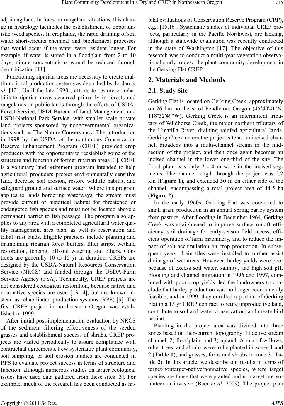 Plant Community Development in a Dryland CREP in Northeastern Oregon745 adjoining land. In forest or rangeland situations, this chan- ge in hydrology facilitates the establishment of opportun- istic weed species. In croplands, the rapid draining of soil water short-circuits chemical and biochemical processes that would occur if the water were resident longer. For example; if water is stored in a floodplain from 2 to 10 days, nitrate concentrations would be reduced through denitrification [11]. Functioning riparian areas are necessary to create mul- tifunctional production systems as described by Jordan et al. [12]. Until the late 1990s, efforts to restore or reha- bilitate riparian areas occurred primarily in forests and rangelands on public lands through the efforts of USDA- Forest Service, USDI-Bureau of Land Management, and USDI-National Park Service, with smaller scale private land projects sponsored by nongovernmental organiza- tions such as The Nature Conservancy. The introduction in 1998 by the USDA of the continuous Conservation Reserve Enhancement Program (CREP) provided crop producers with the opportunity to reestablish some of the structure and function of former riparian areas [3]. CREP is a voluntary land retirement program intended to help agricultural producers protect environmentally sensitive land, decrease soil erosion, restore wildlife habitat, and safeguard ground and surface water. Where this program applies to lands bordering waterways, the stream must provide current or historical habitat for threatened or endangered fish species and must not be located above a permanent barrier to fish passage. The program also ap- plies to any area with a completed agricultural water qua- lity management area plan, as well as reservation and tribal trust lands. Eligible practices include planting and maintaining riparian forest buffers, filter strips, wetland restoration, fencing, off-site watering and others. Con- tracts are generally 10 to 15 yr in duration. CREPs are designed by the USDA-Natural Resources Conservation Service (NRCS) and funded through the USDA-Farm Service Agency (FSA). Technically, CREP projects are not considered ecological restoration, because native and non-native species are used [13,14], but are known in- stead as rehabilitated production systems (RPS) [3]. The first CREP project in northeastern Oregon was estab- lished in 1999. After initial post-implementation evaluation by NRCS of the sediment filtering effectiveness of the seeded grasses and establishment success of shrubs, CREP pro- jects are visited periodically to assure compliance with contractual agreements. Few systematic plant community, soil sampling, or soil erosion studies are conducted in RPS to evaluate project success in terms of structure and function, although numerous studies on larger ecological issues have used data gathered from these sites [3]. For example, much of the research has been conducted as ha- bitat evaluations of Conservation Reserve Program (CRP), e.g., [15,16]. Systematic studies of individual CREP pro- jects, particularly in the Pacific Northwest, are lacking, although a statewide evaluation was recently conducted in the state of Washington [17]. The objective of this research was to conduct a multi-year vegetation observa- tional study to describe plant community development in the Gerking Flat CREP. 2. Materials and Methods 2.1. Study Site Gerking Flat is located on Gerking Creek, approximately on 26 km northeast of Pendleton, Oregon (45˚49'41"N, 118˚32'49"W). Gerking Creek is an intermittent tribu- tary of Wildhorse Creek, the major northern tributary of the Umatilla River, draining rainfed agricultural lands. Gerking Creek enters the project site as an incised chan- nel, broadens into a multi-channel stream in the mid- section of the project, and then once again becomes an incised channel in the lower one-third of the site. The flood plain was only 2 - 4 m wide in the incised seg- ments. The channel length through the project was 2.2 km (Figure 1), and extended 50 m on either side of the channel, encompassing a total project area of 44.5 ha (Figure 2). In the early 1960s, Gerking Flat was converted to small grain production in an annual spring barley system from pasture. After flooding in December 1964, Gerking Creek was straightened to improve surface runoff effi- ciency, soil drainage for early-season field access, effi- cient operation of farm machinery, and to reduce the im- pact of salt accumulation on crop production. In subse- quent years, drain tiles were installed to further assist drainage of wet areas. However, barley yields were poor because of excess soil water, salinity, and high soil pH. Flooding and channel migration in 1996 and 1997, com- bined with poor crop yields, led the landowners to con- clude that barley production was no longer economically feasible, and in 1999, they enrolled a portion of Gerking Flat in a 15 yr CREP contract to retire unproductive land, contribute to soil and water conservation, and create bird habitat. Planting in the project area was divided into three zones based on then-current topography: 1) active stream channel, 2) floodplain, and 3) upland. A mix of willows, other trees, and shrubs were to be planted in zones 1 and 2 (Table 1), and grasses, forbs and shrubs in zone 3 (Ta- ble 2). In this article, we describe our results in terms of target/nontarget-native/nonnative species, where target species are those that were planted and nontarget are vo- lunteer or invasive (Baer et al. 2009). The project plan Copyright © 2011 SciRes. AJPS  Plant Community Development in a Dryland CREP in Northeastern Oregon 746 Figure 1. Location of Gerking Creek within Oregon. Figure 2. Aerial photograph taken in 2008 of Gerking Flat CREP, channels, and vegetation transects. called for a density of 500 live trees per hectare. Based on NRCS and Pheasants Forever planting lists, a total of 200 cottonwoods, 500 willows, and 875 shrubs of vari- ous species were planted (Table 1). Trees and shrubs were planted from 0.9 to 4.3 m or an average of 2.6 m on each side of the channel in April, 2000, and January, 2002. Shrubs and trees were hand watered once after planting. Table 1. Tree and shrub species planted in 1999 in the Gerk- ing Flat CREP (source: USDA- Natural Resources C onserva- tion Service and Pheasants Forever). Species No. Planted Black cottonwood (Populus trichocarpa) 200 Willow (Salix exi q ua , Sa li x spp.) 500 Woods rose (Rosa woods ii) 75 Nootka rose (Rosa nutka na) 75 Snowberry (Symphor ic arpos al bus ) 100 American plum (Pr un us am erican a) 75 Chokecherry (Prunus virginiana) 100 Elderberry (Sambucus race mo sa) 50 Golden current (Ribes aureum) 50 Buckbrush (Ceanothus cuneatus) 50 Western white clematis (C lematis ligustici folia.) 25 Table 2. Target grass and forb species planted in 1999 in the Gerking Flat CREP. Species Percent of mix Nonnative Meadow foxtail (Alopecurus pratensis) 13 Alfalfa (M edicago sa tiva ) 10 Yellow sweetclover (Melilotus of ficin al is ) 8 Tall fescue (Festuca ar u ndin acea) 22 Tall wheatgrass (Thinopyrum ponticum) 11 Native species Basin wildrye (Elymus cinerus) 6 Streambank wheatgrass (Elymus lanceolatus) 4 Western wheatgrass (Agropyron sm ithii) 5 Alkali sacaton (Sporobol us a ir o ides) 21 Prior to seeding, weeds were controlled with herbicides and disking. The grass/forb mix was seeded in the spring of 1999 at 22.4 kg/ha, with a seed weight ratio of 36:100 native to nonnative species. Post-seeding weed control was conducted on the entire site by mowing in the spring of 2000 and 2001. In 2002, the eastern, upstream quarter of the site was disked lightly to control weeds and elimi- nate the heavy mat of dead vegetation that had developed. The landowner, in consultation with NRCS personnel, concluded that burning some portion of the site annually would not damage the established grasses, and would result in less open ground for nontarget species invasion. Subsequently, spring burns were conducted before bird nesting season on approximately one-quarter of the site each year from 2002 to 2005. Exact records of burn dates and specific areas burned were not kept. Alleyways were also randomly cut through the site each year to provide Copyright © 2011 SciRes. AJPS  Plant Community Development in a Dryland CREP in Northeastern Oregon747 upland game bird hunting access. Meteorological records dating from 1931 at the USDA Columbia Plateau Conservation Research Center and Ore- gon State University Columbia Basin Agricultural Re- search Center, 14 km south of the research site, show minimum and maximum air temperatures of −34˚C and 46˚C, with a 71 yr average mean annual temperature of 11˚C. Annual frost-free days range from 135 to 170 [18]. Approximately 70% of precipitation occurs between No- vember and April, with annual precipitation averaging 422 mm. Snow cover is transient, with accumulated snow subject to rapid melting by frequent marine warm fronts from the Pacific Ocean. Soils are Hermiston silt loams (coarse-silty, mixed, mesic Cumulic Haploxeroll) and Pedigo silt loam (coarse-silty, mixed, superactive, mesic Cumulic Haploxerolls), formed in silty alluvium from loess and ash on flood plains and low terraces. These soils overlay the fractured Miocene basalt layers of the Columbia Plateau, and slopes range from 0 to 3% [18]. 2.2. Monitoring and Sampling Procedures We established permanent line-point transects [19] ex- tending 50 m perpendicularly east and west from the ac- tive channel edge to quantify plant cover by species (Fig- ure 2). Transects were established at regular intervals of 100 m throughout the project area using survey grade GPS equipment. Each 50 m transect was stratified by distance from the channel edge in 5 m increments, and five points were randomly sampled within each of these increments. Cover, by species, litter, or bare ground was recorded at each point. Plant species were referred to as target-native, target-nonnative, nontarget-native, and non- target-nonnative, where target species were those that had been planted under the CREP program [3]. We sampled in May and June in 2000, 2001, and 2008, and in July and August in 2007. Individual trees and shrubs in the project area were counted in August, 2008; willow spe- cies were identified separately from this census. 2.3. Experimental Design and Statistical Procedures The study reported here is descriptive. Data were gra- phically and statistically analyzed to determine if there were differences in species composition and vegetation cover among years. We calculated Simpson’s diversity index (N2), 2 NN 11, ii nn (1) where n is the total number of organisms of a particular species and N is the total number of organisms of all species, and the Simpson equitability index (E), 2 ENS, (2) where S = the total number of species identified at time of sampling. These values were calculated, by year, for the entire site [20]. Analysis of cover and species com- position was conducted using a mixed-model, repeated measures ANOVA GLIMMIX procedure to model the response using a binomial distribution, and least square means separation tests where significant main effects and interaction terms were found [21]. 3. Results and Discussion 3.1. Research Site Conditions Weather conditions were warmer and drier than normal from 2001 through 2008, relative to the previous 70 yr. Mean annual temperatures were higher than normal in all years except 2004 and 2005 and total annual precipita- tion was below the long-term average in 2001, 2002, 2003, 2005, and 2008. Construction of a building and pasture establishment between 2001 and 2007 eliminated parts of two transects (16 & 17). We were, however, able to conduct a census of trees and shrubs planted within 10 m of the channel in these areas. 3.2. Ground Cover Total ground cover was nearly 100% during all years of sampling, with means and standard errors of 99.8% ± 0.1%, 99.9% ± 0.1%, 97.1% ± 0.5%, and 97.3% ± 0.8% for 2000, 2001, 2007, and 2008. However, bare soil in- creased significantly from 0% in 2001 to 1.7% ± 0.5% in 2007 (P ≤ 0.05) (Figure 3), and there was a significant increase in detritus (dead and down material) from 2001 to 2007 (Figure 4). The increase in bare soil and detritus and decrease in living plant material from 98% in 2000- 2001 to 33% in 2007 and return to 68% in 2008 corre- sponded with a reduction in tall wheatgrass and increase in other nontarget species (Figure 5). After the tall wheat- grass matured, largely as a monoculture in the first two years, it began to die. In 2007 we found large areas of standing dead tall wheatgrass 2 m in height, without any other vegetation in the understory, where annual nonna- tive species established in 2008. The total contribution by native species to plant cover was <10% during any year (Figure 6). Six nontarget- native species contributed 3% and 16 nontarget-nonna- tive species contributed 16% of the plant cover by 2008 (Table 3). 3.3. Plant Species Diversity and Community Development We identified 32 individual species of grasses and forbs in the permanent transects over the course of the study, of which 23 were nontarget species (Table 3). Not all Copyright © 2011 SciRes. AJPS  Plant Community Development in a Dryland CREP in Northeastern Oregon Copyright © 2011 SciRes. AJPS 748 Figure 3. Changes in bare soil demonstrating increased plant community complexity from 2000 through 2008. Figure 4. Ground cover contribution by detritus from 2000 through 2008. Figure 5. Composition by individual species at Gerking Flat from 2000 through 2008. species were present every year, with 15 in 2000, 18 in 2001, 18 in 2007, and 21 in 2008. Across the site N2 was 1.6 in 2000 and 1.5 in 2001, increasing to 5.3 in 2007 with a shift down to 4.4 in 2008. This change in N2 indi- cates an increase in species diversity. However, an in- crease in diversity alone is not sufficient grounds to judge a rehabilitation project a success. We will discuss this concept further in this article. No shrubs or trees were found in any of the line transects during any sample year. Despite a substantial die-off, tall wheatgrass remained the dominant species in 2008 (Figure 5). The other tar- geted species, native and introduced, contributed ≤10% to total cover and only basin wildrye contributed >1% cover in 2008. Of the remaining four target-nonnative species, none contributed more than 2% cover during any  Plant Community Development in a Dryland CREP in Northeastern Oregon749 Figure 6. Nati ve species contri bution to pla nt co ver. Table 3. Nontarget species identified in Gerking Flat CREP. Species Nonnative Wild oat (Avena fatua) Kocia, Mexican fireweed, mock cypress, Mirabel (Kochia scoparia Ripgut brome (Bromus diandrus) Downey brome (Bromus tectorum) Canada thistle (Cirs i um arve nse) Hairy fleabane, wavy-leaf fleabane, flax-leaf fleabane, asthmaweed (Conyza bonariensis) Prickly lettuce (Lactuca serriola) Oxeye daisy (Chrysanthemum leucanthemum) Catnip (Nepeta cataria) Scotch thistle, Scotch cottonthistle (Onopordum acanthium) Rabbitfoot polypogon, annual rabbitsfoot grass (Poly pogon mo nspeliensis) Tumble mustard (Sisym brium altissimum) Pineapple weed, disc mayweed (Matriciaca ri a matric arioides) Lambsquarters (Chenopodium album) Fiddleneck Tarweed (Amsinckia lycopsoid es) Cutleaf Nightshade (Solanum triflorum) Black Mustard (Brassica nigra) Native Willowweed; dwarf fireweed (Epilobium latifolium ) [Canadian] Horseweed (Conyza canadensis) False quackgrass (Elymus × pseudorepens) Field horsetail (Equisetum arvense) Hardstem bulrush (Sch oenop lectus acutus var. acutus) Common cattail, broadleaf cattail (Typha latifolia L.) American speedwell (Veronica americana) year of sampling and none were present in 2008. Only two of the four target-native species, basin wildrye and alkali sacaton remained present in 2008, contributing 5% and 2% cover, respectively. Of the nontarget species identified, 16 were nonnative and 7 were native. Four of the nontarget native species were early colonizers of moist, primary successional sites (field horsetail, hardstem bulrush, common cattail, and American speedwell). Although considered weed species in croplands, all might be expected to contribute to native riparian habitat. Two nontarget natives, Cana- dian horseweed, and dwarf fireweed or willowweed, were found sparsely distributed throughout the site. False quackgrass, a nontarget native found in 2001, was not found in 2007 or 2008. The progressive shift from tar- get-nonnative toward nontarget-nonnative dominance at the site from 2000 to 2008 resulted from increases in wild oats, kochia, Canada thistle, and tumble mustard. Low species diversity and evenness values (on Gerk- ing Flat N = 32, N2 ≤ 5.3, and corresponding E ≤ 0.29) are commonly found in rehabilitated agricultural systems [3]. Generally, these values are reported with a reference value from local native remnant plant communities as a measure of project success. For our purposes, and be- cause we lack a native comparison site, we rely on the general definition of the indices to conclude that the Gerking Flat RPS has low species diversity and evenness. The relevance of these values to the functioning of plant communities is the center of an ongoing debate [22], although it is important from a managerial perspective to understand that fully functioning ecosystems generally score higher in both indices. 3.4. Shi ft f r om Targ et t o No nt ar get Spe ci es Target-nonnative species comprised significantly more of the vegetation composition than all other classes (P ≤ 0.05), during 2000 and 2001, but nontarget species in- creased substantially in 2007 and 2008 (Figure 7). This increase was predominately by Eurasian annuals typi- cally found in disturbed semiarid and arid landscapes (Figure 5). Nontarget-native species can alter the in- tended development trajectory of an RPS [3]. These spe- cies are exceptionally well adapted for invading dis- turbed areas where soil conditions and lack of seed sources reduce competition from native plants. Once est- ablished, these communities of invasive species tend to persist unless there is substantial management interven- tion [3]. Management options in CREP are limited to light soil surface disturbance (disking), mowing, burning, and limited herbicide use. The producer managing Gerk- ing Flat mowed the site after the first year to control seed production from nonnative annuals. An attempt at disk- ing part of the site was judged counterproductive, and the Copyright © 2011 SciRes. AJPS  Plant Community Development in a Dryland CREP in Northeastern Oregon 750 Figure 7. Vegetation composition by target-nontarget native- nonnative species. producer opted for burning some portion of the site each spring thereafter. Burning eliminated accumulating dead material, but apparently had no effect on slowing the increase in nontarget-nonnative species. In Mississippi, Greenfield et al. [16] were able to improve bobwhite habitat by disking or burning a 10 yr old CRP field, but the improvement was short-lived and plant community composition was unaffected. Disking, mowing, and burn- ing are effective if applied at the appropriate plant phe- nological stage, i.e. before seed set. But such timing is likely to interfere with critical wildlife use, such as nest- ing. Grazing has been proposed as a means of upland weed suppression (e.g. [23]), and can contribute to nu- trient cycling advantageous to target species [3]. How- ever, grazing is restricted in most CREP contracts, and many of the CREP projects on the Columbia Plateau are managed by single commodity producers without the animal or managerial resources needed for grazing. 3.5. Tree and Shrub Development Establishment of willows can be considered successful. Of the 500 willows originally planted, we were able to identify 279 individual plants in 2008. These were lo- cated in the lower half of the project where most of the tree and shrub planting took place (Mr. Bud Schmidtgall, landowner, personal communication). The survival of other trees and shrubs appears to have been low, and com- pletely unsuccessful with respect to cottonwood, Nookai rose, American plum, choke cherry, elderberry, golden current, buckbrush, and western clematis. We recorded one nontarget-native species, red osier dogwood. Com- plete results of the tree and shrub census appear in Table 4. 3.6. Projec t Eva luat ion The project on Gerking Flat met the basic objective of Table 4. Trees and shr ubs f ound in z ones 1 a nd 2 (descri be d in text) in a September, 2008, census. Species Number Willows (Salix spp.) 279 Pacific willow (Salix lucida ssp. lasiandra) Scouler willow (Salix scouleriana) Coyote willow (Salix exigua) Dusky willow (Salix melanopsis) Booth’s willow (Salix boothii) Woods rose (Rosa woods ii) 15 Snowberry (Symphor ic arpos al bus ) 15 Red osier dogwood (Cornus sericea) 5 Black cottonwood (Populus trichocarpa) 4 providing ground cover, >90% in 2008, to conserve soil. A continuous canopy of willows now covers the channel in the lower one-third of the project. Increased root and stem biomass slows erosion, both within and outside the stream channels, and traps soil eroded from surrounding fields and borrow ditches [2,24-26]. An early concern with the planting of trees and shrubs in channels was they would be too effective and cause the channel to mi- grate, especially in areas where the original channel was some distance, and lower, than the constructed channel. Although more sinuosity in a channelized stream might ultimately be a desirable objective, in the early phases of the project channel movement could have jeopardized establishment of newly planted vegetation. Anecdotally, there seemed to be substantially more raptors and upland game birds at the site than in sur- rounding fields or adjacent to Gerking Creek above and below the project. This was expected, as avian communi- ties increase with increasing plant community complex- ity, including variety in plant size and life form, and ac- cumulation of detritus [15]. Before the project was begun, the site was a mono-cropped agricultural field, and in 2000 and 2001 the site supported a monoculture of the targeted-nonnative tall wheatgrass. By 2008, we observed patchiness in the distribution of vegetation, with distinct areas of tall wheatgrass, nontarget-nonnative species (pri- marily annual or biannual forbs), and accumulations of detritus in various states of decomposition throughout the site. 4. Conclusions The Gerking Flat CREP project planted in 1999 has ful- filled the primary objectives of establishing a plant com- munity with sufficient cover to trap sediment from off- site, reduce erosion onsite, and provide cover and habitat for upland game birds. In the first 2 yr after planting, 2000 and 2001, the stand was dominated by a target- Copyright © 2011 SciRes. AJPS  Plant Community Development in a Dryland CREP in Northeastern Oregon751 nonnative species, tall wheatgrass, with low overall di- versity and evenness. After 6 and 7 yr, diversity values and evenness values both increased incrementally. Com- plexity of the site increased with an increase of detritus in various stages of decomposition, and patchiness with- in the community that was observed, but not captured by the sampling regime. Nontarget-nonnative species in- creased most at the site, which suggests that the current spring burning regime will have to be supplemented by other weed control measures to prevent conversion of the site to an annual nonnative plant community. Possible alternatives include well-timed applications of herbicide or intensive grazing management, and are decisions that must be taken in the context of landowner willingness to keep the land enrolled in this program. Although the immediate objectives of this project were met, establish- ment and development of plant communities dominated by nontarget-nonnative species create a seed source for infestation of surrounding crop land, potentially creating an economic drain on producers and ill will toward such projects. CREP projects are finite and depend on the competitiveness of program payments with alternate land uses and landowner satisfaction with project develop- ment and outcome. Arguably, participants will be chal- lenged by economic pressures to return these sites to production [27], even with successful establishment of healthy stands of targeted species. However, emerging resource concerns, such as downstream water quality issues and ecosystem service markets, including the car- bon sequestration potential of restored CREP sites, may help counter such pressures. A more extensive evaluation of plant communities, hydrologic response, and other resource values in CREP projects should be undertaken, and lessons learned throughout the Pacific Northwest compiled to aide in future rehabilitation efforts. 5. Acknowledgments We wish to thank Bud Schmidtgall, Athena, Oregon for his cooperation in allowing us to conduct the sampling and publish a manuscript based on that information. Dave Robertson, Daryl Haasch, Felicity Dye, and Stefka Waite aided in collecting and summarizing the data. In addition to participation in this project by USDA-NRCS and -FSA, resources were contributed by the Umatilla Soil and Water Conservation District, Confederated Tribes of the Umatilla Reservation, Oregon Department of Forestry, Potlach Corporation, and Pheasants Forever. REFERENCES [1] R. T. T. Forman, “Land Mosaics: The Ecology of Land- scapes and Regions,” Cambridge University Press, Cam- bridge/New York, 1995. [2] R. A. Pearce, M. J. Trlica, W. C. Leininger, D. E. Mergen and G. W. Frasier, “Sediment Movement through Ripar- ian Vegetation under Simulated Rainfall and Overland Flow,” Journal of Range Management, Vol. 51, No. 3, 1998, pp. 301-308. doi:10.2307/4003415 [3] S. G. Baer, D. M. Engle, J. M. H. Knops, K. A. Lange- land, B. D. Maxwell, F. D. Menalled and A. J. Symstad, “Vulnerability of Rehabilitated Agricultural Production Systems to Invasion by Nontarget Plant Species,” Envi- ronmental Management, Vol. 43, No. 2, 2008, pp. 189- 196. doi:10. 10 07/ s00 267 -0 08- 91 67- 6 [4] S. J. Bennett, T. Pirim and B. D. Barkdoll, “Using Simu- lated Emergent Vegetation to Alter Stream Flow Direc- tion within a Straight Experimental Channel,” Geomor- phology, Vol. 44, No. 1-2, 2002, pp. 115-126. doi:10.1016/S0169-555X(01)00148-9 [5] D. Corenblit, E. Tabacchi, J. Steiger and A. M. Gurnell, “Reciprocal Interactions and Adjustments between Flu- vial Landforms and Vegetation Dynamics in River Cor- ridors: A Review of Complementary Approaches,” Earth- Science Reviews, Vol. 84, No. 1-2, 2007, pp. 56-86. doi:10.1016/j.earscirev.2007.05.004 [6] J. B. Kauffman and W. C. Krueger, “Livestock Impacts on Riparian Ecosystems and Streamside Management Im- plications: A Review,” Journal of Range Management, Vol. 37, No. 5, 1984, pp. 430-438. doi:10.2307/3899631 [7] F. L. Knopf, R. R. Johnson, T. Rich, F. B. Samson and R. C. Szaro, “Conservation of Riparian Ecosystems in the United States,” Wilson Bulletin, Vol. 100, No. 2, 1988, pp. 272-284. [8] S. V. Gregory, F. J. Swanson, W. A. McKee and K. W. Cummins, “An Ecosystem Perspective of Riparian Zones,” BioScience, Vol. 41, No. 8, 1991, pp. 540-551. doi:10.2307/1311607 [9] A. C. McGregor, “Counting Sheep: From Open Range to Agribusiness on the Columbia Plateau,” University of Washington Press, Seattle, Washington, 1982. [10] A. Simon and A. J. C. Collison, “Pore-Water Pressure Effects on the Detachment of Cohesive Streambeds: Seepage Forces and Matric Suction,” Earth Surface Process e s and Landfor m s , Vol. 26, No. 13, 2001, pp. 1421- 1442. doi:10.1002/esp.287 [11] D. W. Rassam, C. S. Fellows, R. D. Hayr, H. Hunter and P. Bloesch, “The Hydrology of Riparian Buffer Zones; Two Case Studies in an Ephemeral and a Perennial Stream,” Journal of Hydrology, Vol. 325, No. 1-4, 2006, pp. 308-324. doi:10.1016/j.jhydrol.2005.10.023 [12] N. Jordan, G. Boody, W. Broussard, J. D. Glover, D. Keeney, B. H. McCown, G. McIsaac, M. Muller, H. Murray, J. Neal, C. Pansing, R. E. Turner, K. Warner and D. Wyse, “Environment: Sustainable Development of the Agricultural Bio-Economy,” Science, Vol. 316, No. 5831, 2007, pp. 1570-1571. doi:10.1126/science.1141700 [13] A. D. Bradshaw, “Underlying Principles of Restoration,” Canadian Journal of Aquatic Science, Vol. 53, Supple- ment 1, 1996, pp. 3-9. [14] J. B. Kauffman, R. L. Beschta, N. Otting and D. Lytjen, “An Ecological Perspective of Riparian and Stream Res- Copyright © 2011 SciRes. AJPS  Plant Community Development in a Dryland CREP in Northeastern Oregon Copyright © 2011 SciRes. AJPS 752 toration in the Western United States,” US Fisheries, Vol. 22, No. 5, 1997, pp. 12-24. doi:10.1577/1548-8446(1997)022<0012:AEPORA>2.0.C O;2 [15] K. F. Millenbah, S. R. Winterstein, H. Campa III, L. T. Furrow and R. B. Minnis, “Effects of Conservation Re- serve Program Field Age on Avian Relative Abundance, Diversity, and Productivity,” Wilson Bulletin, Vol. 108, No. 4, 1996, pp. 760-770. [16] K. C. Greenfield, M. J. Chamberlain, J. Bruger, L. Wes and E. W. Kurzejeski, “Effects of Burning and Discing Conservation Reserve Program Fields to Improve Habitat Quality for Northern Bobwhite (Colinus Virginianus),” American Midland Naturalist, Vol. 149, No. 2, 2003, pp. 344-353. doi:10.1674/0003-0031(2003)149[0344:EOBADC]2.0.C O;2 [17] C. J. Smith, “Evaluation of CREP Riparian Buffers in Washington State. Prepared for Washington State Con- servation Commission,” Washington State Conservation Commis s i on Board Membe r s , Washington, 2006, p. 61. [18] D. R. Johnson and A. J. Makinson, “Soil Survey of Uma- tilla County area, Oregon,” USDA—Soil Conservation Ser- vice, US Government Printing Office, Washington DC, 1988. [19] C. D. Bonham, “Measurements for Terrestrial Vegeta- tion,” John Wiley & Sons, New York, 1989. [20] R. H. Green, “Sampling Design and Statistical Methods for Environmental Biologists,” John Wiley & Sons, New York, 1979. [21] SAS, SAS/STAT 9.2 User’s Guide. SAS Institute Inc., Cary, NC, 2008. [22] A. R. Ives and S. R. Carpenter, “Stability and Diversity of Ecosystems,” Science, Vol. 317, No. 5834, 2007, pp. 58- 62. doi:10.1126/science.1133258 [23] J. McIver and L. Starr, “Restoration of Degraded Lands in the Interior Columbia River Basin: Passive vs. Active Approaches,” Forest Ecology and Management, Vol. 153, No. 1-3, 2001, pp. 15-28. doi:10.1016/S0378-1127(01)00451-0 [24] R. D. Harmel, C. T. Haan and R. Dutnell, “Bank Erosion and Riparian Vegetation Influences: Upper Illinoies River, Oklahoma,” Transactions of the American Society of Ag- ricultural Engineers , Vol. 42, No. 5, 1999, pp. 1321-1330. [25] K. Gran and C. Paola, “Riparian Vegetation Controls on Braided Stream Dynamics,” Water Resource Research, Vol. 37, No. 12, 2001, pp. 3275-3283. doi:10.1029/2000WR000203 [26] Z. O. Toledo and J. B. Kauffman, “Root Biomass in Re- lation to Channel Morphology of Headwater Streams,” Journal of the American Water Resources Association, Vol. 37, No. 6, 2001, pp. 1653-1663. doi:10.1111/j.1752-1688.2001.tb03667.x [27] T. L. Napier, “Grain Scarcity: A New Era for Conserva- tion Policies and Programs,” Journal of Soil and Water Conservat i on, Vol. 64, No. 1, 2009, pp. 7A-10A. doi:10.2489/jswc.64.1.7A
|