S. MOGREN, M. MUKHOPADHYAY
32
Sea extension. e). The crustal configuration derived from
gravity modeling for the entire traverse supports the
consensus view on Red Sea spreading for the region.
However, further detailing of gravity model is inhibited
by the present coverage of gravity stations, in particular,
for the boundary crust and the deformed belt.
3. Conclusions
An integrated interpretation of surface geologic, seismic
deep refraction and regional gravity data allow us to
draw the following broad conclusions on the boundary
crust developed due to Red Sea spreading in mid-Terti-
ary at the Arabian Shield margin. Signatures of rifting
and crustal thinning are dominant here. Some basic con-
clusions of the study are:
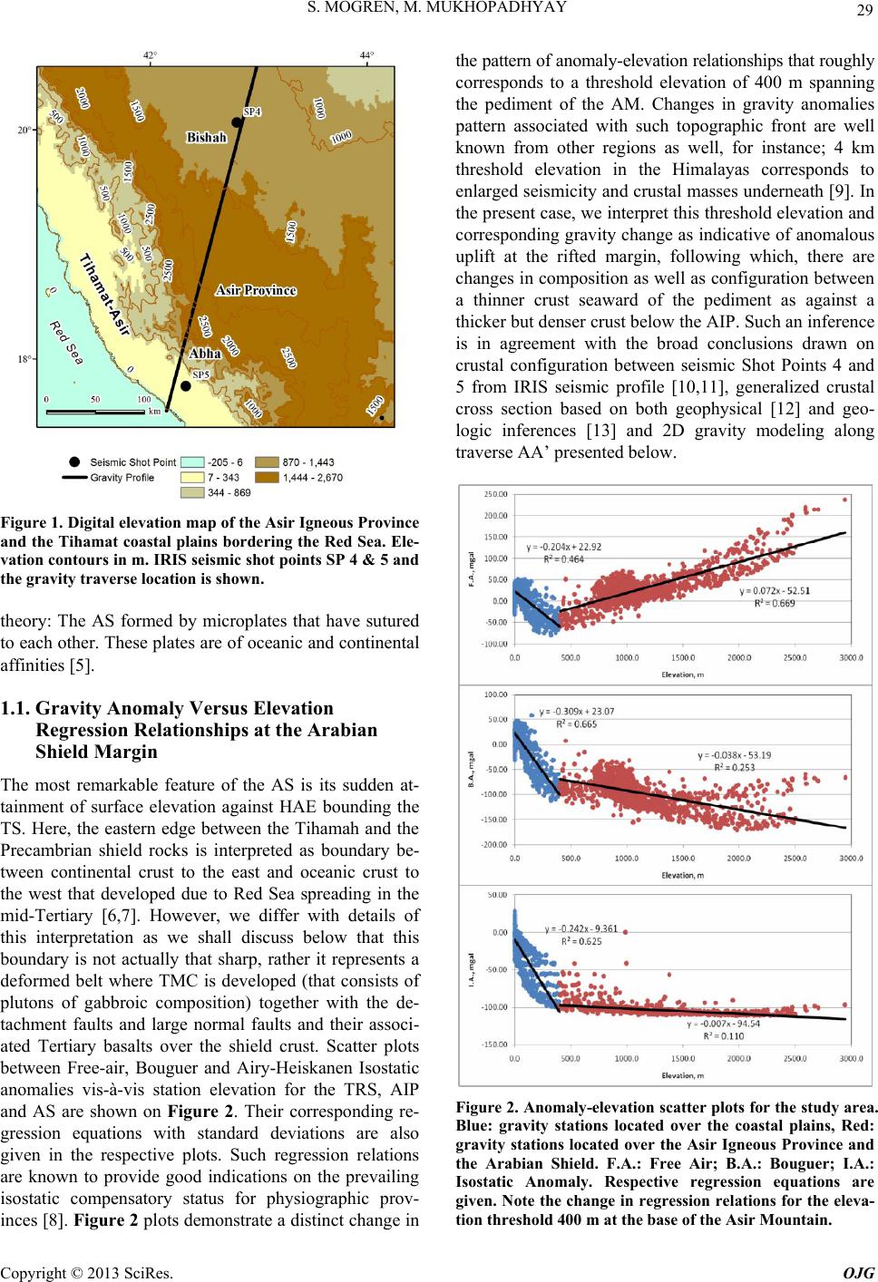
a) Predominantly mafic crust below the Thimaya
coastal plains transits into a thicker continental crust be-
low the Asir province across a rather wide transition zone
and deformed belt. The former consists of a deep- pene-
trative mafic crustal column of interpreted width of 115
km, beside a wider zone of detachment faults and basalts
atop the Asir crust. The Tertiary mafic crustal column is
denser than the shield crust by at least 0.1 g/cm3, it has
vertical side to the south but an inclined contact with the
Asir crust. The dipping Moho under the transitional crust
is quite characteristic. Western edge of the TMC is dis-
tinguished by a clear change in gravity signature corre-
sponding to a threshold elevation of about 450 m across
the pediment of the Asir, while, its eastern flank on the
top surface is intimately involved with the basalts and
detachment fault - typically representing an extensional
margin [22].
b) Zone of deformation in the continental rocks of the
Asir is much wider. Gravity modeling suggests that the
upper crust is denser by about 0.07 g/cm3 as compared to
the top basement further east. Surface geologic features
in top crust of AP like: the Basalt detachment Fault, ba-
salts, large normal faults in the deformed belt are consid-
ered quite diagnostic of a stretched crust at the shield
margin. Interface between the crust and mid-crust proba-
bly represents a low angle fault in the deformed belt that
has been inferred geologically. Local gravity ‘low’ and
‘high’ in the deformed belt are interpreted in gravity
modeling as to represent felsic and mafic plutons respec-
tively, invading the top crust in the Asir. Geometry of
such initial intrusions (plutons and dikes) inferred from
gravity modeling need further geophysical investigations
owing to their intimate relationship to Red Sea extension.
REFERENCES
[1] D. B. Stoeser and C. D. Frost, “Nd, Pb, Sr, and O Isotopic
Characterization of Saudi Arabian Shield Terranes,”
Chemical Geology, Vol. 226, 2006, pp. 163-188.
doi:10.1016/j.chemgeo.2005.09.019
[2] V. E. Camp, “Island Arcs and Their Role in the Evolution
of the Western Arabian Shield,” The Geological Society
of Amrica, Bull, Vol. 95, 1984, pp. 913-921.
doi:10.1130/0016-7606(1984)95<913:IAATRI>2.0.CO;2
[3] V. E. Camp and M. J. Roobol, “Upwelling Asthenosphere
Beneath Western Arabia and Its Regional Implications,”
Journal of Geophysical Research, Vol. 97, No. B11, 1992,
pp. 15255-15271. doi:10.1029/92JB00943
[4] J. Kemp, C. Pellaton and J. Y. Calvez, “Cycles in the
Chelogenic Evolution of the Precambrian Shield in Part
of Northwestern Saudi Arabia,” Dir. General Mineral
Resour. Prof. Paper PP-I, 1982, pp. 27-41. Saudi Arabia
Deputy Minist. Miner. Resour., Jiddah.
[5] D. B. Stoeser and V. E. Camp, “Pan-African Microplate
Accretion of the Arabian Shield,” The Geological Society
of America, Vol. 96, No. 7, 1985, pp. 817-826.
doi:10.1130/0016-7606(1985)96<817:PMAOTA>2.0.CO
;2
[6] R. J. Stern and P. Johnson, “Continental Lithosphere of
the Arabian Plate: A Geologic, Petrologic and Geophysi-
cal Synthesis,” Earth-Science Review, Vol. 101, No. 1-2,
2010, pp. 29-67.doi:10.1016/j.earscirev.2010.01.002
[7] M. E. Gettings, “Delineation of the Continental Margin in
the Southern Red Sea Region from New Gravity Evi-
dence,” In: Red Sea Research 1970-1975, Bull. No. 22,
Ministry Pet. Mineral Resource, DGMR-Jiddah, Saudi
Arabia, pp. K1-K11.
[8] M. Kono, “Gravity Anomalies in East Nepal and Their
Implications to the Crustal Structure of the Himalaya,”
Geophysical Journal International, Vol. 39, No. 2, 1974,
pp. 283-299. doi:10.1111/j.1365-246X.1974.tb05455.x
[9] L. Seeber and J. C. Ambruster, “Great Detachment Earth-
quakes Along the Himalayan Arc and Long-term Fore-
casting,” Maurice Ewing Series, Vol. 4, 1981, pp.
259-277. doi:10.1029/ME004p0259
[10] J. H. Healy, W. D. Mooney, H. R. Blank, M. E. Gettings,
W. M. Kohler, R. J. Lamson and L. E. Leone, “Saudi
Arabian Seismic Deep-Refraction Profile: Final Project
Report,” Open-File Report USGS-OF-02-37, 1982, p. 429.
including appendices, Saudi Arabia Deputy Minist. Miner.
Resour, Jiddah.
[11] W. D. Mooney, M. E. Gettings, H. R. Blank and J. H.
Healy, “Saudi Arabian Seismic Deep-Refraction Profile:
A Traveltime Interpretation of Crustal and Upper Mantle
Structure,” Tectonophys, Vol. 111, 1985, pp. 173-246.
doi:10.1016/0040-1951(85)90287-2
[12] M. E. Gettings, H. R. Jr. Blank, W. D. Mooney and J. H.
Healey, “Crustal Structure of Southwestern Saudi Ara-
bia,” Journal of Geophysical Research Solid Earth, Vol.
91, No. B6, 1986, pp. 6491-6512.
doi:10.1029/JB091iB06p06491
[13] R. G. Bohannon, “Tectonic Configuration of the Western
Arabian Continental Margin, Southern Red Sea,” Tecton-
ics, Vol. 5, No. 4, 1986, pp. 477-499.
doi:10.1029/TC005i004p00477
[14] J. E. Nafe and C. L. Drake, “Physical Properties of Ma-
rine Sediments,” In: M. N. Hill (editor), The Sea, Wiley,
Copyright © 2013 SciRes. OJG