62 Journal of Global Positioning Systems
laser tracking data from some tens of satellites at different
altitudes and orbit inclinations [Biancale et al., 2000].
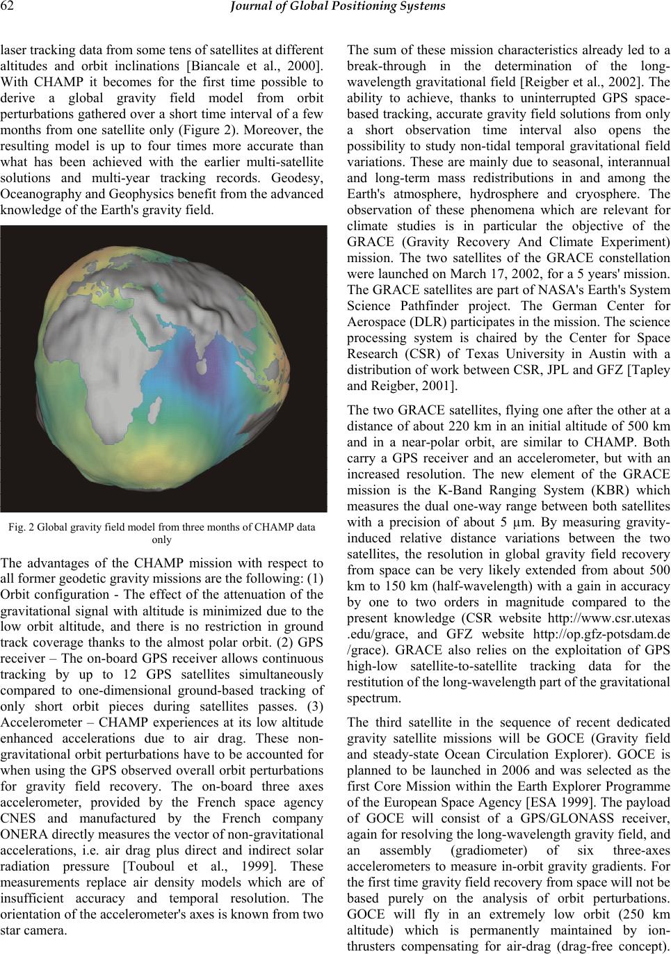
With CHAMP it becomes for the first time possible to
derive a global gravity field model from orbit
perturbations gathered over a short time interval of a few
months from one satellite only (Figure 2). Moreover, the
resulting model is up to four times more accurate than
what has been achieved with the earlier multi-satellite
solutions and multi-year tracking records. Geodesy,
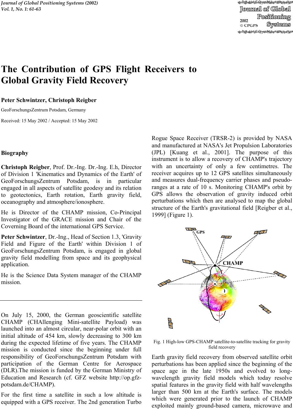
Oceanography and Geophysics benefit from the advanced
knowledge of the Earth's gravity field.
The sum of these mission characteristics already led to a
break-through in the determination of the long-
wavelength gravitational field [Reigber et al., 2002]. The
ability to achieve, thanks to uninterrupted GPS space-
based tracking, accurate gravity field solutions from only
a short observation time interval also opens the
possibility to study non-tidal temporal gravitational field
variations. These are mainly due to seasonal, interannual
and long-term mass redistributions in and among the
Earth's atmosphere, hydrosphere and cryosphere. The
observation of these phenomena which are relevant for
climate studies is in particular the objective of the
GRACE (Gravity Recovery And Climate Experiment)
mission. The two satellites of the GRACE constellation
were launched on March 17, 2002, for a 5 years' mission.
The GRACE satellites are part of NASA's Earth's System
Science Pathfinder project. The German Center for
Aerospace (DLR) participates in the mission. The science
processing system is chaired by the Center for Space
Research (CSR) of Texas University in Austin with a
distribution of work between CSR, JPL and GFZ [Tapley
and Reigber, 2001].
The two GRACE satellites, flying one after the other at a
distance of about 220 km in an initial altitude of 500 km
and in a near-polar orbit, are similar to CHAMP. Both
carry a GPS receiver and an accelerometer, but with an
increased resolution. The new element of the GRACE
mission is the K-Band Ranging System (KBR) which
measures the dual one-way range between both satellites
with a precision of about 5 µm. By measuring gravity-
induced relative distance variations between the two
satellites, the resolution in global gravity field recovery
from space can be very likely extended from about 500
km to 150 km (half-wavelength) with a gain in accuracy
by one to two orders in magnitude compared to the
present knowledge (CSR website http://www.csr.utexas
.edu/grace, and GFZ website http://op.gfz-potsdam.de
/grace). GRACE also relies on the exploitation of GPS
high-low satellite-to-satellite tracking data for the
restitution of the long-wavelength part of the gravitational
spectrum.
Fig. 2 Global gravity field model from three months of CHAMP data
only
The advantages of the CHAMP mission with respect to
all former geodetic gravity missions are the following: (1)
Orbit configuration - The effect of the attenuation of the
gravitational signal with altitude is minimized due to the
low orbit altitude, and there is no restriction in ground
track coverage thanks to the almost polar orbit. (2) GPS
receiver – The on-board GPS receiver allows continuous
tracking by up to 12 GPS satellites simultaneously
compared to one-dimensional ground-based tracking of
only short orbit pieces during satellites passes. (3)
Accelerometer – CHAMP experiences at its low altitude
enhanced accelerations due to air drag. These non-
gravitational orbit perturbations have to be accounted for
when using the GPS observed overall orbit perturbations
for gravity field recovery. The on-board three axes
accelerometer, provided by the French space agency
CNES and manufactured by the French company
ONERA directly measures the vector of non-gravitational
accelerations, i.e. air drag plus direct and indirect solar
radiation pressure [Touboul et al., 1999]. These
measurements replace air density models which are of
insufficient accuracy and temporal resolution. The
orientation of the accelerometer's axes is known from two
star camera.
The third satellite in the sequence of recent dedicated
gravity satellite missions will be GOCE (Gravity field
and steady-state Ocean Circulation Explorer). GOCE is
planned to be launched in 2006 and was selected as the
first Core Mission within the Earth Explorer Programme
of the European Space Agency [ESA 1999]. The payload
of GOCE will consist of a GPS/GLONASS receiver,
again for resolving the long-wavelength gravity field, and
an assembly (gradiometer) of six three-axes
accelerometers to measure in-orbit gravity gradients. For
the first time gravity field recovery from space will not be
based purely on the analysis of orbit perturbations.
GOCE will fly in an extremely low orbit (250 km
altitude) which is permanently maintained by ion-
thrusters compensating for air-drag (drag-free concept).