1. Introduction
Several inferred positions of Baja California (BC) before detachment from the North America plate (NAM), locate the peninsula overlapping the space where Tres Marías Islands (TMI) are located at present [1,2], while others place it at different surrounding locations [3-5]. The Middle America Trench (MAT) extends from Central America throughout the western coast of Mexico and terminates at the Tres Marías Islands; it involves the Cocos and Rivera plates and follows a general NW trend. At around latitude 19.35˚N this trend changes to an arc that turns gently to the N terminating at the base of the Tres Marías Escarpment (TME). This has been the traditional representation of the terminus of the MAT [6,7] and all maps available depict it that way. A re-construction of plates and plate boundaries [8] from 15 to 3.5 Ma shows the Guadalupe plate at 15 Ma as a single plate from Guadalupe Island to south of the Clipperton and Tehuantepec fracture zones, enclosing the Cocos, Rivera, and a portion of the present Pacific plates. At that time the Guadalupe trench (the joint Middle America and North America trenches) was continuous, although somewhat deformed, across the mouth of the Proto-Gulf of California. At 9 Ma the Rivera plate extended down to the Orozco Fracture Zone and the Tosco-Abreojos fault replaced the abandoned trench west of BC as the limit between the Pacific and NAM plates, while the terminus of the MAT was already displaced from its location at the continuous trench and ending at the TME. In this re-construction the tip of the peninsula was located ~200 km NW of TMI. The Proto-Gulf of California was described as a broad volcano-tectonic rift zone created by an extensional mechanism that preceded the separation of Baja California from the NAM plate [1].
Another re-construction of the position of Baja California to 5.5 Ma was made [3] translating it 300 km back along the 124˚ azimuth of the major fracture zones. They found that the 1000-m isobath nearly abuts that north of the Tres Marías block, and that the escarpment that marks the edge of the continental crust fits exactly the curve of the base of the Tres Marías Escarpment, implicating the earlier proximity of these structures. Other re-constructions have used this translation of BC to the SE, which presumably closed the Gulf at around 5.5 Ma [4,9,10]. However, still another re-construction [5] performed the same exercise arriving at nearly the same position while arguing against a complete closure of the Gulf under such a translation, placing the peninsular continental limit at a short distance west of TMI. This right-lateral displacement of 300 km is well documented on the southern part of the San Andreas Fault system and Gulf transform faults [11-13] and is attributed to post 6 Ma motion of the peninsula. In summary, some authors [14,15] place BC north of TMI, others [16] favor its early location nearby Banderas Bay, and some others [3] place it south of Banderas Bay. However, in the context of the re-constructions, the above studies do not directly address the location of TMI at that time.
2. The Continuous Trench
Guadalupe trench was continuous until the separation of Baja California from NAM began. The limit between the abandoned and active trenches apparently defined the rupture line between them; to the NW of that point (BC) the trench was abandoned, while to the SE (mainland Mexico) the trench remained active. These conditions of the trench remain to the present but the abandoned trench and the active one are now separated ~500 km. Additionally the active trench was deformed from its position at the time of rupture, while the abandoned trench preserved its form. In order to recover the position of the terminus of the MAT at the time of break up the first task is to propose a path for the continuous trench in order to use it as a reference re-construction line. At Chron 6.0 (20 Ma) the trench traced a smooth curve from Vancouver, Canada to Manzanillo, Mexico [17] and there is no indication of substantial location changes until ~5.0 Ma. Figure 1 shows a portion of the abandoned trench west of
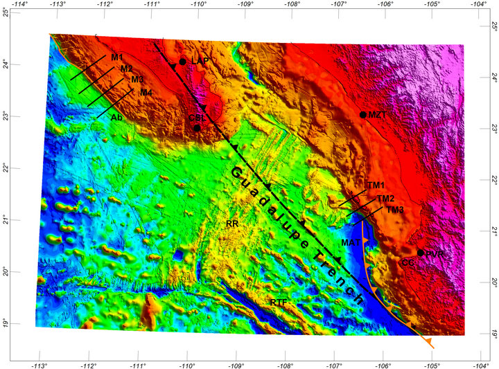
Figure 1. Past and present trenches in western Mexico: the abandoned trench (Ab) west of Baja California, the trace of the proposed, reconstructed, Guadalupe trench, and the terminus of the MAT as traditionally represented. Lines M1-M4 and TM1-TM3 locate the corresponding topographic profiles shown in Figure 7. RR Rivera Rise, RTF Rivera Transform Fault, CSL Cabo San Lucas, LAP La Paz, MZT Mazatlán, PVR Puerto Vallarta, CC Cabo Corrientes. Topography from the Global Multi-Resolution Topography (www.marine-geo.com).
Baja California, the trace of the proposed, reconstructed, continuous, Guadalupe trench, and the trace of the terminus of the MAT as usually represented. One implication of this representation of the MAT is that it favors the collision of neighboring sectors of the subducting slab, which would locally increase seismicity; instead, a marked reduction of seismic activity is observed in the area [18].
Re-construction of the continuous trench is performed by smooth extrapolation towards the NW, of the presently active trench SE of latitude 19.35˚, with a seconddegree curve that fits the trace of that portion. The constraints for the translation of Baja California to its position at Chron 4n.2 are: 1) that the present, abandoned trench coincides with the trace of the Guadalupe trench upon translation, and 2) that the abandoned and active trenches lay along the trace of that trench as close to each other as possible (i.e., not overlapping). Under such conditions the translation of BC is ~500 km in the SE direction (Figure 2), coinciding closely with previous re-constructions [2,9] that did not attempt to explain the presence of TMI.
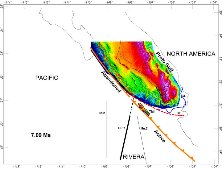
Figure 2. Palinspastic re-construction of BC to Chron 4n.2, when the Guadalupe trench was still continuous and subduction had stopped west of BC. Open triangles indicate the abandoned portion of the trench. The Tosco-Abreojos (T-A) fault was in place. The assumption is made that this was the time when BC began to separate from NAM. TresMarías Islands are shown as part of the continental shelf at that time, as proposed in here. The continental limit (CL) laid fairly close to the coast of Nayarit. Waters from the Pacific Ocean could feed the Proto-Gulf through a ~50-km wide sound (the Nayarit sound) between the coasts of Nayarit and BC. The dashed, red curve joining Banderas fault (BF) and the abandoned trench marks the path of a proposed channel (the Tosco-Abreojos-Banderas, T-A-B, channel) dividing BC to the north and TMI to the south. The channel may have started its development at ~14 Ma, when the Magdalena fan and Banderas fault began to form. This channel was probably the conduit to transport the eroded materials from the shelf to the trench, forming the Magdalena fan [14,25]. Isobaths for depths of 1000, 750, and 500 m (yellow) enhance the erosional imprint on the Magdalena shelf, west and south of the tip of the peninsula. The position of the EPR and that of Chron 5n.2, the oldest Chron recorded on the Rivera plate, are shown for reference, as well as the perimeter of the Present position of TMI. Extension to the north of the trace of the EPR coincides with the terminus of the T-A fault and the trace of the proposed T-A-B channel.
3. Tres Marías Islands Displacement
Herein I propose that at Chron 4n.2 Tres Marías islands occupied the position shown in Figure 2; they were part of the continental shelf and submerged. The following re-constructions span the period from 7.90 Ma to the Present. The general tectonic scenario at Chron 4n.2 was as follows. The Tosco-Abreojos fault (T-A F) was in place [19], constituting the limit between the Pacific and North America plates and right-lateral shear was acting across this fault. The position of the EPR at that time [20] referred to fixed NAM is also shown, as well as the position of Chron 5n.2, the oldest Chron (9.92 Ma) recorded in the Rivera plate, whose displacement evolution is an important reference in this re-construction. The topography of the islands is also shown for reference although they were submerged at that time; the perimeter of the present location of TMI is shown here and in subsequent figures as a reference. Major topographic trends indicate the existence of a sound between Bahía de Banderas and the peninsular territory, which would have allowed the connection of Pacific waters with the Proto-Gulf of California [1].
The continental limit (CL) of BC as defined in [21] extends beyond the peninsula (blue line around its tip) and lay fairly close to the present coast of Nayarit. The continental limit of the peninsula continued along the red, dashed line joining the Tosco-Abreojos fault, the abandoned trench, and Banderas fault. In [1] a similar line was inferred to exist at 10 Ma linking Bahía de Banderas with the trench south of Cabo San Lucas, while in [8] the Tosco-Abreojos fault was speculated to connect with the MAT south of ITM at 9 Ma. This line limits the continental shelf of BC to the north, and the TMI region to the south suggesting the existence of a channel. It terminates at the boundary between the reconstructed active and abandoned portions of the Guadalupe trench, connecting smoothly with the trace of Banderas fault as illustrated in the figure, and considered together they may have constituted a left-lateral shear system (Tosco-Abreojos-Banderas, T-A-B, shear system) along which BC began to separate from NAM.
The origin of Banderas fault was estimated at 14 Ma [22,23] making it contemporaneous with the Magdalena fan formation. The formation of the Magdalena fan was estimated to take place between 14 and 12 Ma, e.g., [24]; however, the precise mechanism of formation is still a matter of debate [25,26] and will be addressed in a separate paper. It is likely that the T-A-B shear system was active at that time. Present evidence of this channel is lacking since the shear system was progressively destroyed when the Tres Marías fragment began to displace northeasterly, as will be shown below. The continental (Magdalena) platform of BC facing this line shows clear signs of erosion all along this limit, enhanced by the irregular isobath shapes at 1000, 750 and 500 m depth (yellow), contrasting with the continental shelf further north that does not show such signs. This observation can provide a clue to the origin of the Magdalena fan since erosional denudation of the Magdalena shelf could have been channeled along this corridor, towards the trench, forming the fan. This is in agreement with a recent estimate [25] of dextral slip displacement of the fan along the trench of <150 km as well as with excellent matches of 120 - 65 Ma detrital zircons of the fan, and those of the Magdalena shelf. In this re-construction the ToscoAbreojos fault ends at the intersection with the trace of the T-A-B shear system. Since the NE extension of the EPR also reaches this intersection (dotted line) it suggests that when the EPR advanced northwards it may have created a Ridge-Transform-Trench triple junction, coinciding with previous descriptions of the location of such a point just after the Middle Miocene reorganization, e.g., [24,27,28].
3.1. Chron 4n.2
The assumption is made that BC started to migrate towards the NW at the time of Chron 4n.2; the active trench thrusted against the TMI block displacing it to the NE, and the active trench began to deform. The NW displacement of BC from the position at 7.90 Ma to the position at 6.73 Ma was 63 km at a rate of 54 mm/yr, while the NE translation of Islas Tres Marías was 17.5 km at a rate of 15 mm/yr in 1.17 My (Figure 3). The BC displacement is obtained from the displacement calculated in [20] of a point in the Rivera plate between Chrons 4n.2 and 3A.2 for fixed NAM. The restriction is that, in its translation to the NE, the position of the islands does not overlap the continental region of southern Baja California. The peninsula and the Tres Marías block sled past another along the T-A-B shear zone and the T-A fault was the boundary between the Pacific and NAM plates. As the active trench thrusted against the TMI block displacing it, the first fault with right lateral motion appeared on the SE side of the TMI block. A portion of the northwestern end of the T-A-B shear zone was destroyed by the advancing Tres Marías block and was probably substituted by a left lateral fault that connected the T-A fault with TMI. The Rivera plate occupied a small sector as indicated by the position of Chron 5n.2 east and west of the EPR. The positions of the EPR and the eastern branch of Chron 5n.2 were approaching the trench.
3.2. 6.0 Ma
An intermediate position between Chrons 3A.2 and 3n.4 at 6.0 Ma is shown, where BC had retreated further (Figure 4) and the TMI block continued advancing northeasterly to its new position. The left-lateral fault connecting the T-A fault with TMI grew larger. Along the active trench new right-lateral faults developed and an additional portion of the T-A-B shear system was destroyed. In this figure the positions of the EPR and Chron 5n.2 are inferred from those corresponding to Chrons 3A.2 and 3n.4 [20]. The trace of the traditional representation of the trench terminus is shown dashed for reference (MAT-P).
3.3. Chron 3A.2
At 5.12 Ma the EPR had penetrated the mouth of the Gulf (Figure 5) and a small segment (MR), the María Magdalena rise, was emplaced close to TMI [20,34]. TMI advanced to the position shown and the terminus of the trench was in touch with the tip of the MR. Another portion of the T-A-B shear zone was destroyed by the advancing TMI block leaving Banderas fault quite close to its present extension. Additional displacement blocks developed further to the SE, accommodated by right lateral displacements; dashed lines in that region indicate where additional faults would form subsequently. The motion of the Rivera plate was analyzed in [20]; displacement paths for points on the Rivera plate relative to NAM were reconstructed showing four paths of points between 17˚N and 22˚N in the period between 9.9 to 0 Ma. The four tracks follow NE trajectories of motion from 9.9 to 5.1 Ma. Figure 5 shows arrows labeled d corresponding to the motion of points in those positions between 9.9 and 5.12 Ma [20]. Although the trajectories are somewhat oblique to those proposed for the displaced blocks, the general trend coincides. A 30˚ change in orientation of Banderas fault and the axis of Banderas Valley, the continuation inland of Bahía de Banderas, was
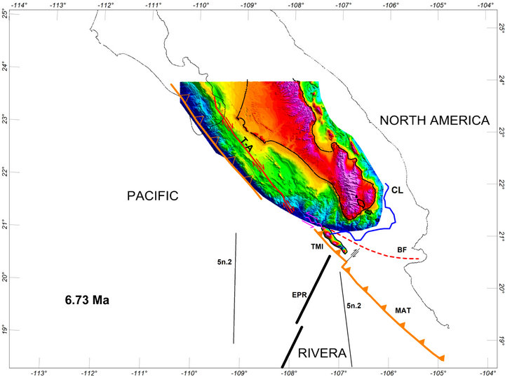
Figure 3. Positions of Baja California and Tres Marías Islands at Chron 3A.2. BC and TMI sled past another along the Tosco-Abreojos-Banderas channel. The NW displacement of BC from the position at 7.90 Ma to the position at 6.73 Ma was 63 km at a rate of 54 mm/yr, while the NE translation of Islas Tres Marías was 17.5 km at a rate of 15 mm/yr in 1.17 My. Starting at 7.90 Ma part of this channel was destroyed by the advancing active trench and TMI block. The destroyed portion may have been substituted by a left-lateral shear zone joining TMI with the terminus of the T-A fault. The first right-lateral fault appeared SE of TMI and the deformation of the active trench began. The positions of the EPR and Chron 5n.2 approached the trench.
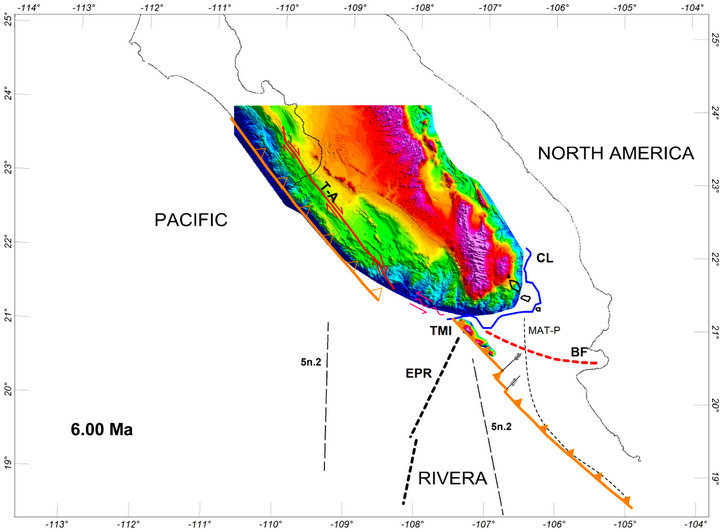
Figure 4. Positions at 6.0 Ma of BC and TMI between Chrons 3A.2 and 3n.4. The EPR and the terminus of the active trench were in contact or very close, creating a region of oblique subduction. Additional right-lateral faults appeared along the active trench and another portion of the T-A-B channel was destroyed. The traditional trace of the terminus of the MAT (MAT-P) is shown for reference. The positions of the EPR and Chron 5n.2 (dashed) are inferred from those of Chrons 3A.2 and 3n.4.
noted [29] and attributed to an extensional process estimated to initiate at ~5 Ma [23]. Thus, this change in orientation apparently occurred contemporaneously with the initiation of displacement of the easternmost blocks at the trench suggesting a causal effect between them. If extended northwesterly, the small transform fault linking the MR and the main body of the EPR continued along the proposed left-lateral shear zone, connecting with the terminus of the T-A fault, suggesting this line probably represented the limit between the Pacific and NAM plates at that moment. At this time the boundary between the Pacific and NAM plates was about to be transferred to the interior of the Gulf.
4. The Fault System
Figure 6 shows the Present position of the TMI fragment including the vicinity of the terminus of the trench divided in sectors. Some of these sectors penetrate Bahía de Banderas (BB), the 60 km incision of the continent that was proposed as the NW limit of the Jalisco block [29], and coincide with previously identified faults in and around the bay [22,23,30]: Cucharitas-Pitillal fault (CPF), Cabo Corrientes-Bucerías-El Colomo fault (CCBCF), Marietas-Punta Mita fault (MPMF), and Corbeteña fault (CF). This indicates that the normal faults previously identified inland continue offshore, which is corroborated in various places by topographic profiles. However, additional faults not previously identified are spread offshore to the NW, reaching to the TME: El Bajo fault, (EBF), No Name fault (NNF), and María Magdalena fault (MMF). Preliminary, gravimetric and aeromagnetic modeling suggests they are also transcurrent, normal faults (article in preparation). In this interpretation, the terminus of the trench consists of a series of former continental shelf blocks that have been displaced towards the NE from their original positions along the Guadalupe trench. The amount of NE displacement of these blocks