Shallow Reflection Surveys of the East Ongul Island, the Lützow-Holm Complex, East Antarctica ()
1. Introduction
Deep Seismic Surveys (DSS) by active sources in continental crusts have been conducted in a lot of geological terrains over the last few decades. From the 1990’s particularly, several refraction/reflection DSS in Precambrian terrains have demonstrated the details of continental growth [1] . Characteristic features of the delaminated lower crust and its subducting architecture into mantle lithosphere were clearly identified in the Archaean and Proterozoic terrains of the Canadian Shield [2] [3] . At both the polar regions, however, have not been intensely investigated by modern high-resolution imaging. After the 1990’s, several near-vertical reflection surveys for imaging the shallow crust were conducted in West Antarctica and Antarctic Peninsula [4] [5] . However, active source seismic surveys over the continent covered by thick ice sheets still remain a great challenge, especially in East Antarctica.
East Antarctica consists of several crustal terrains which are the resultant of amalgamation and breakup of Rodinia and Gondwana super-continents. In the wide areas of Western Enderby Land—Eastern Dronning Maud Land, four distinct Complexes are adjacent from East to West: the Napier (Archaean), the Rayner (late-Pretero- zoic), the Lützow-Holm (LHC; early-Paleozoic) and the Yamato-Belgica (early-Paleozoic) [6] . Late Proterozoic structures are interpreted to have caused initial uplift and exhumation of the Archaean Napier, where the oldest metamorphic rocks found are approx. 4000 Ma [7] . Combined with other Gondwana continents such as Australia [8] , architecture and relevant tectonic history of the Antarctic crust provide insight to amalgamation and separation of super-continents.
The LHC, where the Japanese permanent Station (SYO, 69S, 39E) is located, has been regionally metamorphosed in early-Paleozoic [9] . Metamorphic grade increases progressively from amphibolite facies in eastern part to the granulite facies in western part of LHC (Figure 1). The transition zone between amphibolite and granulite facies is located in the central part of LHC, and is defined as a first appearance of orthopyroxene in ordinary basic to intermediate gneisses. During the Pan-African metamorphism, the LHC was deformed under compression stress perpendicular to the thermal axis (parallel to the coast) [10] . The Gondwana began to break- up in relation to the Antarctica/Australia-India rifting around 150 Ma when the LHC was supposed to be in an extensional stress state inducing uplift of mantle material and associated under-plating [11] .
The shallow reflection surveys were carried out in 2007 and 2010 austral summers in East Ongul Island, where the Station SYO was located, in the central part of LHC. The reflection surveys targeted to obtain the images of laminated layering of metamorphic rocks in the surface (down to few hundreds of meters) of the crystalline crust. The shallow reflection surveys might give rise to information for understanding tectonic formation of the LHC. In this paper, outline and results of the shallow reflection surveys in East Ongul Island are demonstrated and the considerable shallow structure is discussed.
2. Previous Deep Surveys in LHC
In austral summer in 2000, DSS was conducted on the continental ice sheet of the northern Mizuho Plateau of the LHC (Figure 1) as the interdisciplinary program of “Structure and Evolution of the East Antarctic Lithosphere (SEAL)” [12] . A total of 3300 kg in dynamite charges was detonated at seven shot points along the Mizuho traverse routes generating enough seismic energy to acquire information about regional velocity models and the characteristic reflectors. An wide-angle travel-time analyses of the SEAL-2000 data had revealed the crust-mantle boundary (the Moho) with varying from 38 to 42 km along the profile, together with P-wave velocities in the upper, middle, and lower crust and uppermost mantle, as 6.2, 6.4, 6.5 and 8.0 km/s, respectively [13] .
The second DSS was carried out on the Mizuho Plateau in 2002 austral summer, with its profile parallel to the coast (NE-SW; SEAL-2002) (Figure 1). The seismic profile was perpendicular to the SEAL-2000 profile so as to obtain the difference in subsurface structure between the corresponding areas with granulite and amphibolite facies which appear in outcrops along the coast. In both surveys in 2000 and 2002, over 160 number of 2 Hz vertical geophones were installed on the ice sheet with 150 km in length. The SEAL-2002 transect gave velocities in the surface layer of the crystalline crust varying between 5.9 - 6.2 km/s, which appears to correspond to the changing in metamorphic grade of the surface geology from amphibolite to granulite facies [14] .
Reflection images of the deep structure in LHC were also obtained by using the same dataset of SEAL-2000 and -2002 profiles [15] . Processing of the DSS data has produced enhanced reflection images of the Moho and of the internal crustal structure. Laminated layering around the Moho was imaged using coherency enhancement
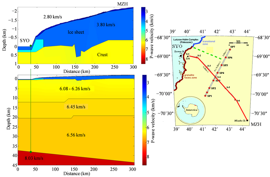
Figure 1. (Left) P-wave velocity model of the crust, uppermost mantle, and the overlying ice sheet on the Mizuho Plateau, derived from refraction experiments by the SEAL-2000 DSS (modified from Yoshii et al., 2004). The average depths of the discontinuities between the upper and lower crust (Conrad) and between the lower crust and upper mantle (Moho) are 20 km and 40 km, respectively. (Right) Location of the DSS profiles on the Mizuho Plateau. The SEAL-2000 profile is indicated by the red line, which was the same location as the Pre-SEAL DSS in 1980. The NE-SW seismic profile (SP1-SP7) indicates the DSS conducted by SEAL-2002.
processing after Normal Move-Out (NMO) corrections applied to far-offset data. The repetitive crust-mantle transition zone by SEAL-2002 suggests the presence of compression stress in a NE-SW orientation during the Pan-African, which occurred at the last stage of formation of a mobile belt between East and West Gondwana [16] . Successive break-up of the super-continent in mid-Mesozoic could account the formation of stretched reflection structure above the Moho as imaged in SEAL-2000 profile.
Since the station intervals for previous SEAL-DSS were rather large about 1 km, therefore, higher reflection images could be expected when adopting denser station intervals with high resolution acquisition systems. The technique used for the near-vertical reflection surveys in this study with high space resolution might be a crew to the new expansion for larger scale exploration over the Antarctic continent in future.
3. Shallow Reflection Surveys in East Ongul Island
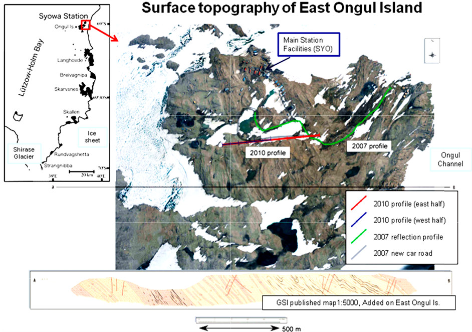
Two shallow reflection surveys were conducted in 2007 and 2010 austral summers in total length of profiles in 500 m along a main traffic load, which across in the middle of East Ongul Island almost an orientation from West to East (Figure 2(a)). The East Ongul Island has very small land area with its diameter about 1 km, and the permanent Japanese station Syowa (SYO, 69S, 39E) is located in the middle north of the Island.
The surface outcrops are composed of metamorphic rocks with their lithological layered structure. The main composition appearing on surface bedrocks is mainly consisted from hornblende gneiss, garnet gneiss, metabasite and pyroxene gneiss, from the western part to the eastern part of the Island (Figure 2(b)). Actually, a majority of central parts in the Island are occupied by garnet bearing felsic gneiss (the garnet gneiss). From the evidence of structural geology, moreover, eastward dipping layers were speculated in geological map of the Island. In addition to the existence of fault systems, intrusion of pegmatite can be recognized over the Island. Two
 (a)
(a) (b)
(b)
Figure 2. (a) Surface tomography of East Ongul Island by the Geodetic Survey Institute (GSI), together with seismic profile for shallow reflection surveys. The lower panel shows the geological cross section by the National Institute of Polar Research (NIPR) in 1974; (b) Surface geology of East Ongul Island (NIPR in 1974), together with seismic profile for shallow reflection surveys.
seismic profiles for shallow reflection surveys lies on the middle part of the Island, where the dominant composition of surface rocks are the garnet gneiss and metabasite.
3.1. Operation in 2007 Austral Summer
The survey in 2007 was carried out in austral summer between January 20 and 23. A total length of the seismic profile was about 800 m orienting in EW (Figure 3). A 29 channel acquisition system was utilized by using dense vertical geophones with spatial interval of 40 m, and the intrinsic frequency of the geophones was 4.5 Hz (type GS-11). The AD acquisition sampling was applied for 4 msec by using the off-line data loggers (type MS2000). The seismic sources in 100 m interval were utilized by hitting a boom tip of an oil powered shovel car to the ground surface, by accomplishing six stacking times for a point. The position of each geophone stations and source locations were determined by a hand type GPS receiver with its space resolution of a few cm. The field observation parameters and survey photographs are listed in Figure 4.
Examples of record sections for two way travel times (SP03 and SP07) are shown in Figure 5. The obtained data include clear first P-arrivals in far offset distance. An energy of the P-S converted waves was significantly enhanced because of the characteristics of the seismic sources by using the boom hitting of the oil powered shovel. Pre-stacked seismic data could give rise to an efficient information about metamorphic layering of lithological structure appearing on the surface bedrocks. In data by SP07, a reflected phase is recognized in eastern part of the profile. This phase assumed to be caused from the reflection in vicinity of the East Ongul Islands, particularly associated with fault system along the coast of Island and adjacent Ongul Channel.
3.2. Operation in 2010 Austral Summer
The survey in 2010 was carried out in austral summer between the period in February 2 and 9. A total length of the seismic profile was about 300 m in EW direction, where was the western half of seismic profile in 2007 (Figure 2). A 24 channel acquisition system was utilized by combining dense vertical geophones with spatial interval of 12.5 m, with their intrinsic frequency was 30 Hz (type SM-11). The AD acquisition sampling was
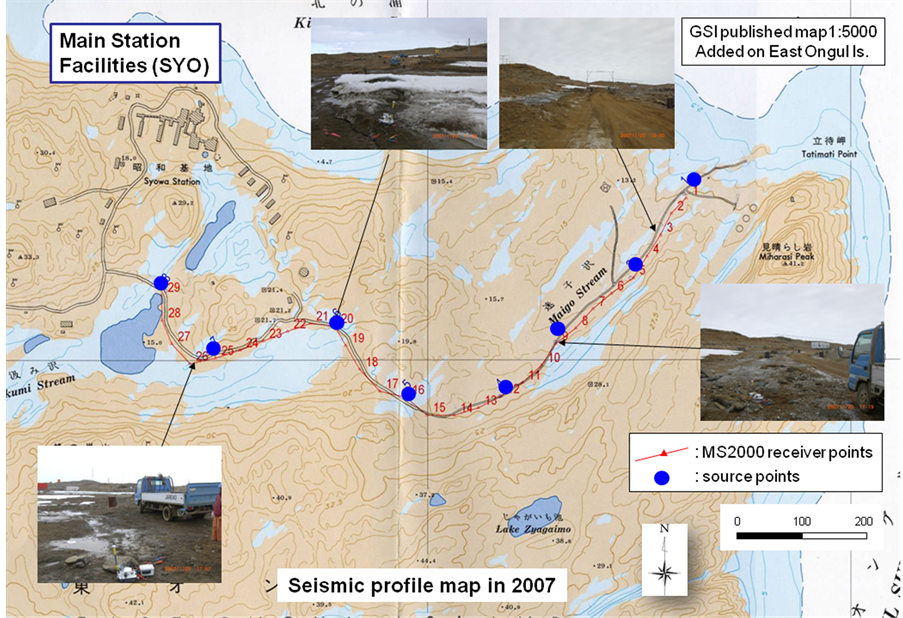
Figure 3. Detail map of seismic profile in 2007 of East Ongul Island, with several photographs of the survey.
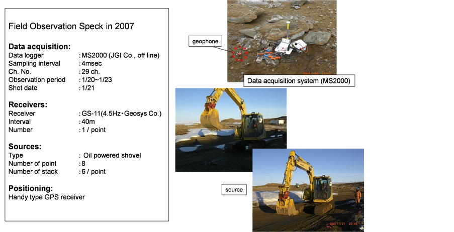
Figure 4. Field observation parameters of 2007 survey (left) and related photographs (right).
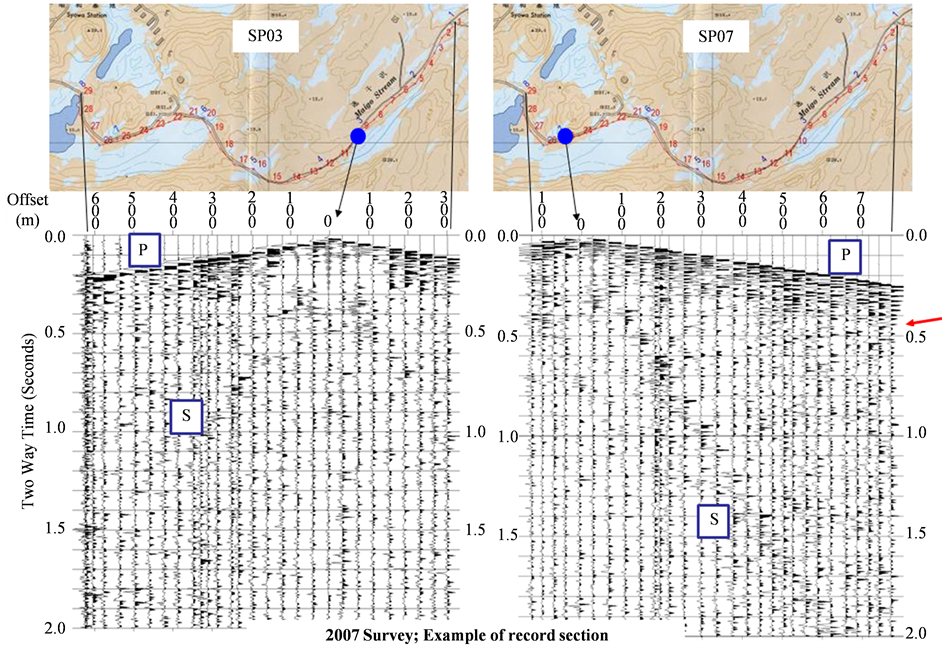
Figure 5. Examples of record sections (two way travel time) for 2007 survey (left; SP03, right; SP07). The red arrow in Sp07 indicates the reflection wave.
applied for 0.5 msec in order to identify the detailed structure of laminated layers in basement metamorphic rocks (for an averaged P-wave velocity of 6 km/s). A digital telemetry system (DAQ Link II) was adopted to retrieve the shot gathers. Seismic sources in 25 m interval were utilized with combining a weight drop (40 kg, 5 times stacking for a point) and the hammer shots (20 times stacking for a point). The position of each geophone stations and source locations were determined by a hand type GPS receiver with its space resolution of a few cm. The field observation parameters and survey photographs are listed in Figure 6. A configuration of block diagram of the observation system for 2010 survey is shown in Figure 7.
An example of the record section for two-way travel times is shown in Figure 8. This is the stacked traces for SP21 point. The stacked energy was rather small in the survey, unfortunately, there are not so significant phases appeared except for the first arrival P-phases.
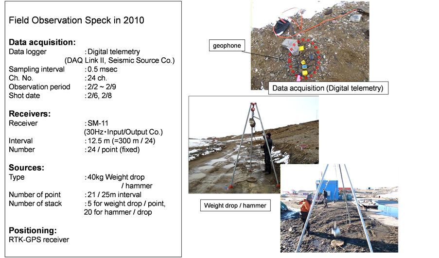
Figure 6. Field observation parameters of 2010 survey (left) and related photographs (right).

Figure 7. A block diagram of the observation system for 2010 survey.
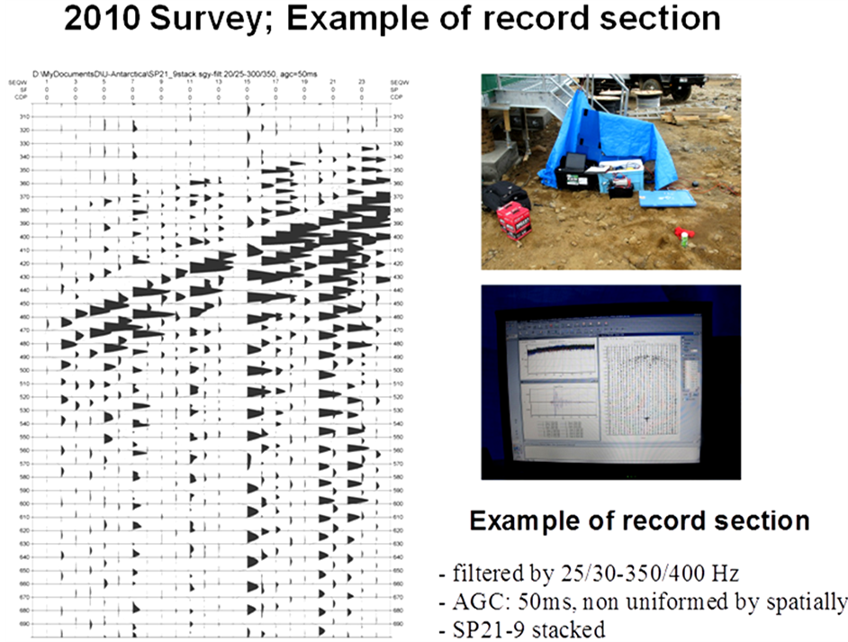
Figure 8. An example of record section (two way travel time) for 2010 survey (left) and related photographs (right).
4. Discussion
Pre-stacked shallow reflection data could give rise to an efficient information about metamorphic layering of several lithological structure in East Ongul Island. On data by SP07 in 2007 survey, a reflected phase was identified in the eastern part of the profile. The phases assumed to be caused by reflections in vicinity of East Ongul Islands, plausibly associated with the buried fault along the coast of the Island. Otherwise, the phase came from more eastward adjacent area such as the Ongul Channel, between East Ongul Island and the Antarctic continent. Unfortunately, however, identical clear reflection phases could not be detected in 2010 survey.
Regarding the detection of metamorphic layering composed of several rock types appeared in the surface, such as by hornblende gneiss, garnet gneiss and pyroxene gneiss, might be rather difficult only from the present dataset by small source energy with limited logistic supports. The seismic energy generated by staking procedures from these conducted surveys might not penetrate into the enough depths in order to detect the targeted lamination structure of the metamorphic rocks. The surveys in this study might be one step to develop more high-powered generating systems in future so as to deploy effective surveys in outcrop areas in Antarctica or similar environment condition in any continental margins.
Table 1 present physical properties for bulk density, porosity and major mineralogical constituents of the surface rocks of the drilled core at East Ongul Island [17] . On the basis of these physical information of the metamorphic rocks, several pairs of acoustic impedance, reflection coefficients are calculated (Table 2) for representative metamorphic rock types chosen from Table 1. The P-wave velocities (Vp) for each rock types are reduced from the density—Vp relationship of the Birch model [18] . From Table 2, the reflected wave amplitudes from acoustic impedance boundaries between magnetite rich felsic gneiss and other rock types, as well as garnet gneiss and felsic gneiss could be the most detectable pairs in the topmost crust of East Ongul Island.
Table 1. The bulk density, apparent porosity and major mineralogical constituents of the sample rocks of the drilled core at East Ongul Island (after Yukutake and Ito, 1984).
Table 2. List of bulk density, Vp, acoustic impedance and their pairs of reflection coefficients for major metamorphic rock types from East Ongul Island. The rock sample type numbers are from Yukutake and Ito (1984). Considerable rock types corresponds to the surface geology are notated in the Remarks.
As there are no information on physical properties by direct drilled cores for pyroxene gneiss, metabasite and pegmatite, we do not mention here about the reflection characteristics involving these rock types. Actually, locations of the drilled cores retrieved by Yukutake and Ito (1984) distribute along the seismic profiles both in 2007 and 2010, at the central part of East Ongul Island. Therefore, the main composition of rock types may be limited on discussion about the reflections from the boundaries between felsic gneiss and garnet gneiss.
In contrast, high-pressure laboratory measurements up to 1 GPa for felsic gneiss and biotite-bearing granulite from LHC [19] support the observed seismic velocities in the uppermost crust (6.1 - 6.2 km/s) determined by SEAL-DSS [13] . Crustal reflection layers have been found majorly in lower part of the crust, where has been considered to represent multi-genetic origins, including igneous intrusions, lithologic and metamorphic layering, mylonite zones, shear zones, seismic anisotropy and fluid layers [20] . Although the cause of crustal reflectivity may be of multi origins, it is supposed that metamorphic layering could be the principal candidate in LHC. A relatively high reflectivity in the middle-lower crust could be supposed from layered sequences of mafic rock (pyroxene granulite) and felsic gneiss [21] .
Recently, the vibrator systems had been working over the Ekstrom Ice Shelf, so as to detect the detail image of bedrock topography beneath the ice shelf [22] . They used a truck-mounted Failing Y-1100 vibrator (peak actuator force equivalent to 12 tons) on skis towed by a Pisten-Bully snowcat on the floating Ekstrom Ice Shelf near the German research station Neumayer. The shot gathers data are compared with those by using explosives source, and found the similar resolution for several reflection waves. When bringing such large vibrators in Antarctic outcrops as well as on the ice sheets, more detail crustal images of reflection can be achieved. In addition to the existing fault systems in vicinity of the Island, intrusion of pegmatite could possibly be detectable in future study by using larger energetic seismic sources.
5. Conclusion
Shallow reflection surveys were carried out in 2007 and 2010 austral summers in East Ongul Island, the LHC, East Antarctica. The multi-channel reflection surveys with several manual seismic sources targeted to achieve the image of laminated layering of metamorphic rocks on the surface of crystalline crust. The two surveys were conducted in total length of the profiles in 500 m along a main traffic load across the Island. The obtained pre- stack data include clear first P-arrivals in far offset distance. The energy of P-S converted waves was significantly enhanced because of radiation characteristics of the seismic sources. Pre-stacked data could be one of the steps on revealing characteristics on metamorphic layering of several lithological structures. On the basis of physical information of the surface bedrocks, several pairs of acoustic impedances, reflection coefficients were estimated for major components on metamorphic rock types. Moreover, the fault systems in eastward of the Island were recognized on the pre-stack data. The shallow reflection surveys conducted in this study would give rise to a proxy for understanding the tectonic formation of LHC, as one of the Pan-African mobile belts in Gondwana super-continent.
Acknowledgements
The authors would like to express our appreciation to the participants of the shallow reflection surveys in 2007 and 2010 by the Japanese Antarctic Research Expeditions. The authors would like to express sincere thankfulness to Prof. K. Shiraishi, a Director General of the National Institute of Polar Research, together with other staffs of geoscience group for their useful discussions about geological and geophysical information on LHC.