Scientific Analysis of Adding Weather Heat Capacity °Ch in the Weather Forecast ()
1. Foreword
Modern weather forecasting has over 150 years of history, which is a result of the development of modern science and technology. Weather forecast plays an important role in people’s lives, industry, agriculture, national construction and military build-up. And it is closely related to our people’s daily life. The dependence of people on the weather forecast is enhancing now.
Because human life has been affected by the weather, therefore human beings start to predict the weather from the prehistoric till now. Around 650 BC, the Babylonians used a cloud-like shape to predict the weather. In 340 BC, Aristotle in his “Meteorologica” described many different kinds of weather conditions. About 300 BC in China, there existed a record of weather forecast. For example, 24 solar terms in ancient China is actually a weather forecast. From the 17th century, scientists began to use scientific instruments (such as barometer, thermometer) to measure weather conditions and to make weather forecasts. However, the reason why people only use local meteorological data in a very long time to do weather forecast is that the data not timely transfer to a remote area. To solve this problem, people think up various solutions. The telegraph was invented in 1837, which took a strong measure to tackle the pressing problem. After 1837, the technology of telegraph is developing by leaps and bounds, making it possible for people to use a large amount of meteorological data for weather forecast than ever before. In 1856, France founded the world’s first formal system of weather forecasting services. In the 20th century, the digital weather forecast was born and had been gradually developing under the rapid developing environment of satellite, computer technology and meteorology. Finally, leading digital weather forecast to works as the main way in contemporary weather forecast [1] .
2. Question
2.1. Controversy Triggered by the “Stove” City Ranking
With the advent of summer, everywhere on the land of China people are complaining about the heat. We are often hear a few people or even a dozen people involved in the controversy of four “stoves city” on the train, plane, ships, airports, railway stations, bus, streets, shopping malls and campus. But no one can reach a conclusion. So which are the four “stoves city”?
One view about four “stoves city” is Nanjing city, Wuhan city, Chongqing city, Changsha city.
One view about four “stoves city” is Nanjing city, Wuhan city, Chongqing city, Nanchang city.
One view about four “stoves city” is Nanjing city, Wuhan city, Chongqing city, Xi’an city.
With global warming, temperatures in some mainland cities also increased, adding themselves to the “hot club” to compete for the four stoves in China’s cities, for example: Shijiazhuang city/Hefei city/Zhengzhou city.
To solve this problem, can we have a quantitative approach to give the answer? Solving the real “stove” city ranking and people’s confusion?
2.2. Why Do We Feel Hot When the Temperature Is Not High?
In summer we often feel muggy when the temperature is not that high. On the contrary, although the temperature is actually high in some day, we don’t feel the hotness. So why do we feel this way? Could the weather forecast be wrong?
Such as, on July 28th 2010, Lanzhou city’s temperature between 21˚C - 39˚C, Xi’an city temperature between 27˚C - 37˚C, the highest temperature of Lanzhou is 2˚C more than that of Xi’an. But living in Xi’an, people obviously feel hotter than Lanzhou.
Such as, on June 9th 2012, Xi’an temperature between 21˚C - 36˚C. On July 17th 2012, Xi’an temperature between 25˚C - 36˚C [2] , the same previous highest temperature, but people’s feel of July 17th is obviously hotter than June 9th. Why? If one do not consider the impact of air humidity and wind but temperature, how to answer people’s confusion? In summer we often encounter this problem, that is someone says today’s weather is too hot to stand; another person says, not too hot, the hottest day was yesterday; one person says, neither this two days are not the hottest but the day before yesterday. Why different people feel such a big different (In these three days, the same as the air humidity and no wind), and the key is the lack of a unified scientific criteria, which leads to people’s dispute of the hottest days.
In summer, enterprises of highest temperatures cities should pay high temperature allowance to employees. Some outdoor work projects are to be suspended in high-temperature days. It is not scientific and discrete to judge by the highest temperature of the day. Can one give a more scientific basis?
2.3. Summer/Winter Temperatures Evaluation, One of the Most Ignored Temperatures
As the summer of June, July, August, hot on the land of China become one of the hottest topics, weather forecast and the news media have reported the highest temperature of the day. It was agreed that the highest temperature of the city is the hottest city (in fact, this is an error). The people only care about the highest temperature, very few people care about the low temperature. 60% of the people recognize the highest temperature of the day, but 99% of people do not know the day’s lowest temperature; low temperature was easy to be neglected. I found, in this summer, the city with the highest low temperature is the hottest one. When everybody else is concerned about the highest temperature of a city, I care about which city low temperature was lift up. Figures 1-3 is Xi’an temperature curve charts in 2012 [3] , June, July and August, the hottest months. Clearly from the table, the curve of low temperature gradually raised, is the main factor in one month is warmer than another month.

Figure 1. Xi’an June 2012 weather temperature curve charts.

Figure 2. Xi’an July 2012 weather temperature curve charts.

Figure 3. Xi’an August 2012 weather temperature curve charts.
Similarly, in winter, people and news media focus on the lowest temperature, highest temperature was ignored. Is there a way to solve some critical temperature point ignored?
3. Current Weather Forecast Analysis of Defects in Temperature Forecasts
In current weather forecast, the temperature forecast only do an extreme forecast. Forecasting temperature maximum value (Max) and minimum value (Min), but on the whole temperature curve only two extreme points were forecasted, and most temperature points do not included, other temperature points can only depend on our personal feeling. This is a one-dimensional temperature forecasts just have the space without time, which does not meet the “time and space” philosophical view. Figure 4 describes a city in spring, summer and winter temperature someday charts, which located in northern China. The advantages of extreme forecasts are simple, intuitive, convenient, high maneuverability. It has been used widely in the whole world, not only are all the cities in China but also in New York, Washington, Los Angeles, Dallas, Chicago, Colorado Spring, Las Vegas and other cities, having adopted such forecasts way. In addition, London, Glasgow, Edinburgh, Portsmouth, Coventry, Japan, Singapore, Hong Kong, Macao and Taipei are also using this kind of forecasts method.
4. The Scientific Analysis of Weather Forecast Add Heat Capacity Forecast Items
4.1. The Necessity of Weather Forecast Introduced Heat Capacity (˚Ch)
In order to solve the problem of the highest temperature of the day is not the hottest day. In order to settle the issue of the lowest temperature of the day is not the coldest day. In order to work out the problem of the “four furnaces” of China in the summer controversy cities ranked. In order to tackle the coldest cities and hottest cities ranked problem in the world. In order to the government provides a more scientific criterion for high-temperature outdoor work stoppage. In order to the government provides more scientific criterion for high-temperature subsidy. In order to figure out these most controversial issues, the simply way is that addition heat capacity (˚Ch) physical item, to work as an important meteorological parameters to forecast , perhaps all of the above problems and controversy can be solved. After introduction of the heat capacity (˚Ch) physical item. Human will find many benefit, it can be used to judge the degree of hot and cold weather. It can be used to determine whether we need add or reduce clothes in day. And, it can be used for all the city’s hot and cold sorted by day, monthly, quarterly, year-on-year. Of course, it can be used to serve the industrial, agricultural, military projects, the heat capacity to judge more scientific than simply using the high and low temperature weather.
4.2. How to Test and Calculated Weather Heat Capacity (˚Ch)
From Figure 5, the weather temperature is constituted by the time of the X-axis and temperature of the Y-axis. The current weather forecast only reported the Y-axis the highest and lowest temperature, the correspondence relationship of temperature and time (the enclosed area of the timer shaft and temperature curve) is not reported.
Figure 5 is a graph about weather temperatures in early spring on one day a certain place. Seeing from Figure 5, the weather heat capacity (˚Ch) is the integral of temperature and time, that is sum of the areas A, B, C of the three regions in Figure 5. In the picture, the weather heat capacity (˚Ch) of blue region is negative value, the weather heat capacity (˚Ch) of the red region is positive, A/B/C three area added value is the heat capacity (˚Ch) of this place on one day. If you want to know a place heat capacity (˚Ch), you should add the region A, region B, region C together.
Figure 6 is somewhere summer weather temperature curve, from the figure, the value of weather heat capacity in this place (˚Ch) is red (positive). If the weather forecast have heat capacity item (Figure 6, the full value of the area of the red zone), the relation between weather forecast and the feeling of the people would correct. Current weather forecast only report two extreme points (in Figure 6) on the red zone, it is the typical “point on behalf of area” that leading to bias between what the people feeling and the weather forecast.
Figure 7 describe a weather temperature curve about one place a day, in the figure, the value of the weather heat capacity (˚Ch) are negative(green area) in this place.
For any temperature curve T = f (t), shown in Figure 8, its weather heat capacity (˚Ch) is area surrounded by the curve T = f (t) and time t shaft. Using the integral method to calculate the heat capacity value that day weather:
 (1)
(1)
HC (Heat capacity) of physical unit: ˚Ch t is the hour˚C is the degrees Celsius.
t1 is the beginning of time, generally taken to be 0:00.
t2 is the end of the time, the general value of 24 hours.

Figure 4. Current use of weather temperatures (extreme) forecast graph.

Figure 5. A place one day in early spring weather temperature graph.

Figure 6. Summer day, somewhere, sometime weather temperature graph.

Figure 7. A place one day in winter weather temperature graph.

Figure 8. Any weather temperature graph.
t1 - t2 interval can be a day, a week, a month, the quarter, a year, the unit is hours.
Using a computer to simulate curve equation T = f (t), after that, the integral Equation (1) can be used to calculate the weather heat capacity. Other approximate method can be used to calculate the shadow area of the temperature and time too. We are located in advanced computer times, if there owns much detailed records about temperature and forecast, it would not difficult thing that we can calculate the weather heat capacity.
4.3. How to Use Heat Capacity (˚Ch) Meteorological Indicators
4.3.1. The Calculate Method of “Four Stoves City” in China
June, July and August is the hottest three months in the whole year, so we calculate Shijiazhuang, Hefei, Zhengzhou, Xi’an, Nanjing, Wuhan, Nanchang, Changsha the sum of Jun, July and August the daily heat capacity. Ranking the top four cities according to the daily average of heat capacity and total value, which is China “four stoves city”. Due to the lack of meteorological data, I cannot accomplish this work. However, we can get the help of the meteorological records data from the Bureau of Meteorology and advanced computers to achieve this job done.
4.3.2. Calculating the Hottest Place in the World (Daily Highest Heat Capacity of the Places)
Where is the hottest place on earth, everybody confuse about that. According to the United States National Aeronautics and Space Administration satellite monitoring Lute desert located in Iran the records on August 1th 2009, there was a high temperature of 71˚C [4] . Therefore, the hottest place on the earth was undoubtedly belonging to Iran Lute desert. If the temperature continues 24 hours in a day, the Lute desert heat capacity would be the maximum value of the heat capacity on the earth:

4.3.3. Calculating the Coldest Place in the World (the Lowest in the Heat Capacity per Day)
The recorded minimum temperature is −89.4˚C [5] on the earth, measured in 1983 at the Russian Antarctic station. If the temperature continues 24 hours in a day, the heat capacity of the Russian Antarctic station would be the minimum heat capacity on the earth:

Seen from the above calculation:
−2145.6˚Ch ≤any region daily heat capacity of the earth ≤1704˚Ch.
4.3.4. Calculating the Round Spring Heat Capacity Value Range
When the temperature between 20˚C - 25˚C, people have feeling like spring. Assuming this temperature continues for 24 hours a day, we can calculate the heat capacity value range of season likes spring:
Lower limit:20˚C × 24 h = 480˚Ch Upper limits:25˚C × 24 h = 600˚Ch Seen from the above, when the heat capacity of 480 - 600˚Ch, people feel like spring.
4.3.5. Using Heat Capacity to Assess the Degree of Carbon Dioxide Emissions That Cause Global Warming, Called Greenhouse Effect
The heat capacity assesses the climate warming more precise, scientific and comprehensive than temperature assessment. If you want to know it exactly, first you should select a place, then calculate the place full year average heat capacity, finally use the value to comparing with the value of 10, 20, 30, 40, 50 years ago.
4.3.6. We Use the Heat Capacity to Calculate the World Main City Heat Capacity on August 1th in 2012. Shown in Table 1 [6]
Note: In Table 1, Heat capacity should be based on the temperature profile on August 1th, 2012, using the formula (1) to obtaining the major cities’ heat capacity. To simplify the description, I choose 24-hour average value. This kind of way has a discrepancy is less accurate than integral. In the real weather forecast we should do integral computation. Here is just a rough show-and-tell.
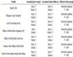
Table 1. The heat capacity of the world’s major cities on August 1, 2012.
4.3.7. Let Heat Capacity Answer a Lot of People Confusions
Confusion 1: Such as, on July 28th, 2010, Lanzhou city temperature between 21˚C - 39˚C, and Xi’an city between 27˚C - 37˚C, Lanzhou to Xi’an, although the highest temperature is higher 2˚C, people who live in Xi’an obviously feeling much hotter than Lanzhou, why?
Answer: The reason is Xi’an heat capacity bigger than Lanzhou, on July 28th 2010.
Confusion 2: Such as, on June 9th 2012, Xi’an temperature between 21˚C - 36˚C. On July 17th 2010, Xi’an temperature between 25˚C - 36˚C. The same as the two days high temperature is 36˚C, but people feel July 17th is obviously hotter than June 9th, why is it?
Answer: Because the day on July 17th 2012 heat capacity is bigger than June 9th 2012.
4.3.8. The Criterion about High Temperature Subsidy/Outdoor Work Stoppages in Summer Condition
Personally think, when a city daily average temperature reach 30˚C, we can get the heat capacity approximate to 720˚Ch, the people who work in high temperature should enjoy subsidies.
Personally think, when a city daily average temperature reach 35˚C, we can get the heat capacity approximate to 840˚Ch, all outdoor jobs in the city already have reached downtime standard.
5. Conclusions and Recommendations
5.1. Conclusions
1) In the current weather forecast, temperature curve extreme points (maximum and minimum temperatures) forecast only have “space”, does not have the time, it does not comply with the time and space. It is the typical “point on behalf of area” that can not represent the real situation.
2) If the heat capacity (physical quantity ˚Ch) is introduced to the weather forecast, the weather forecast would vary from the one-dimensional temperature upgrade to a two-dimensional area of heat capacity forecast. The two-dimensional area is representing the real weather situation, more accurate and scientific than before. The largest heat capacity day, also is the hottest day. The smallest heat capacity day, also is the coldest day.
3) Using heat capacity to explain and judge many kinds of weather phenomenon more simple, scientific and reasonable than use temperature.
4) Heat capacity (˚Ch) has many practical values in real life, which waits to be developed.
5.2. Recommendations
1) In the current weather forecast is best to continue using the day temperature curve extreme points (maximum and minimum temperatures) forecast for respecting people’s traditions and customs.
2) Addition the heat capacity (˚Ch) weather unit in current weather forecast.
3) Let heat capacity (˚Ch this physical quantity) use in the field of meteorology scientific researches.
4) Let the heat capacity (˚Ch physical quantities) continue to expand in practical field, to serve the people’s daily life than ever before.
5) Welcome scientific and technological workers to discuss the introduction of the heat capacity (˚Ch physical quantities) necessary and scientific.
6) If it is scientific that the weather forecast is introduced into the heat capacity (˚Ch), the weather may add the heat capacity forecast project. So as to make it better for human services, it may better to put it into spreading and practice all over the world.
Acknowledgements
The article translated by Wang Yile.