Patterns of Urban Compactness: Indicators of Balance between Built-Up Area and Voids ()
1. Introduction
1.1. Research Problem
The goals of containing and reversing land take in the coming decades, in compliance with international guidelines such as the Sustainable Development Goals (SDGs), defined in 2015 by the United Nations Global Agenda for Sustainable Development for 2030 ( Barbier & Burgess, 2017 ; Leal Filho et al., 2018 ), and those albeit less incisive of the PNRR, require an adjustment of the land-use planning procedures in place in Italy, with appropriate tools that will need at least regional direction, more vigorous than now.
In the country, as much specialized literature has already pointed out, the exclusive role of municipalities in land-use and urban planning ( Romano et al., 2022 ) is clearly inappropriate to produce effects in that direction, however strongly supported by some influential political and disciplinary sectors ( Cinà, 1996 ; Cappuccitti, 2006 ; Fedele & Moini, 2006 ; Mariano, 2012 ; Caridi, 2013 ).
The authors of this contribution themselves have repeatedly reiterated the objective impossibility, in the current state of norms and practice, of being able to assess, obviously before changes take place, how much territory is exposed to potential urban conversion due to the lack of strategic-scale frameworks. Future transformative intentions are deposited only in municipal plans, subject to a few virtuous circumstances that are not statistically relevant, so that is the level at which relevant data should be extracted. This would be possible if the mosaics of municipal urban planning instruments (PTM—Planning Tool Mosaic, devices that are today only optional and lack a unifying standard) were systematically operational at least at the level of individual regions ( Sferlazza, 2004 ; Romano et al., 2019b ; Fiorini et al, 2021 ), but this does not happen and therefore the difficulty of first measuring, evaluating, and then reshaping soil commitment forecasts in compliance with limits and cut-offs imposed or suggested by third parties (such as community bodies or, in case it happens, even by the national government itself) appears obvious, even to a non-specialist observer.
Instead, ex-post measurement has become very efficient, thanks mainly to the work of ISPRA-SNPA ( Munafò, 2022 ) and the availability of high-definition survey techniques, such as that offered by the Copernicus program (https://land.copernicus.eu/local/coastal-zones). However, these are data that, even with dense periodicity and, as mentioned, very high resolutions, passively photograph what has already happened and therefore are not useful to directly implement actions to moderate, control, reverse the phenomenon of land take. A phenomenon that, in fact, is commented, even by the writers, with resignation to ineluctability through phrases such as “...in the last six years another city the size of Lecce (about 14 km2) has sprung up along the Italian coasts at the average rate of 5 hectares per week: this is what emerges from satellite data....” ( Romano et al., 2022 ).
1.2. Objectives
It should be noted that the possibilities for preventive action are very large, but this is especially true technologically, while there remains considerable application resistance from political and management bodies ( Besio & Monti, 1999 ; Murgante, 2008 ; Zoppi, 2012 ; Hidayat & Kajita, 2019 ).
Remaining on the municipal level, which, at least for now, does not seem surmountable since no paradigmatic reforms aimed toward this goal are in sight, one of the keys to limiting soil commitment for the future, even in the context of the hoped-for “zero balance” mechanisms ( Decoville & Schneider, 2016 ), is the systematic reduction of the areas of appurtenance of building volumes, to whatever end these are dedicated (residence, production...).
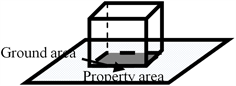
In fact, when one is able to process data comparing built-up areas and artificial/urbanized areas, it regularly emerges how the latter are greatly oversized in relation to the functional building envelopes of which they constitute ancillary appurtenances, and how the relationship index (coverage ratio) has progressively decreased over the decades. This is a parameter by which, since the postwar plans, the ratio of built-up areas to voids has been managed and is expressed as follows:
(1)
where:
Cr = Coverage ratio.
GA = Ground area.
PA= Property Area.
In order to give an effective response to the current international and EU matrix guidelines of limiting land take, and of desirable reversal of the phenomenon, a different control of this classic urban planning parameter expressed in the formula (1) must necessarily be called into play in operational planning tools, orienting it to support urban design in terms of soil saving. This should apply in all homogeneous zones dealt with in Italian planning ( de Biase & Losco, 2018 ; Caldarice, 2018 ), with a decisive revision of current models.
It should be recalled for the purpose that Italian urban plans are prepared on the basis of Ministerial Decree No. 1444 of April 2, 1968, transposed in a rather generalized form by the regional laws that have followed one another in the following 54 years until today. The normative text identifies 6 types of homogeneous zones defined as follows:
A) The parts of the territory affected by urban agglomerations that are of historical, artistic or of special environmental value, or by portions thereof, including the surrounding areas, which may be considered an integral part, due to such characteristics, of the agglomerations themselves;
B) The parts of the territory totally or partially built up, other than zones 1): areas in which the covered area of existing buildings is not less than 12.5% (one eighth) of the land area of the zone and in which the territorial density is greater than, 1.5 m3/m2 are considered partially built up;
C) The parts of the territory intended for new settlement complexes, which are undeveloped or in which the pre-existing building does not reach the area and density limits referred to in subparagraph B) above;
D) The parts of the territory intended for new settlements for industrial or assimilated facilities;
E) The parts of the territory intended for agricultural uses, excluding those in which—without prejudice to the agricultural character of the same—the subdivision of properties requires settlements to be considered as zones C);
F) The parts of the territory designated for equipment and facilities of general interest.
As can be seen from the list, the areas in which new construction and related urbanization works are most concentrated are B, C and D, and it is precisely on these that control of the Cr parameter should focus. This could be done by also involving other supporting documents of the plans such as regional guidelines, technical implementation standards and municipal building codes, but giving Cr a more focused purpose than the urban planning tradition has done. A stringent regulation of Cr will certainly be more complex in the case of areas intended for productive purposes (industrial, artisan, commercial...), as the required extent of outdoor space depends on the individual and very heterogeneous characteristics of businesses, but it can be operated much more effectively and uniformly in the case of residential uses. The present work attempts to set up a path of analysis and diagnosis, partly uchronic, that demonstrates the relevant appreciability of the results achievable by applying attentions directed to the full-empty balance of urban fabrics, deriving simulation outcomes from the current situation, but clearly projecting these outcomes into the planning of future arrangements.
The topic is part of a broad field of international interest centred on the recovery of urban compactness and the retrofit of sprawl, fuelled by a significant scientific production ( Burton, 2002 ; Tsai, 2005 ; Mubareka et al., 2011 ; Guastella & Pareglio, 2014 ).
2. Material and Methods
There are currently no national data available in Italy, homogeneous for the entire territory, describing the distribution of buildings and the population residing in them. As can be guessed, this is extremely detailed information which, when realised, will generate a package of bigdata that is not easy to process. Its availability is currently limited to very small territories and would therefore not allow the national situation to be described. For the present work, therefore, we have used data from different sources, although still produced by government agencies, applying, as explained below, compatibility procedures that can, albeit with a wide tolerance, provide the necessary information. The method used, firstly, had to produce an estimate of the Italian artificial/urbanized areas intended for residential purposes. The ISPRA survey ( Munafò, 2021 ) does not separately contain this functional characteristic, and therefore a selection of categories was made (dataset SC_LAEA_2020_v21 available on the ISPRA portal https://www.isprambiente.gov.it/it, accessed September 2022) extracting those most likely to be connoted by the presence of built-up bodies: 1 (consumed soil), 11 (permanent consumed soil), 111 (buildings, buildings, warehouses), 115 (harbors), 116 (other impermeable/paved areas). Secondly, the most up-to-date ISTAT data (2011) were analyzed, which report for Italy the size of total buildings and those used for residential purposes: the national values report about 14.5 million buildings in total, of which 12.2 million are identified as residential, thus expressing a fraction of 84 percent. The same fraction was applied to the urbanized areas derived from the overall ISPRA dataset as mentioned earlier, yielding 1.15 million hectares compared to the overall 1.37. From this it follows that the residential housing density (DAUR) on the areas designated for this is of the order of 52 inhab/ha compared to an overall national average density of 1.89 inhab/ha). These steps, while also incorporating the 2011 ISTAT census information of the resident population, made it possible to calculate some indicators as follows:
(2)
(3)
(4)
(5)
(6)
where:
HDB = Housing Density of Buildings.
HDURA = Housing Density of urbanized residential areas.
MRPA = Mean Residential Property Area.
RDGA = Residential density of ground area.
nrsin = Number of resident inhabitants ( ISTAT, 2011 ).
UAru = Urbanized area for residential use.
UAlt = Urbanized area derived from land take ISPRA data 2020 (categories 1, 11, 111, 115, 116).
nrsb = Number of residential buildings ( ISTAT, 2011 ).
ntb = Number of total buildings ( ISTAT, 2011 ).
All indicators were calculated on a provincial basis, classifiable according to the nomenclature of European Administrative Units EUROSTAT as NUTS 3 (https://ec.europa.eu/eurostat/web/nuts/background), and of the 7904 municipalities (https://www.istat.it/it/archivio/6789, (https://commons.wikimedia.org/wiki/Category:Municipalities_in_Italy).
3. Results
In the following section, the indicators listed above were calculated on the basis of Italian municipalities and provinces. The main focus was on the indicator representing the average land area committed for a residential building (MRPA), to which the phenomenon of land consumption is directly and primarily linked. The data was then analysed according to the number and size of municipalities, also highlighting regional differences. A diagram was then drawn of the relationship between the various indicators and different residential building types and, in the end, it was shown that, even with slight reductions in some of the indicators, significant savings of urbanised land can be achieved. Several indications can be extracted from Figure 1, which shows indicator values on a municipal basis. The configuration of the HDB rather sharply traces the geographies of weakness of the Alpine and Apennine inner areas well emphasizing the dynamics of residential abandonment with a significant degree of adherence to the elaborations related to the National Strategy for Inner Areas (SNAI,
![]()
Figure 1. Geographical distribution of HDB, RDGA and MRPA indicators on a municipal (1.1 top) and provincial NUTS 3 basis (1.2 bottom).
https://www.agenziacoesione.gov.it/strategia-nazionale-aree-interne/). This represents a 2013 national policy that aims to counter the marginalization and phenomena of demographic decline peculiar to the country’s inner areas ( Cotella & Brovarone, 2020 ; Rossitti et al., 2021 ) by identifying 72 selected areas with 1077 municipalities for approximately 2,072,718 inhabitants.
The project aims to address, through the adoption of an integrated approach geared to local promotion and development, the problems of fragile territories, distant from the main centers of supply of essential services and too often left to their own devices. These cover a total of 60% of the entire area of the national territory, 52% of the municipalities and 22% of the population, and on such places the National Strategy aims to intervene, investing in the promotion and protection of the wealth of the territory and local communities, enhancing their natural and cultural resources, creating new employment circuits and new opportunities.
In contrast, the RDGA survey shows extreme national uniformity with respect to the underutilization of urbanized land for residential purposes. A uniformity broken exclusively in the very few metropolitan areas and which sees the entire country characterized by a very low RDGA and systematically less than 80 inhab/ha of area designated for residential purposes with an almost total indifference to latitude and local morphology. This is a phenomenon that inevitably leads to the waste of large sections of land since, even if containing few inhabitants, the areas are still artificialized and effectively deprived of their ability to provide essential ecosystem services such as stormwater absorption and agricultural production.
This characteristic is also denounced by the geographic physiognomy of the MRPA index, which sees, in the majority of the country’s municipalities, each building endowed on average with a direct appurtenance area greater than 1000 m2, with important and extensive sections in which it exceeds 1500. It should be taken into account in this regard that, with the exception of metropolitan areas or related to major cities, these areas concern a very large part of single-family construction with a high rate of spatial dispersion (sprinkling) ( Romano et al., 2017, 2019a ; Saganeiti et al., 2021 ).
The reading of the same three indicators on a provincial basis in Figure 2 (Eurostat NUTS 3) geographically extremes the phenomena by highlighting some areas more affected by depopulation (HDB < 3 inhab/edif) in the Alpine area, in the central Apennines, Sardinia and Sicily, while confirming the essentially national character of the very low RDGA (<0.5 inhab/100m2). An accentuation of the north-south latitudinal effect, on the other hand, is very pronounced in the case of the MRPA index, which shows a strong propensity to oversize building accessory areas already in central, but especially northern Italy. In relation to the latter indicator, the diagram in Figure 2 then also shows the regional distribution with southern or smaller regions placed below the national MRPA average of just under 1000 m2, but up to over 1200 m2 for Emilia Romagna and Veneto,
![]()
Figure 2. MRPA indicator values in Italian regions.
which are notoriously highly exposed to the phenomena of extreme pulverization of residential settlement.
Considering the national average values of the indicators used, which are as follows:
HDB = 4.86 inhab/build.
HDURA =1.89 inhab/ha.
RDGA = 5 inhab/1000 m2.
MRPA = 943.15 m2.
Figure 3 shows some of the results that have emerged from the implementation of the indicators themselves: diagram 3.1. shows how almost three thousand Italian municipalities (more than 37% of the total) have a MRPA value greater than 1000 m2, while only a little more than a quarter are those with MRPA ≤ 600 m2. As seen from Figure 1, the essentially spontaneous occurrence of these classes with limited MRPA unites the western and central Alpine area, the northern Apennines, the central and Calabrian Apennines, and the more mountainous areas of the major islands. As soon as the landforms become more expansive, MRPA increases significantly and, along with it, soil artificialization. The significant underutilization of space and buildings in the country is also evidenced by the fact that, in about half of the Italian municipalities (Figure 2), there is an HDB value of less than 3 inhab/building (national average = 4.86). In the case of Figure 3, the numerical prevalence of municipalities with RDGA < 50 inhab/ha, which account for more than three-quarters of the entire national endowment of municipal authorities, is definitely impressive.
Figure 4 shows the effectiveness of the control that can be achieved on the RDGA indicator in planning rules by managing some critical parameters such as Cr, DAE, building volume sizes and private appurtenant space uses. The two indicators Cr and increasing RDGA are closely related to the increase in built
![]()
Figure 3. Classification by number of municipalities of MRPA, HDB and RDGA indicators.
![]()
Figure 4. A scheme of variation in RDGA, MRPA and Cr parameters at different configurations. In yellow, the configuration most similar to the national average.
volume, with the same amount of land area. The solutions that would achieve significant land savings without affecting built volume, the true vector of building economies, is the systematic provision of underground parking spaces in the same building footprint and/or the pooling of appurtenant areas for multiple buildings through finalized urban planning projects. From Scheme 1A to 5A in Figure 4, there is an increase in RDGA of more than 9 times against an increase in committed MRPA of 3.3 times. This example, however, is characterized by a marked change in building type (from single-family to intensive multifamily), but even remaining on the same single-family model, which is moreover very present in Italian residential demand, moving from Scheme 1A to 1B the RDGA doubles at the same MRPA and with a modest increase in Cr of 43%. Already a contraction of MRPA from the rather frequent 800 m2 to 500 m2 would result in over 37% land savings, which, over the extensive suburban areas of Italian sprinkling, could result in huge differences in the amount of vacant soils.
What has been mentioned, is more evident from the uchronic simulation carried out on the Italian settlement and returned in Figure 5. As the MRPA changes in reduction (Figure 5(a)) the land committed to urbanization is drastically and very quickly reduced, and in Figure 5(b) a sampled simulation is exhibited
![]() (a)
(a)![]() (b)
(b)
Figure 5. (a) Comparison of the trend in the estimated rate of reduction of land consumption for residential purposes with the areas of land saved as MRPA values decrease; (b) Squares represent land-saving areas compared to current extent with indication of change in MRPA index compared to the size of some of Italy’s largest urban areas. Below are the percentages of land savings.
that shows how, with a maximum contraction of the MRPA from the current over 940 m2 of national average to 600 m2 an amount of land equal to that covered by the urban areas of Turin, Bologna, Rome and Naples or slightly less than the extension of the entire Molise region would be saved. But even less incisive choices in the cutting of appurtenant surfaces would still lead to very appreciable results: already with 800 m2, there would be a saving of 23%, which becomes 28% with 750, 33% with 700 up to over 40% with the already mentioned option of 600 m2. In terms of surface area, in the condition just mentioned of MRPA = 600 m2, we are talking about almost 4200 km2 subtracted from urbanization that would have been available for the provision of important ecosystem services of supply and regulation, considering that in 90% of cases Italian urban areas are developed at the expense of low hilly and flat areas destined for agriculture and animal husbandry ( Dall’Olio, 2010 ; Romano et al., 2013 ).
The assessments derived from the uchronic survey provide a fairly clear indication of the technical directions for achieving greater urban compaction, which, beyond sectoral or movementist expressions, is currently in the midst of the cultural debate on the sustainability of the future of wide-ranging settlements: economic, performance, energy, social and environmental. One of the undoubtedly most interesting points in this regard is the “15-minute city” model ( Allam et al., 2021 ), which epitomizes many of the listed sustainability outcomes, but compaction is also included in the desired outcomes of urban regeneration, an action that should under no circumstances become an occasion for further land consumption, but for spatial contraction and reorganization ( Forgione, 2019 ).
While remaining in the sphere of decision-making hegemony of the Municipal Plan, which, as mentioned above, seems to be a political invariant of the country that does not find, at least for now, any readiness for re-discussion, the arguments posed manifest several sides of attack to enable the achievement of considerable results:
· compaction of land areas;
· control of coverage ratio (Cr);
· systematic placement of private parking spaces under the building basements;
· aggregation of volumes;
· application of coordinated urban design actions, including in B zones, to optimize the availability of for multiple buildings;
· reduction and geographic-spatial confinement of land areas designated for buildings.
These are all achievable goals by working on the content and structure of the Technical Implementation Standards and building regulations, as well as on the devices of agreement, participation and land equalization, already used in a consolidated form in the operational procedures of the plans ( Micelli, 2012 ; Camagni, 2014 ).
On the subject of “soil,” municipal urban planning tools often manifest inability/impossibility to grasp the most advanced conceptual, methodological, technological and cultural messages, as they are frequently very dated in their elaboration: in fact, almost 20% of the Italian territory and municipalities are managed with pre-1995 plans, with over 700 municipalities with tools dating before 1984 and over 300 pre-1977, with 2,500,000 citizens residing in over 1 million hectares (an average Italian region) regulated by plans updated between 1969 and 1977. It goes without saying that, such outdated tools, will not be adequate to accommodate and deal with instances such as those related to the reduction of land take, but also to the effective countering of multisource hazards, climate adaptation, the improvement/enhancement of ecosystem services, and the much more that the contemporary is presenting to collective attention ( INU, 2017 ; Romano et al., 2018 ). Nor can the albeit advanced and pervasive community guidance alone be sufficient.
This is to reiterate how in the country we continue to neglect strategic planning and urban design, which seem to be the only vehicles capable of pursuing results on what are shaping up as epochal challenges of land governance ( Munafò & Marinosci, 2018 ) and which inevitably involve concepts such as urban densification (infilling) and de-impermeabilization (de-sealing) ( Di Luca, 2011 ; Coppola, 2012 ; Perrone & Gorelli, 2012 ).
Urban compaction, especially considered as a goal to be achieved by working on existing settlements, undoubtedly involves considerable effort, which cannot be achieved through simplistic solutions ( Vergnes et al., 2014 ; Lin et al., 2015 ; Dembski et al., 2020 ), and the difficulties are amplified in a legislative context that has not been able to produce an update of the national urban planning framework in 80 years.
4. Conclusion
For the application of the actions of re-aggregation of the dispersed settlement in their various forms (sprawl, sprinkling, urban dust) one must take into account that urban fabrics, throughout Italy, are dotted with areas of precarious/dismissed use theoretically usable for new functions ( Filpa & Lenzi, 2013 ), but very often, these areas are privately owned and therefore the public operator is generally prevented from including them in the circuits of compensation, equalization and soil balance.
Some help in this regard, at least partial, could be sought in public-private negotiation procedures (program agreements and the like), but too often these result in only apparent conveniences for the public side, or at any rate too small in scope.
Therefore, there would be ample room for reform on this front as well, to decisively accentuate the conveniences of contracts toward the public, resorting to solutions of geographic relocation of concessions/compensations and broadening their area of action to the purchase of areas, natural redevelopment of degraded and abandoned surfaces, demolition of ruins and illegal buildings with subsequent de-impermeabilization, restoration of semi-natural landscapes, and recovery of agricultural spaces.
The connection of the topics outlined with the theme of “land take” seems very well evident, but equally there emerges a need for a wide-ranging reform of many national regulations, that have been left on stand-by for too long, by means of a vigorous and systemic reinterpretation that will produce, according to the principles of an unapologetic realism, an updated redesign of national land regulations that cannot be dispensed with any longer.