K. K. LWIN ET AL.383
smart phones are becoming more and more compact and
functional such as iPhone (Apple Inc.) and Android
(Google). Computer scientists at the University of Wa-
shington have used Android, the open-source mobile
operating system provided by Google, to turn a cell
phone into a versatile data collectio n d evice by collecting
deforested area and instantly submitting that information
to a global environmental database in a flexible manner
[2]. In the meantime, world cellular mobile phone sub-
scribers are increasing year by year. According to the
International Telecommunication Union ITU’s 2010 re-
port, by the end of 2009 there were an estimated 4.6 bil-
lion mobile cellular subscriptions, globally corresponding
to 67 per 100 inhabitants [3]. Recently, a couple of stud-
ies have demonstrated field data collection with mobile
phones in both the educati o nal and industry sectors [4,5].
On the other hand, the increasing popularity of the
Internet and user-friendly web-based GIS applications
such as the Google Maps/Earth and Microsoft Bing
Maps platform have made GIS an integral part of life
today, for finding the closet facilities, driving routes and
so on. For example in Tsukuba City, Japan, local resi-
dents and green exercise takers can search for the short-
est or greenest route between multistop trips through a
smart phone while walking down the street by accessing
the Eco-friendly Walk Score Calculator web-based GIS
[6]. However, PDAs, Netbooks and smartphones are
sometimes considered as costly, including both device
and wireless access service charges, not suitable to use in
student field survey project. Moreover, mobile field
computing environments vary widely, but generally offer
extremely limited computing resources, visual displays,
and bandwidths relative to the usual resources required
for distribut ed geo s pat i al data [7].
In this paper, we discuss the collection of field data by
a GPS embedded personal mobile phone and POP3 mail
service. We also construct a Web-based GIS system to
integrate, store, share and retrieve the collected data in
real-time, which could be used for example in metro-
logical data collection (i.e. surface temperature, wind
speed/direction) and damage information in disaster ar-
eas at various locations. The main objective of this de-
velopment is to collect the field data in a timely, handy
and cost effective manner.
2. Web-Based GIS System and Real-Time
Field Data Collection
2.1. How It Works
We have developed a personal field data collection soft-
ware called Ultra Mobile Field GIS (UM-FieldGIS) for
the UMPC or Netbook computer, to collect field data
using either Google Maps or a pre-installed map (PIM)
[8]. UM-FieldGIS allows users to create, edit and modify
the survey items and attach multimedia information.
However, UMPC or Netbook computers and Wi-Fi In-
ternet access services are expensive and not suitable for
students. We need to fi n d an alternate way to collect field
data in a handy and timely manner at low cost, such as
using a personal mobile phone.
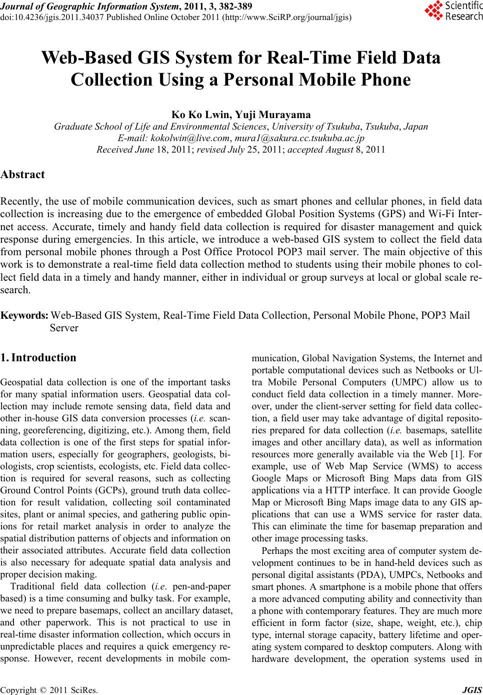
Figure 1 shows the detailed system design of field
data collection using a personal mobile phone. Basically
this system can be divided into three sections; named
Field Data Collection, Automation Process and End Us-
ers. Field Data Collection includes a GPS embedded
mobile phone or GPS plus mobile phone. All functions
of receiving mails, data injection and format conversion
processes will be performed automatically, called the
Automation Process. Finally the End Users Section in-
terfaces with the Web-GIS for survey data downloading,
GIS data visualization and performing spatial analysis
functions through a web-GIS browser at low cost, such
as by using a personal mobile phone.
Field Data Collection: We utilized a GPS embedded
mobile phone which typically supports additional ser-
vices such as Short Messaging Service (SMS), Multi
Messaging Service (MMS), e-mail and Internet access;
short-range wireless (infrared or Bluetooth) communica-
tions; as well as business and gaming applications, and
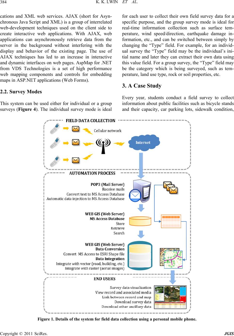
photography. Users are required to type predefined text
format for collecting the data. For example, the user
needs to add the “/” character between fields and add “,”
between attribute values (Figure 2). This text message
will be sent to a predefined mail address with a prede-
fined subject. The user can also attach photos, as many
as required.
Automation Process: This text message is read by a
POP3 mail server and then converted into Microsoft Ac-
cess Database format. Under the Web-GIS system, this
MS Access Database is converted into an ESRI Shape
file and integrated with another GIS dataset, such as
roads, building footprints, aerial images, etc.
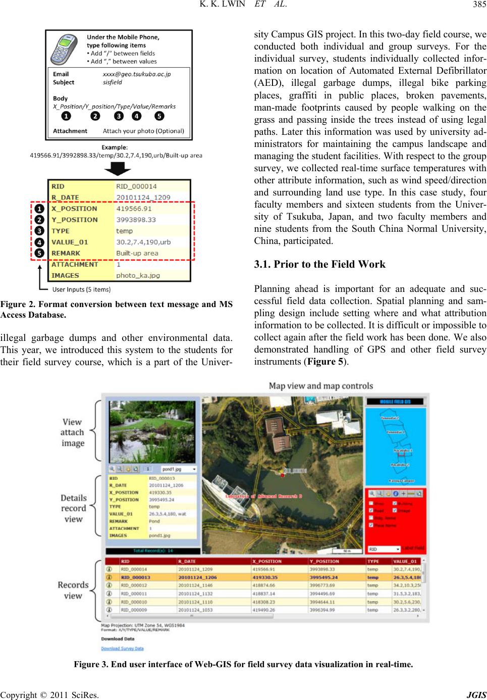
End Users: Users can download up-to-date survey data
in an ESRI Shape file format through their Web-GIS
browser. User can also perform basic GIS functions such
as distance measurement, finding the closet facilities
within user defined search distances, labeling of attribute
names, linking between survey records and maps, and
viewing the attached image files through a Web-GIS
browser (Figure 3).
The overall system is built on Microsoft ASP.NET
with an AJAX Extension and VDS Technologies (Web
Mapping Components for ASP.NET). ASP.NET is a web
application framework marketed by Microsoft that pro-
grammers can use to build dynamic websites, web appli-
Copyright © 2011 SciRes. JGIS