1. Introduction
Forests in the Republic of Serbia occupy 2.252.400 ha, in percentages expressed 29% of the total area of the Republic. In the past, the woods of Serbia were between 35% - 40%.
State-owned is 53% of the total forest area, or 1.194.000 ha, or 61.1% of the volume: timber. Private forests occupy 1.058.400 ha, or 47% and have a smaller volume of 38.9% of the volume: wood mass ( National Forest Inventory, 2012 ).
There are 10 types of oak in the forest fund of the Republic of Serbia: Quercus robur L., Q. pedunculiflora Koch., Q. petrea (Matt.) Liebl., Q. dalechampii Te., Q. polycarpa Schur., Q. farnetto Ten., Q. pubescens Willd., Q. virgiliana Ten., Q. cerris L., Q. trojan Webb., which in the forestry fund of the Republic of Serbia occupy 720.800 ha, that is, 32% of the area, of which 276.000 ha are state-owned, and 444.000 ha are in private ownership. The percentage of oak forests occupies 23.2% while in private ownership it occupies 41.9% ( National Forest Inventory, 2012 ).
As far as the oaks themselves are state-owned, the highest share is 9.7%, followed by a hybrid with 7.5%, sugar 3.6%, gluten with 2.7%, and a brass with 0.9% (same source).
Since this paper deals with the sandwich, it should be noted that the forests of sandblast (from state forests) in the Republic of Serbia cover 32,238 ha (2.7%). This is a solid percentage and significant area under the alkaline forests in the Republic of Serbia, which represents a great ecological and economic potential and therefore should be paid attention and adequate treatment.
![]() 1Taken from the Google map-area of research.
1Taken from the Google map-area of research.
Figure 1. (Study area). 3 colored fields are displayed in red color1.The borders between the test fields are also marked in red.
2. Methodology of Work
Šumadija is the central region of the Republic of Serbia and occupies an area of 5796 km2. It covers the area between: the Sava and the Danube in the north, the Great Moravans in the east, the West Moravans in the south, and Kolubara in the west. Surface under forests in Šumadija with which J.P. Srbijašume is 25.438 ha (http://www.srbijasume.rs/), represents huge potential, both in ecological and in every other sense. Forestry farm “Kragujevac” grows over these forests.
The research will be carried out at the gas unit “Rogot”, which has an area of close to 500 ha (Forest Economy Base 2008). Of this 440 hectares is under the oak tree (Quercus robur Lat.). The other 60 hectares are other forest cultures. It is important to note that oak forests in this area are 75 - 80 years old.
In Figure 1, shows the field of view as well as their boundaries. Experimental fields of view are separated according to the prescribed methodology used in forestry. The field of the field is 25 acres (50 m × 50 m) ( Banković , 1995). Further detailed analyzes of climate factors were made, with particular emphasis on precipitation and temperature. In addition to the high representation
In addition to the high representation and importance of forestry and forestry in general, forests in the central Serbia-Sumadija region have been very little explored in terms of the impact of climate and climate impacts, which gives space and opportunities for research and analysis, and in particular provides a broader basis for dendroclimatological analysis, This area is predominantly with uniform relief and with pronounced hydrological characteristics, which is of great importance for dendroclimatic research.
Climate studies:
Concerning air study of the area, it is quite continental to moderately continental. Climatic conditions differ depending on the altitude, relief and exposure with the average annual temperature is 11.8˚C, the period without frost of between 180 - 215 days and the period of sunshine of 2100 hours per year. The maximum and minimum temperatures ranged in their absolute amount of 41.7˚C - (−37˚C). It can be concluded that there are large fluctuations in temperature, where the hottest months are July and August, and the coldest January and February.
Furthermore, average annual rainfall is 681.8 mm, and since the winds are the most northern squally wind. The snow and wind have negative effects and fractures in cultures are noticeable as it is well known that black pine has deep roots and resistant to rippings by the wind, which is not the case with heavy snowfalls and strong winds.
In order to study floristic composition and phytosociological determination of belonging study stands, phytocoenologically captured at all sample plots obtained by the method of Braun-Blanquet’s.
In all experimental fields is done the following: entire dendrometric diameter measured, diameter, height, drill punched the tree, for taking increment cores and computation of gain, by Presler method. On the basis of the data, the volume and growth were calculated and measurements and analysis of growth rings were performed in the laboratory, by special instruments and related software (Digital position metre, TSAP, statistical analysis, etc.).
Observing the action of both endogenous and exogenous factors was conducted, supporting on the state of the stand and directly, based on quantitative and qualitative characteristics of volume increment. Monitoring the situation stands, covers, mostly components that are related to stand structure and which, together with the analysis increments allow for a realistic assessment of the current situation and future forecast development.
Hydrological factors as essential factors of research:
The investigated area of G.J. Rogot once turned to Velika Morava (small part) and, in most part, turned towards Lepenica. The third and least part of this gaz unit is not affected by any rivers, creeks, etc.
Oak forests are in the aforementioned rubber unit “Rogot”, about the same age: 80 years. This is quite enough for the age of the tree, for dendroclimate analysis, to make the research valid. In the investigated area, oak forests will be analyzed through field experiments, depending on the hydrological impact (the influence of the river, the stream). Hydrological influence is what they differ, given the position of the field. They are also distinguished by their solitude. A clear correlation between hydrological impact and dendrological characteristics of oak is obtained.
Note: Since in Figure 1, the marked limits of the experimental fields, in Figure 2, there was no need to mark the same. Figure 2 shows the hydrological position of the river and the stream, and this is emphasized here.
Figure 2. Hydrological map of the investigated area, G.J. ROGOT-red color marked experimental fields. Blue arrows: rivers and streams. Blue arrows mark the rivers and streams in the exploratory area.
Lepenica is the largest and most important river of the investigated area. It springs near Gledić Mountains in the village Goločelu, and flows into Velika Morava as a left tributary. It flows from its source from the south-west towards the north-east through the Kraagujevac basin. Lepenica’s length is 49 km. Earlier length was 60 km. and it ran parallel with Morava. However, since the great flood in 1987, it has been regulated and now flows in the direction of the northeast. Lepenica yields close to 4.5 m3 of water to the Great Moray. However, in the case of large droughts, as in 2017, this quantity is falling to 2 m3. Lepenica runs 40 liters per second. We need to mention the local river: on the explored area: Dobrovidačka river, then: Cvetojevski potok, Botunjski potok, and others.
3. Results
The elements of stand structure of Oak-forests in research area, (Figure 3, Figure 4, and 5-diameter, volume, height, structure) crown development, biological position of the trees), and in particular the volume and diameter structure, showing that the stand is in a phase of strong regressive succession (Cedro, 2004). Oak, as species, has a relatively strong impact if included the land, the ground flora, microclimate, vegetation, stand aging and site conditions (Barčić et al., 2010). Oak is known as a species that can regenerate its growing force, regardless a greatly suffering and damage that can suffer, so in case of favorable conditions, it can be manifested in diameter and volume increment a lot, (Figure 3, diameter incremenet) of 5 trees with the highest increase. This stand is dominated by species of lower production, namely lower ecological.
![]()
Figure 3. Currently diameter increment for 3 experimental field.
In Figure 3, it is shown the growth of trees in thickness, shown is actually the currently diameter increment for five analyzed trees, for all three experimental fields, growth curves, show actually known flow, growth and development of trees in thickness, and there are no major discrepancies. If you take a closer look at the graph, we see that in II tree analysis, i.e. in another experimental field, that values a little higher in the second relationship to the tree analysis, the reason is because they are in the experimental field made care measures, thinning, about 30-year of age. All other curves are more or less similar to the flow. First culmination of gain was between the 10 and 20 years of age. Growth curves would have a different course that made care measures in another experimental field, that values a little higher.
For 1. Experimental field current diameter increment is 1.1 cm.
For 2. Experimental field current diameter increment is 1.6 cm.
For 3. Experimental field current diameter increment is 0.9 cm.
![]()
Figure 4. Currently volume increment for 3 experimental fields.
In Figure 4, it shows the current volume increment for all three field fields. It seems that the increase began to grow after 30 and after 40 years, which is also logical, because the oak only later gives its maximum increase.
For 1. Experimental field current volume increment is 0.012 m3/ha
For 2. Experimental field current volume increment is 0.018 m3/ha
For 3. Experimental field current volume increment is 0.02 m3/ha
![]()
Figure 5. Showing the flows of currently height increment for all five analyzed trees.
The instantly recognizable culture differences between younger 1 and 5 experimental field, the height increment culminated between 10 - 15 years of age. There is an obvious influence of habitat and land, which are better habitat before coming to the culmination of all increments and even height. This is important for black pine, because it rarely gives better results in better soils. The impact of the land is best seen by comparing the field 3 and 4, where they both culminated about 10 - 15 years of age in his youth, and the other is in the culmination at the third experimental field with about 3o year of age while at the fourth experimental field it is even after 40 years of age. In Figure 5, it is shown the flows of currently height increment for all five analyzed trees.
For 1. Experimental field current height increment is 0.5 m
For 2. Experimental field current height increment is 0.4 m
For 3. Experimental field current height increment is 0.65 m
![]()
Figure 6. The tree is shown where the first field of view starts.
![]()
Figure 7. The tree is shown where the second field of view starts.
![]()
Figure 8. The tree is shown where the third field of view starts.
Figures 6-8 show the experimental fields, or more precisely, the start of the experimental fields, where the investigations, measurements, and all dendraclimate investigations.
![]() .-dentisty of wood, .- percipitation, .-temperature
.-dentisty of wood, .- percipitation, .-temperature
Figure 9. X-axe: time, years; Y-axe: density of wood (values).
Figure 9 shows how the density of the oak tree varies depending on the climate parameters. Blue shows the precipitation, and the red temperature. All temperature and precipitation values were taken from the state meteorological institute (RHMZ, Republic Hydrometeorological Institute, 2016). If we carefully look at the graph, we can always see the small culmination of precipitation, then increase the density of the tree, not much, but noticeably, and thus we have proven that the oak reacts to climate change. It should be noted that the patterns of the trees are from all three fields. On the Y axis are the values of tree density, X axis is the age of trees, on the vertical axes the right are the rainfall blue and the temperature is red... Clearly, the density of wood changes depending on the climate factors. All the tests were done in laboratory conditions at the Institute of Climatology in Kragujevac.
Figure 10.  Width of Tree RINGS (mm);
  Percipitation per year (mm);
  Temperature C.
In Figure 10 show, Similarity between tree ring width chronology of the Oak tree (Quercus robur Lat.) blue color indicates precipitation, green beam temperature. The red color indicates the width of the trees rings. It is noticeable if the graphic is carefully looked at, that at a slight culmination of precipitation, it grows in size and width of the years. from this it is clearly seen the climate impact on oak forests in the investigated area.
Dendrochronology of and the character of Oak tree (Quercus robur Lat.). Its reactions to exogenous factors are checked by volume and the radial increment, i.e. the width of the growth ring. (In addition to the width of tree rings as a significant production indicators, the analysis of variation in the width of tree rings from wide to very narrow is of particular importance, as bio-indicators of vulnerability of a species in a given habitat (Fritts, 1974). In addition to the oscillation, the width of tree rings is very important indicator of the trend of growth.
4. Statistical Indicators
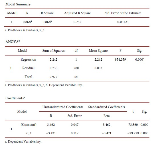
Analysis of variance of the first experimental field: Experimental field 1:
Analysis of variance of the second experimental field: Experimental field 2:
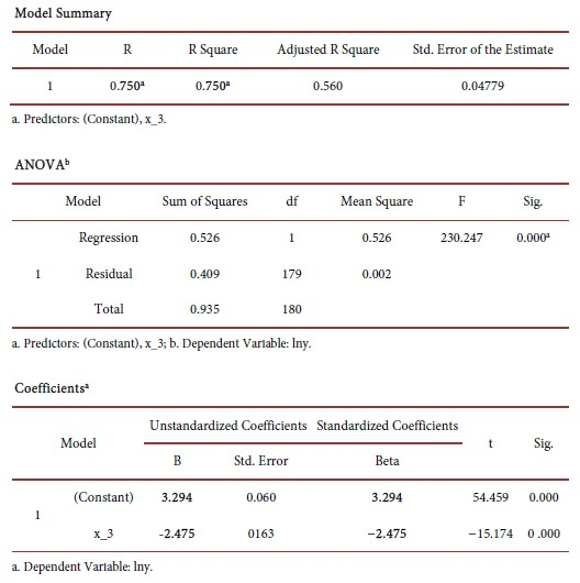
lna = A = 3.294, b = −2.475
a = 26.95
The equation of the curve of growth: formula as Graph 2.

Analysis of variance of the second experimental field: Experimental field 3:
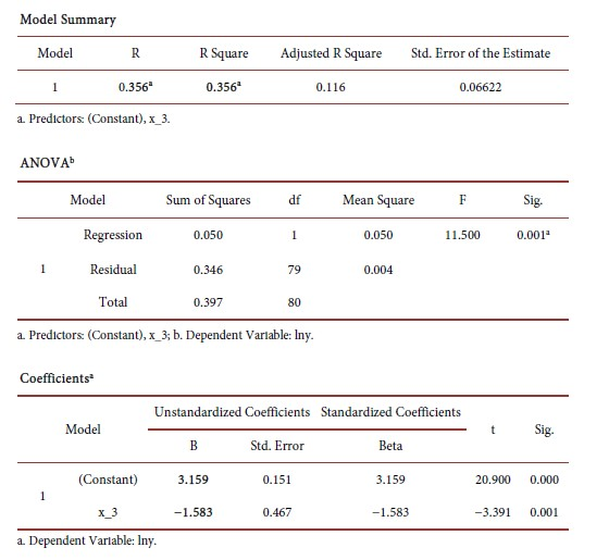
lna = A = 3.159, b = −1.583
a = 23.55
The equation of the curve of growth: formula as Graph 3.

NOTE: All statistical data, coefficients, models were obtained through the official statistical program SPSS 21, which is used in the calculation of statistical data in scientific works. SPSS is the official program that is being used.
Important:
In order to arrive at the final results, we used computer programs for the processing of climatological data (presented in the previous chapter through the graphs).
Computer programs are based on IPCC climate models, and programs are from the software package from the web site: KNMI Climate Explorer, like COFECHA programs, and ARSTAN. These programs -climate models (according to which the desired results obtained in this paper are also presented) represent the basic tool for dynamic scaling of the results of global climate models and assessment of future climate change caused by the increase in the concentration of greenhouse gases in the earth’s atmosphere (Cook & Pederson, 2010). It is the basic method for analyzing climate change in a specific research area. The results of climate models have been verified so far and have therefore enhanced confidence in this approach. Regular IPCC reports are based on the results of these models (Griffin, 2014). The associated regional climate model EBU-POM, which was used, was created by linking the regional model, the atmosphere and the ocean (St. George et al., 2014). The acronym of this model is derived from the name of the component EBU (Eta Belgrade University) and POM (Princeton Ocean Model). The reason for including the ocean component in the system is due to the fact that for long periods of time such as climatic, atmospheric and ocean interactions have to play a decisive role in defining the state of both components individually (Woodhouse, 2001).
For all climate models that are useful for obtaining desired results, it is necessary, above all, to “register users and log in” to access the system, except for access to climate data (when entering latitude and longitude data) they allow us to correlate and regression analysis, calculate possible extrema, and many other climate information that are necessary for dendrokylmatological research. The above programs, all the data we make available to them freely, are processed and a single essence (extract) is displayed, which is graphically displayed. As we got it for the first, we got both the second and third field of view. The results and statistical data processing will be displayed through items.
5. Conclusion
Unlike black pine (Pinus nigra Lat.), in the same area whose dendroclimatological research worked (Šikanja, 2017), the species was less sensitive to climate change than oak.
On the basis of all the above data, charts, histograms, tables, in the end, based on all the obtained results of the survey, based on the monitoring of the most important climate parameters (precipitation and temperature), based on taking all the important orographic, hydrological factors, on the basis of the tree trunks, on the basis of drilling 30 trees, by the presler drill (the generative tree and the tree of deciduous origin), in all experimental fields, further based on the monitoring of the density of late wood, one can conclude the followings:
1) The oak forests of the Quercus robur Lat. in the investigated area may be a reliable indicator of climate change, and through woods of trees, it can be read-in effects of climate change.
2) Thick-field studies are the basis of dendroclimatology and dendrochronology.
3) Specifically, these studies, in the forests of the litter, have character pioneering and are based on scientific principles, which are applied in the world.
4) Specifically, oak ore can be characterized as a kind of wood, which is sensitive (sensitive) to climatic influences.
5) A solid data base (climatic, dendroclimatic, forestry) was obtained for the part of Sumadija, which can be a good basis for subsequent research in this area.
6) Hydrological impact in the explored area is very pronounced as the local area runs through the explored area by local rivers, streams, tributaries, etc.
7) Considering the fact that during the survey, the relief (inclination, exposure), and the origin of the trees (deciduous and generative), further analyzed the density of the late tree, and that all ecological factors (biotic and abiotic) were taken, in view of this, we can be sure of the reliability of the results obtained.
8) All relevant data related to meteorological and climatic research were obtained from RHMZ, and through their official web address: http://www.hidmet.gov.rs/, which also supports the reliability and credibility of the results.
9) When creating specific diagrams-charts, we use climate models that can be obtained over the web: IPCC and KNMI Climate Explorer pages, for which the use of user registration is required first of all.
10) On the basis of everything set out, we can be sure that the works are valid-pioneering dendroclimatic research in the investigated area of G.J. Rogot.
NOTES
*Dendroclimatology is a new scientific discipline in the world. There are few papers in the Republic of Serbia in this field. After many years of research, here is one original scientific paper from the field.