The Accuracy Analysis of Measurement Tools for Traffic Accident Investigation ()
Keywords:Traffic Accident; Measurement Tools; Data Accuracy
1. Introduction
The number of road traffic accidents is constantly on the rise, which can be attributed to the increasing number of vehicles and drivers and to a higher standard of living. Such increase in the number of traffic accidents creates additional workload for law enforcement personnel, since they have to process more traffic accident scenes, which can cause time constraints for data collection at individual accident sites, resulting in less accurate data.
Collecting data at traffic accident scenes, especially data related to gathering evidence and performing measurements for processing the scene, can lead to certain factors, which affect other traffic participants. According to certain studies, closing down a main road can cause costs of up to €140,000 per hour of closure. In addition, closing down a road also affects other traffic participants, since drivers are usually frustrated when they have to wait for a traffic accident site to be cleared. Therefore, the shutdown period of the road due to a traffic accident must be kept as short as possible.
Data collection methods, measurement tools and the quality of collected data, depending on the measurement tool that is used, are crucial for making a quality drawing of the scene. However, collecting quality data from an accident scene requires a certain amount of time. Since investigators strive to shorten the time required for performing measurements at the accident site, this can unintentionally negatively affect the accuracy of the collected data, which can in turn significantly influence the verdict in case of a serious traffic accident. Reduced measurement accuracy can therefore lead to an unjust conviction or acquittal of a traffic accident participant.
Data collection speed and accuracy depend on which methods and tools were used. Different countries use different methods and measurement tools for traffic accident investigation. These tools can range from classic methods like adhesive tape ruler to tachymeters, complex total stations, GPS, photogrammetry [1] and all the way to modern laser scanners.
The most common investigation activities used for documenting traffic accident scenes include: photography, collecting video data and scene measurements, followed by a detailed drawing of the scene [2].
The most commonly used method for collecting spatial data is the 2D method, where measurements are carried out along and offset from the road edge or centreline. Total stations and laser rangefinders are also commonly used tools; GPS has been successfully used as well, however, only in areas where there were no obstructions. Recent developments include close-range digital photogrammetric systems [3,4] which provide fast and accurate data acquisition but can be relatively expensive and complex to use for local police and traffic agencies.
Introducing the terrestrial laser scanning method enabled 3D documentation of the accident site in a much safer manner, since data were collected from a remote location, which enabled uninterrupted work of other units at the scene. This method of data acquisition is much more flexible, faster and can be used both in total darkness and direct sunlight.
In practice, police departments use different types of measuring equipment; how frequently each of them is used was researched by Walton et al. [2], whose study found that in Kentucky 60% of measurements were done with tape measures/measuring wheels, 24% with total stations, 13% with lasers and 3% with other tools. The same study also examined which methods of reconstruction were used by responding state police agencies at the US national level, arriving at the following conclusion: tape measure—39%, laser—12.5%, photogrammetry— 12.5% and total stations—36%.
The most commonly used data collection tool for accident scene investigation and for making a drawing of the accident is the tape measure or the measuring wheel, which represents the coordinate method of measuring the axes of the coordinate system, a triangular or polar coordinate system. This is the basic method that is still the most often used despite modern techniques and technologies that are now available. This method involves using a tape measure or measuring wheel to document the crash scene; however, electronic distance meters or laser instruments can also be used.
Accurate, quality and comprehensive traffic accident reports are crucial for entering data into data banks and for performing spatial analyses. Recently, Khan et al. [5] reviewed the traffic accident report forms that were used by the police departments in different districts and found that these forms can contain up to 99 different pieces of information pertaining to the accident scene. However, the accuracy and quality of these data did not reach a satisfactory level.
Considering the technological progress made until today, modern measurement tools should be used and not ignored. Modern systems guarantee timely, fast, accurate, integrated, accessible, standardized and uniform data. Also, the measurement process should disrupt the traffic as little as possible and provide end products that are easily transformed into 2D drawings [6].
However, with the enhanced scrutiny of any evidence in a court, and the need for the accident reconstruction data collection process to be as least disruptive to traffic as possible, the requirement has arisen for more comprehensive and accurate data to be recorded in the shortest time possible [7].
2. Material and Methods
The study is based on tests of research equipment and on a review of the relevant literature.
Case Report
The case report of this study contains a field simulation of a traffic accident, which allowed us to investigate the accident scene and carry out the required measurements. A statistic analysis of investigating the simulated traffic accident scene represents the second phase of studying a more serious traffic accident and also includes field measurements of where the participants, vehicles and traces were located. These measurements were carried out using three different methods: the coordinate method (measurements carried out by two police officers), with an electronic tachymeter or a robotic total station with an Imaging Station photo camera (measurements performed by two persons) and with the use of GPS—Hiper Pro receiver (measurements carried out by one person).
First, measurements using the coordinate method were carried out by two traffic investigators. They carried out on-site measurements using a measuring tape and made a croquis drawing. They used the classic rectangular measurement method, which is the standard method employed by the Slovene police for all measurements when a drawing has to be done on site. The method itself is reliable enough if the investigators are meticulous and perform the measurements according to instructions. Of course, measurement accuracy also depends on terrain configuration and road infrastructure. Particularly the latter is often not taken into account, which can lead to a gap between the “recorded” situation and the actual situation on site. At the police station, a qualified or skilled draughtsman redrew the croquis drawing as a handdrawn precise drawing according to the technical drawing rules. The data collection time was not recorded separately, which is in this case justified due to the gradual acquisition of data with all the required measuring tools.
Then, measurements using the electronic tachymeter Topcon Imaging Station (IS) were carried out by two persons (in this case they did not use the Remote Control System 3 (RC-3), which enables remote IS control). First, they carried out laser measurements of the same objects that were measured with a measuring tape in the previous example. Data was collected in the form of dots and lines. This enables a complete visualisation and a 3D model of the scene. The data collected on site was then imported into the ACAD environment, where it was compared to the results of other measuring equipment that was used in the experiment.
Finally, measurements with the Topcon GPS+ Hiper Pro receiver were carried out by a single operator, who measured the same objects that were previously measured with IS and the measuring tape. The collected data was spatially located and includes point and line data. The measured data was subsequently imported into the ACAD environment and compared to the others.
All the measurements and data processing was done based on regulations for on-site data acquisition in accordance with the Act of Rules in Road Transport (OG RS nr. 109/2010), which specifies that police officers must arrive at a category II, III or IV traffic accident scene, ... and process the scene or arrive at a category I traffic accident scene and gather the facts and evidence. When using the measuring tape a croquis drawing was done at the scene; when IS and Hiper Pro methods were used, only the measurements and the preliminary orientation were carried out. In case of the measuring tape method, terrain measurements were followed by making a precise drawing of the scene, which was done by hand by a qualified or skilled draughtsman of the police station. When using IS and Hiper Pro tools, no additional tasks were performed.
In order to compare the accuracy of gathered data we used the ACAD software, which enabled us to compare all three sets of data at the same time. Importing the precise drawing (.img file) and adding data layers (dots and lines) acquired with IS and Hiper Pro into the ACAD environment and their spatial allocation provided us with information on the general accuracy of gathered data. Overlapping the data in the ACAD software was done with the help of spatial allocation of data acquired with the IS and Hiper Pro methods and with a scan of the precise drawing, which was aligned based on the road axis. The final result is shown in the picture (Figure 1).
The picture (Figure 1) shows that measurements done with the coordinate method do not overlap with the measurements performed with IS and Hiper Pro. The overlapping of all three measurement methods was based on the basic premise that overlapping was best done based on the road axis or from the viewpoint of adapting the driving surface. The reason for this premise is the location of the vehicles in regard to the carriageway (in order to eliminate the possibility that one driver was driving on the wrong lane).
Based on test measurements and on the precise drawing (Figure 1) we found that individual measurements performed with IS and Hiper Pro almost completely match or that there is a maximum disparity of two points in the 2D models, of up to 10 cm in size. In most measurements the errors are insignificant. The reason for the above mentioned disparity in measurements can also be

Figure 1. A comparison of the three measurements methods: the coordinate method, Imaging Station and GPS+ Hiper Pro receiver.
attributed to the fact that IS and Hiper Pro measurements were done by two different persons and to the fact that the location of individual points was not pinpointed down to the exact centimetre.
However, if we compare the measurements done with IS and Hiper Pro to the ones done using the coordinate method and the precise drawing based on it, we find that there are much larger errors i.e. discrepancies between them. Based on the second picture (Figure 2) we can see that for example, the location of the VW car is not accurately placed. The rectangle shown in the picture represents the position of the vehicle’s wheels and it is almost impossible to align the measurements done using the coordinate method with those done using the IS or Hiper Pro. Here, we can spot an error in IS and measuring tape measurements, in the position of individual wheels, which varies from 0.4 m to 1.5 m.
Although these errors in measurement are based on single test measurements, significant discrepancies are noticeable in the measurement of individual points.
3. Literature Overview
An analysis of the existing literature on traffic safety and particularly on traffic accidents, measurement tools and data accuracy was based on a review of published scholarly journals, including peer-reviewed studies. Other studies were identified using IEEXplore, Proquest and ScienceDirect.
A review of the existing literature revealed a fragmentation and vagueness of research pertaining to measuring equipment for on-site data collection and underpinned the premise of the inaccuracy of certain measuring tools and methods. Our findings on the reviewed literature of the studied field are summarized below (Table 1).
4. Results
The literature review led to an analysis of existing measuring tools and methods and to defining the advantages and disadvantages of each one. Studies on the use of measuring tools and their accuracy are actually quite rare, neglected and too vaguely defined. The objective of this study was the accuracy of collected data, which significantly affects the justice of the verdict for traffic accident participants. The reviewed studies contain individual pieces of information on advantages and disadvantages of the measurement tools and the methods used in those studies; however, there is a lack of substantiation for individual statements in regard to their accuracy.
Measurements of our experimental collision scene revealed that there are mistakes or gaps in the accuracy of carried out measurements, as we had presumed there would be. The primary objective of the study was to analyse the accuracy of collected data in regard to the

Figure 2. A detailed look at the measurement errors pertaining to VW Passat’s wheel locations.
measuring tool or the method used and not to assess the remaining advantages and disadvantages of individual tools or methods. That is why the table (Table 1) does not contain all the advantages and disadvantages of the tested equipment, but only those that are not directly connected with additional observations like e.g. measuring the time required to collect individual pieces of data or all of them together.
The ACAD analysis of point and line data confirmed our own assumptions and the results of the studies by other authors. When performing test measurements we found it difficult to insert the precise drawing, which is based on data acquired with a measurement tape, into the ACAD environment and even more difficult to align it with the results of measurements done with IS and Hiper Pro, and to look for common points. The results of test measurements and the subsequent overlapping of individual elements therefore reveal an inaccuracy of data collected with a measuring tape and a comparable accuracy of measurements done with IS and Hiper Pro.
5. Conclusions
Different tools and methods for reconstruction of traffic accidents have different advantages and disadvantages. The latter can be categorized by depending on the price, portability, range, how their functionality depends on light and weather conditions, whether and to what extent the road has to be closed in order to perform measurements at the accident site or whether it is possible to carry out remote measurements, the time required to capture all data, the number of investigators required, the option of digitizing and visualising the collected data, the extent of follow-up work at the office (data processing) and particularly on the accuracy of the collected data.
The need to capture all relevant information is constrained by time pressures, and investigators typically revisit a crime scene between 8 and 12 times [11].
As a part of this study, we wanted to examine the existing tools and methods, analyse their advantages and disadvantages and test the accuracy of the data they pro
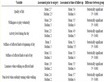
Table 1. A summary of studies pertaining to methodology and measuring equipment used in investigation of traffic accident scenes.
vide. Data accuracy can actually have a significant impact on the aforementioned justice of court. This of course refers to the elements, such as the precise microlocation of the event, location of traces, breaking distance, etc. which, combined with inaccurate measurements, can lead to errors in calculation of vehicle speeds prior to the crash and in errors in determining the microlocation of the crash, which is one of the primary objectives of traffic accident site reconstructions, since they serve as a basis for assessing drivers’ behaviour and since the court’s decision is based on whether the driver in the accident is proven guilty or not [12].
The total station with photo camera Imaging Station allows measurements with an accuracy of ±(2 mm + 2 ppm x D) m.s.e. when using a prism and ±5 mm m.s.e. up to 250 m when not using one; for measurements up to 2000 m, it is slightly less accurate with ±(10 mm + 10 ppm x D*) m.s.e. However, the reduced accuracy when working without a prism is offset by the fact that only one person is required for the task. Using the additional equipment Remote Control System 3 (RC-3) enables operation by only one person, and the measurement accuracy becomes equal to that of measurements with a prism. Compared to data acquired from literature and from reviewing the characteristics of the equipment, we can attribute similar accuracy to laser scanners, total stations, laser rangefinder systems and precise GPS systems. The GPS system Hiper Pro used in our case study features an integration of GNSS, radio, battery, Bluetooth and GNSS antenna into a single unit, which reduces the time required to finish the task. A further advantage of the Hiper Pro System is its accuracy down to a millimetre and the ability to perform point and line measurements while requiring only a single person.
Another interesting field that is related to data accuracy is photogrammetry. The accuracy of data acquired through photogrammetry depends on a number of factors like camera resolution, camera calibration method, angles between photos, photo orientation quality, photo redundancy and the use of targets. Furthermore, data processing software also affects data accuracy.
Results of the study by Randles et al. [13] show that measuring tape and photogrammetry are efficient methods for measuring vehicle points with a mean difference between the baseline and hands-on measurements of 0.6 ± 1.4 cm, and a mean difference between the baseline and photogrammetry measurements of 0.1 ± 1.0 cm. The accuracy of the photogrammetry method was found to be slightly greater than that for hands-on physical measurements.
The classic measurement method using a measuring tape, which is still the most commonly used method in the field, also has its advantages and disadvantages. Its advantages are its low price and the fact that it requires no additional equipment and no additional investigator training; however, its downsides are less accurate data, longer data collection and a more difficult subsequent data processing, which are all factors that affect the usefulness of this measuring method. But despite all that, we cannot ignore this time-proven method and the positive experience associated with it.
The tools and methods for collecting data at traffic accident scenes are well-known among the scientists and experts, and several studies have already been carried out in this field. In additions, researchers have found that other existing technologies (like GPS, which is mostly used by surveyors and in recent years for route planning in vehicles) can also be applied to this field and used for traffic accident investigation. However, we must not ignore the relationship between science and justice, which are in this case tightly intertwined, and ensure just verdicts regarding the guilt or innocence of participants in road traffic accidents.
Further studies in this field must therefore focus on additional test measurements with various tools and methods, and use of mathematical tools to ascertain the likelihood and the extent of possible mistakes.