Subsidence associated with land use changes in urban aquifers with intensive extraction ()
1. INTRODUCTION
Land use changes resulting from the interaction between people and their environment have become one of the primary factors responsible for altering natural processes and cycles. Land use changes due to urbanization has caused deforestation, soil erosion and a loss of biodiversity and environmental services, and has had a high impact on the degradation and depletion of water resources [1].
Since the 18th century, but more intensely over the past 50 years, humans have changed the world’s ecosystems more quickly and extensively than any comparable period in history. It is now recognized that even if land use changes occur locally, they may have global effects on the hydrogeological cycle since, as it has been shown, the quantity and quality of water depend largely on the type of land use in areas that provide for the catchment, flow, storage, provision and renewal of water resources. Furthermore, population growth and economic development create pressures that lead to changes in land use in the basin [2].
In Mexico, land use change is due to different factors. Human activities that cause degradation are deforestation (29%), inappropriate agricultural practices (28%) overgrazing (35%), extraction of fuelwood (7%) and industry and urbanization (1%). In addition, agricultural clearings are responsible for 82% of deforestation [3].
With regard to water resources in Mexico, the National Water Commission monitors more than 215 surface water bodies, of which 5% of the water quality is acceptable for any type of use, 22% is acceptable, 49% is slightly contaminated, 15% is contaminated, 7% is highly contaminated and 2% contains toxic elements [4]. In terms of groundwater, the country officially has 653 aquifers, 100 of which are overexploited; 53.6% of groundwater is extracted from these aquifers for all uses [5]. Furthermore, while groundwater is the water source for 75 million Mexicans, little is known about its quality [6].
One way to study these alterations is through remote sensing, which among other uses, has become an excellent tool to evaluate changes in land cover and land use in large areas of land. The aim of this paper is to use remote sensing to analyze land use changes and their effects on both the aquifer system and the terrain of the Valley of San Luis Potosi (VSLP).
2. STUDY AREA
The VSLP is orographically limited to the west and south by the Sierra de San Miguelito (SSM) and to the east by the Sierra de Alvarez (SA). It is part of basin No. 37, called “El Salado” with geographic coordinates 21˚54'54" to 22˚28'15" north latitude and 101˚13'44" to 100˚37'08". The valley is located in the southwestern portion of the state of San Luis Potosi (Figure 1).
Dry climates are predominant in the study area, with types 1) semi-dry, 2) dry and 3) very dry. The average annual rainfall is 351 mm, mean annual temperature is 17.5˚C and average annual potential evaporation is 2038.7 mm [7,8].
The VSLP aquifer system is currently one of the most important in the state because it supplies the capital city, where 80% of the state’s production occurs. This system also covers parts of the municipalities of San Luis Potosi (SLP), Soledad de Graciano Sánchez (SGS), Mexquitic Carmona, Cerro de San Pedro and Zaragoza. The total population of these municipalities is 1,122,502 [9], and groundwater supplies 95% of its water for various uses [10]. Nonetheless, this has not always been the situation. In 1960, 59% of domestic water came from surface sources and 41% from the aquifer system [11].
The VSLP aquifer system is of tectonic origin and consists of a graben and horst system. This system consists of two aquifers traditionally called shallow granular and deep fractured volcanic separated by a layer of fine, compact sand with low hydraulic conductivity [12-14]. The granular aquifer includes a perched aquifer which is directly affected by human activity. It is worth mentioning that it is considered to be an urban aquifer, since the wells for extracting groundwater from the deep aquifer are mainly concentrated in the urban zone.
Given the physical, geological, climatic and hydrogeological characteristics of the VSLP aquifer system, it has negligible recharge, which has resulted in the mining

Figure 1. Location of San Luis Potosi Valley.
of the aquifer [1,11,15].
3. METHODOLOGY
The methodology used in this study is primarily based on the use of satellite imagery to assess land use changes and an analysis of the evolution of groundwater levels and subsidence problems and fractures in the VSLP urban area.
The satellite images were acquired from the United States Geological Survey (USGS). Landsat MSS (MultiSpectral Scanner) with a spatial resolution of 60 meters and 4 spectral bands from the year 1973 were used. Landsat TM (Thematic Mapper) with a 30 meter spatial resolution and 7 spectral bands were used for the years 1986, 1995 and 2000. A Digital Elevation Model (SRTM DEM) with a 60 m resolution was also acquired from the Global Land Cover Facility (GLCF).
The evaluation of piezometric levels was performed based on piezometric maps from the years 1977, 1986, 1995, 1998 and 2007. With regard to subsidence and fractures, existing distribution maps of fracturing in the VSLP urban area from 2006 were used.
The digital image processing was performed using ENVI 4.3 software. The satellite images were subject to a process of radiometric and atmospheric correction and the DEM was corrected for missing values using an interpolation process.
The classification process used to assess land use changes was based on a supervised decision tree technique and included the four spectral bands in the MSS image and the six bands in the ETM image (the thermal band was excluded).
The Soil Adjusted Vegetation Index (SAVI) was obtained to evaluate the development of vegetation in the study area.
4. RESULTS AND DISCUSSION
Land use and associated changes were classified using remote sensing, as was the growth of the urban footprint, industry and agriculture in the VSLP for the years 1973, 1986, 1995 and 2000 (Figures 2 and 3).
The major changes of land use are shown in Table 1. In recent decades, there were increases in urban, crops and grassland areas, while the forest decreased considerably.
The most significant population growth occurred in the period of 1950 to 1990, with an increase 44% between 1950 and 1970 and 55% between 1970 and 1990. In general terms VSLP the population registered a growth rate of 4% per annum [9,16-21].
The population grew 50% between 1970 and 1980 (INEGI, 2000). This growth is reflected in the expansion of the metropolitan area (SLP and SGS), which grew 30% between 1950 and 1970, 29% between 1990 and 2000 and 32% between 2000 and 2005 (Figure 3).
The trigger for the development of the city of SLP was the growth of industrial activity during the 1970s, which also resulted in the displacement of peri-urban crops [22].
Whereas the source of water for agricultural development in the valley has historically been surface water, the
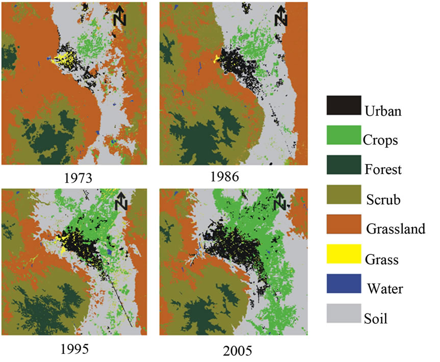
Figure 2. Classification of land use in the Valley of San Luis Potosi from satellite images for the years 1973, 1986, 1995 and 2000.

Figure 3. Growth of the urban area in the Valley of San Luis Potosi for the years 1959, 1970, 1993, 2000 and 2005 (adapted from Noyola et al., 2009).

Table 1. Changes of land use (Km2).
supply in the early 1900s was provided by groundwater from the shallow aquifer and the current supply comes primarily from the shallow aquifer and wastewater [23,24].
Land use changes in the VSLP have resulted in exchanges in the use of water. While 7.7% of the volume extracted in 2006 was for industrial use and 19.8% was for agricultural use, the volume extracted for industrial use doubled to 14% in 2008 and decreased to 4.8% for agricultural use; the demand for groundwater for human consumption is 78% [22].
Land use changes associated with human activities in the VSLP aquifer system have led to hydric stress, with the initial head loss in this analysis corresponding to 1977 (Figure 4). During this period, there were few wells in the aquifer and a drawdown had just begun. The exploitation of groundwater primarily occurred in the shallow aquifer through wells for domestic and agricultural use [1].
After a decade between 1977 and 1986, no significant changes were apparent. By 1986 (Figure 4), negative effects became evident with the deepening of a drawdown in the urban area of San Luis Potosi. During this period, the exploitation of the deep aquifer began, with drillings of wells at depths ranging between 60 and 200 meters. From 1995 to 1998, a rapid growth in the drawdown occurred (Figure 4) due to intensive exploitation of the deep aquifer, primarily for public-urban use, so that by 2007 (Figure 4), there was an overall decline in the piezometric which spread towards the southern portion of the city [1].
The depth of the cone increased 60 m from 1971 to 1995 [25]. The evolution of the static level for the period 1995-2001 shows that, during the 6-year period, its depth increased to 25 m in the center of the drawdown. That is, the level decreased 95 m over 30 years, with a descent rate of 3.1 m/year. The intense extraction and its effect on the drawdown reflects almost negligible recharge in the deep aquifer, a situation that has led to the mining of the aquifer.
One effect of the drawdown in combination with the tectonic geometry as well as differential soil compaction [26] is the appearance of fissures in the urban terrain (Figure 5).
Figure 4 shows the faults partially following the contours of piezometric levels and, in the process, streets, buildings, drainage and other infrastructure have been affected.