The Use of GIS and Google Earth for Preliminary Site Selection of Groundwater Recharge in the Azraq Oasis Area—Jordan ()
1. Introduction
In Jordan, groundwater is a major water resource for many areas of the country. However, Some of Jordan groundwater resources are presently exploited at maximum capacity and in some cases are exploited beyond their safe yield [1]. One of the efficient ways to overcome the deficit in groundwater resources is through recharging the water tables naturally or artificially [2]. In order to select the optimum sites for groundwater recharge, new techniques must be used. One of these techniques is GIS which plays a key role in maintaining data and analyzing optimal locations. It reduces time and cost of the site selection and provides a digital data bank for future monitoring program of the selected sites.
The use of GIS for selecting the optimum sites of groundwater recharge projects have been addressed in the literature by many researchers (e.g. [3-8]). In these researches, GIS was used in selecting the optimum sites for groundwater recharge projects at various parts of the world. In their quest to find the optimum sites, researchers applied GIS techniques on various maps including geology, fractures, soil, slope, rainfall and drainage.
There are two major techniques used within GIS environment to select the optimum site for any project; the Weighted Linear Combination (WLC) and the Boolean technique.
The Weighted Linear Combination (WLC) [9-16] is based on:
1) Standardizing the suitability maps2) Assigning weights of relative importance to the suitability’s maps3) Assigning weights of relative importance to the suitability’s maps4) Obtaining an overall suitability score.
While, in the Boolean technique [4,16-20], the variables are either true or false. This technique provides site selection of a project based on using either the OR (UNION) or the AND (INTERSECTION) operations.
This paper aims to use GIS and Google Earth to select the potential sites for groundwater recharge in the Azraq Oasis area/Jordan.
2. Materials and Methods
2.1. Study Area
The study area is located in the central northern part of Jordan. It lies with the Azraq Basin (Figure 1), with an estimated area of more than 46,756 ha. Azraq basin is considered one of the most important water sources in Jordan. Most of the pumped water is from the shallow aquifer system, which is currently overexploited. The basin has developed rapidly in the last ten years where significant parts of grazing lands are now used for agriculture. At the end of 1992 and as a direct result of the over pumping from the basin to agricultural activities and to supply Amman and Zarqa cities the natural springs in the basin dried out. This had lead to dry the oasis which considered as an alarming environmental disaster.
2.2. Site Selection Criteria and Applied Technique
The following table (Table 1) summarizes the preliminary site selection criteria for groundwater recharge within the study area.
In this research, the Boolean techniques will be used in selecting the optimum sites for groundwater recharge within the study area, Jordan. The implementation of this technique could be done through the use of raster calculation (multiplication) in ArcGIS (Raster GIS layers) or the use of Intersection (AND) command in ArcGIS (Vector GIS layers). In this research, raster calculation will be used on the available GIS data in order to perform the required data analysis.
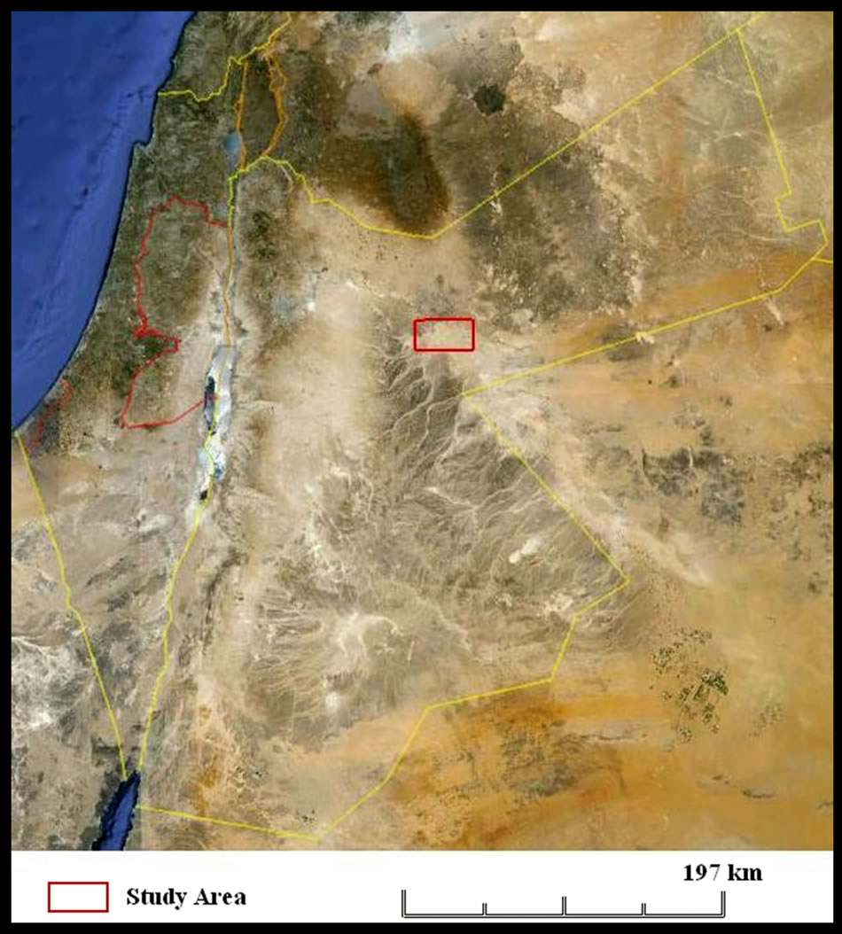
Figure 1. The study area location within Jordan (Google Earthâ).
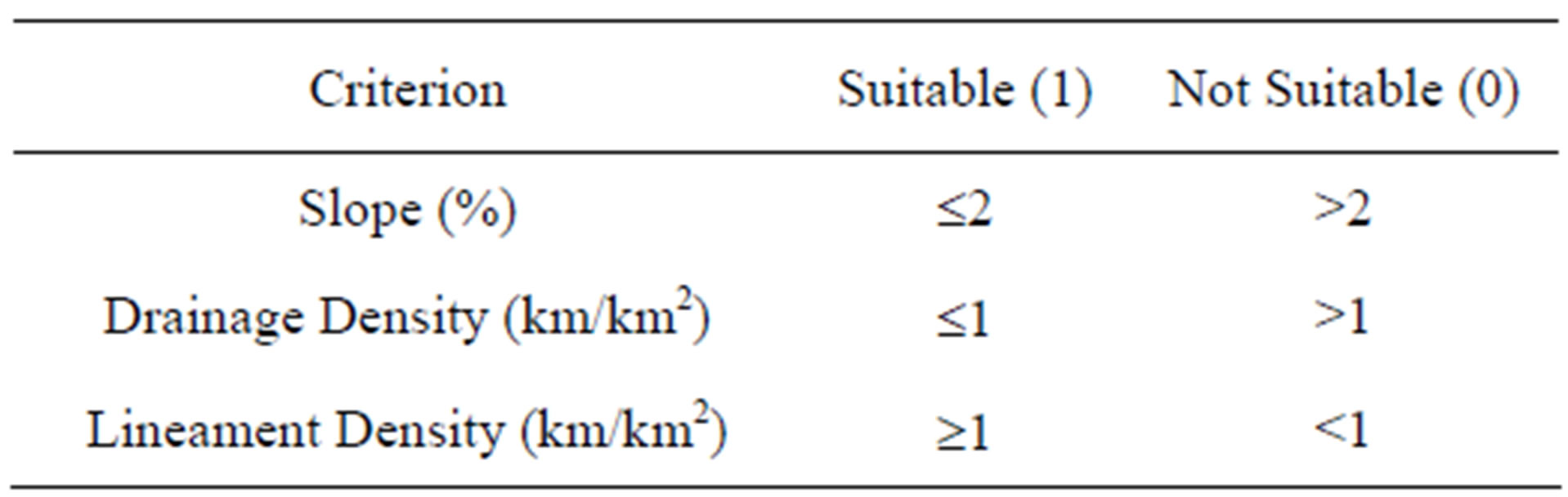
Table 1. Groundwater natural recharge selection criteria (After [3,8,18]).
2.3. Data Collection
In order to find suitable sites for the groundwater recharge projects, the following secondary data were gathered as shown in Table 2. Figures 2, 3 and 4 shows the major GIS layers used in this research.
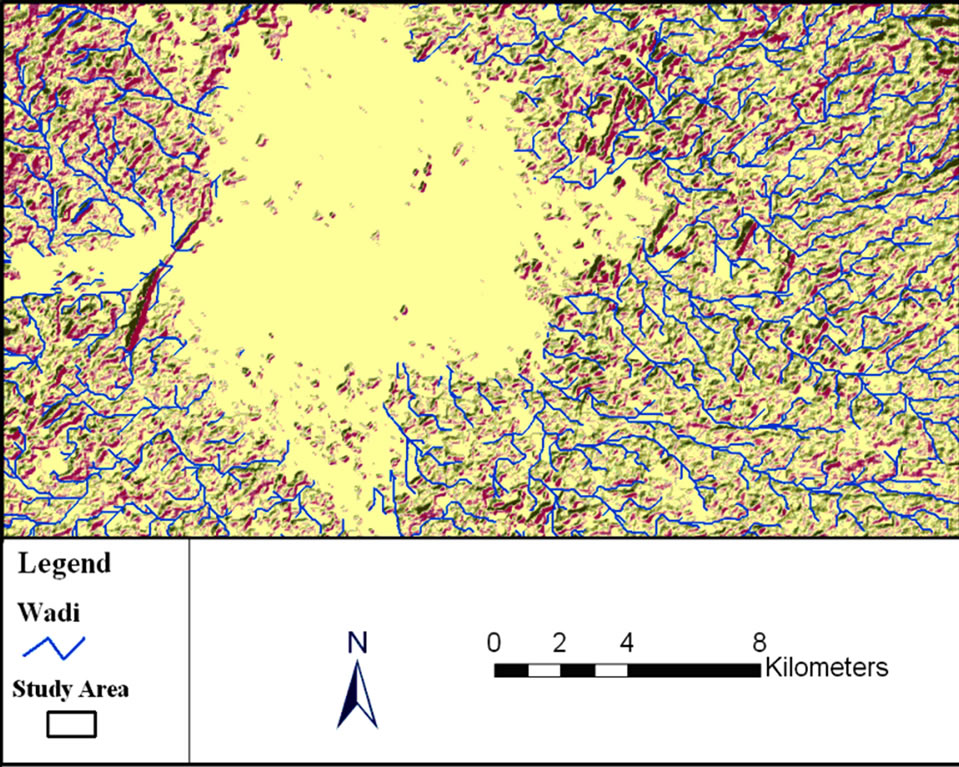
Figure 3. Drainage layer used in this research (Extracted from the USGS DEM).
3. Data Analysis and Results
Figure 5 illustrates the adopted data analysis methodology in this paper. This figure shows that each GIS layer has been operated on separately in order to fulfill the conditions stated in Table 1. A DEM was created using 30 m USGS SRTM data, then, a slope raster map was created. The slope was classified into <= 2% (suitable) and >2% (unsuitable) (Figure 6).
Using the USGS SRTM Data, the drainage map (Wadi) was extracted (Figure 3). This map was subjected to density calculation in ArcGIS and then classified based on Table 1 as shown in Figure 7. The lineament map was also subjected to density calculation, and then classified according to Table 1 as shown in Figure 8, where the suitable areas in all maps (Figures 6, 7 and 8) were given1, while the unsuitable ones were given 0.
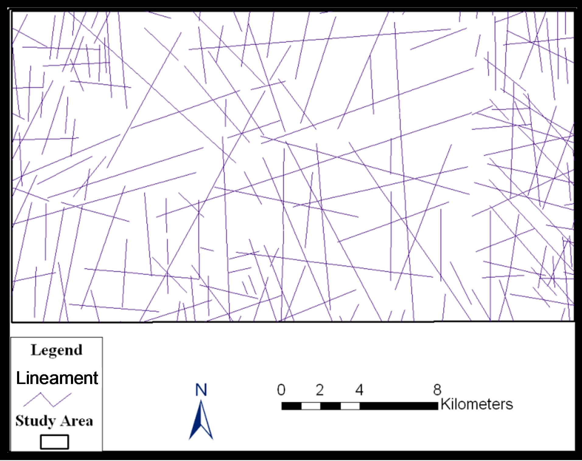
Figure 4. Lineament layer used in this research.
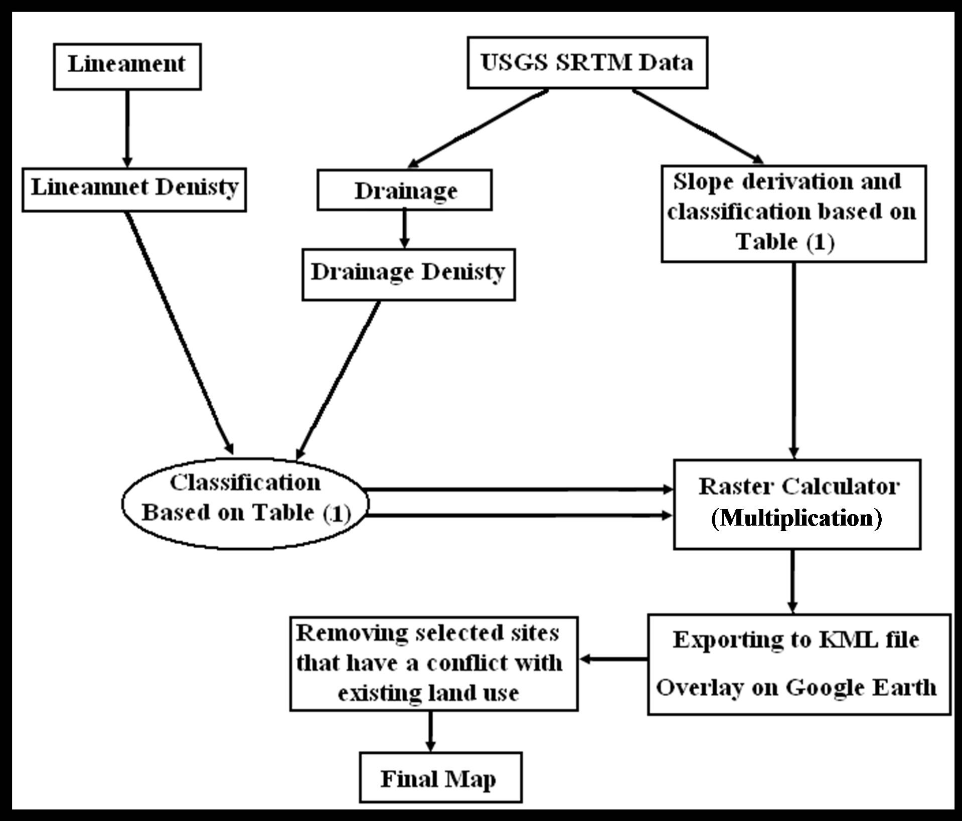
Figure 5. The methodology of data analysis within GIS environment.
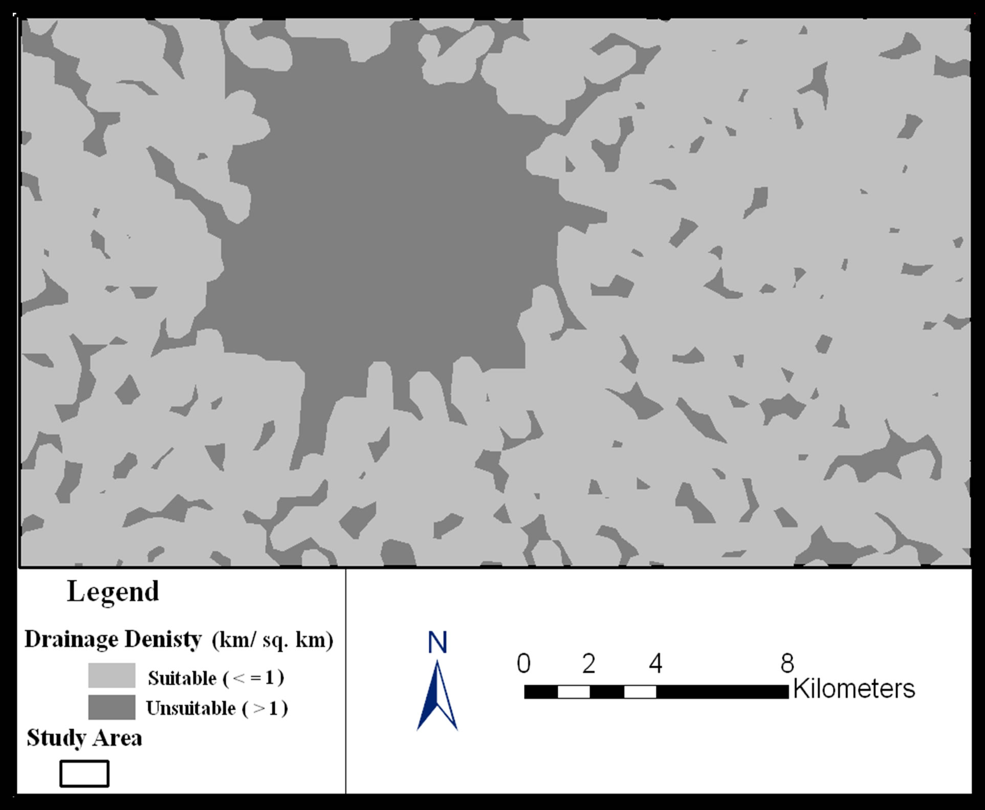
Figure 7. The drainage density (km/ sq. km).
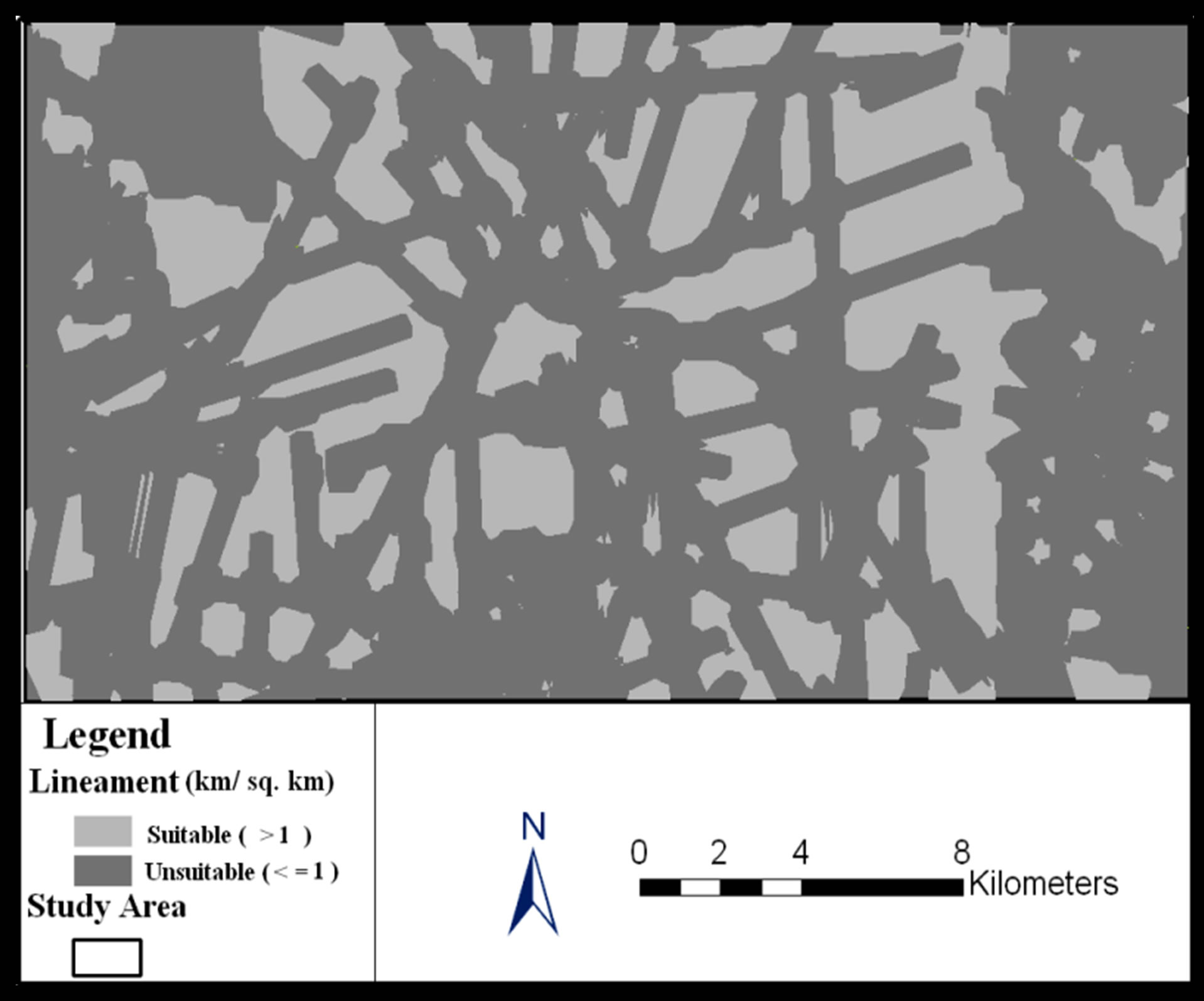
Figure 8. The lineament density (km/ sq. km).
Using the raster calculator in ArcGIS, maps shown in Figures 6, 7 and 8 were multiplied. Then, the resulted map was exported to KML format and overlaid on Google EarthÒ (Figure 9). This step was essential in order to overcome any overlap between the selected sites and existing land uses in the area. Finally, all sites that have area of less than 5 ha were removed from the final map. The final map is shown in (Figure10). The areas of the selected sites (35 sites) vary between 5.2 ha and 273.5 ha. The total area that has the potential for groundwater recharge is 1659.5 ha which represents approximately 3.55% of the study area.
4. Conclusions and Recommendations
Based on the finding of this research, it is concluded that:
1) Selecting the optimum sites for groundwater recharge is an important issue for Jordan due to the water shortage in the country and to assist in reversing the negative impacts of overexploiting of the limited groundwater resources. Implementing groundwater recharge projects in Jordan will help in achieving a balance between total pumping and recharge;
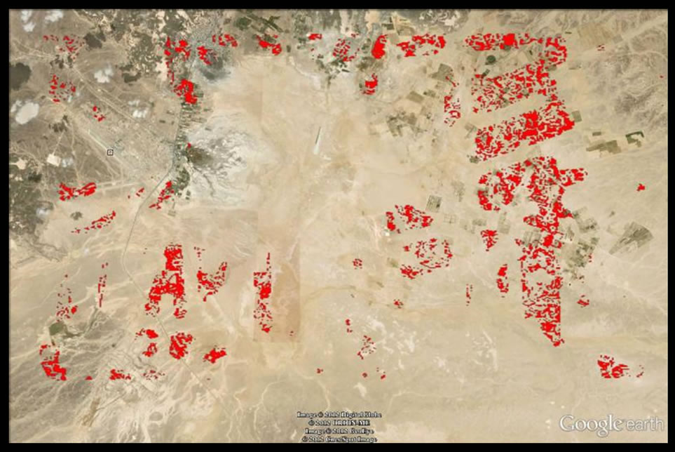
Figure 9. The selected sites overlaid on Google EarthÒ image.
2) GIS facilitates the analysis of different parameters related to the selection of groundwater recharge sites;
3) GIS is an effective tool for locating the optimum sites for groundwater recharge based on the available spatial data.
It is recommended to refine the outcomes of this research by introducing more criteria. Additional criteria may include but not limited to:
a) Rainfallb) Static Water Levelc) Vadose Zoned) Land use/Land covere) Aquifer Hydraulic conductivityf) Soil (Texture and hydraulic conductivity).
Also, it is recommended to conduct an on-site investigation for the selected sites including:
a) Geophysical investigation and b) Soil analysis.